
Caribbean, Windward Islands – Widow of Joachim Ottens, 1719-1723
DETAILED MAP OF THE WINDWARD ISLANDS “Tabula novissima atque accuratissima Caraibicarum insularum sive Cannibalum : quae etiam Antillae Gallicae dicuntur,…
Read more€975
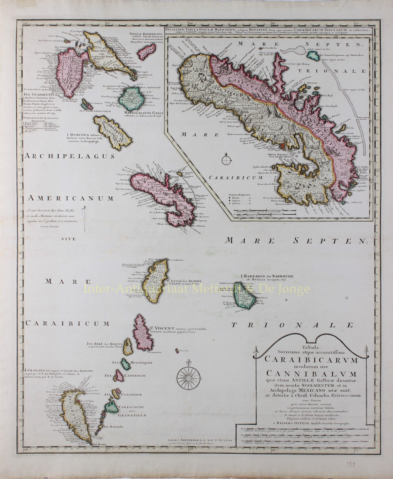
DETAILED MAP OF THE WINDWARD ISLANDS
“Tabula novissima atque accuratissima Caraibicarum insularum sive Cannibalum : quae etiam Antillae Gallicae dicuntur, item insulae Supraventum, et in Archipelago Mexicano sitae sunt, ac detectae a Christ. Columbo Ao. MCCCCLXXXXIII” [Latest and most accurate map of the Caribbean or Cannibal Islands: also called the French Antilles, or Windward Islands, located in the Archipelago of Mexico, which were discovered by Christopher Columbus in the year 1493.] Copper engraving “after the observations of skilful sailors” made by Reinier Ottens and printed by the Window of Joachim Ottens in Amsterdam 1719-1723. With original hand colouring. Size: 58 x 48 cm.
Detailed map of the Windward Islands from Guadeloupe south to Grenada, including the small islands of Mustique (Grenadines) and Ronde Island (Grenada), with a large inset map of Martinique. Grenada has been moved north and is shown west of Carriacou island, in order that it fits on the sheet.
Apart from topographical information, there are some notes of historic interest. According to the map tens of thousands live on Martinique (“Matanino as the locals call it and occupied by the French since July 1635”) and its tobacco is of the best quality. La Désiderade island was discovered by Christopher Columbus in 1493 on his second journey to America. “The island of Guadeloupe, called Carukeira [The Island of Beautiful Waters] by the locals, is very fertile with rice, maize, potatoes, ginger and sugar of different qualities. It is crowded with all types of parrots.” The island of Barbados has been occupied by the English in 1627. “St. Vincent, where the Caribs live, is most populated.”
Price: Euro 975,-