

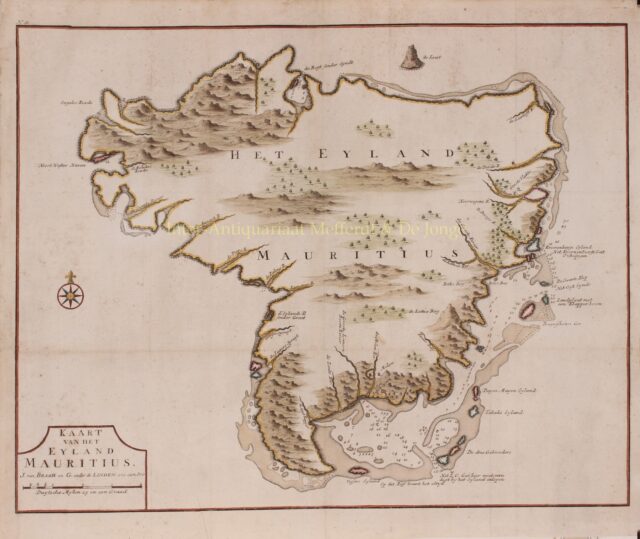
Mauritius – François Valentijn, 1724-1726
“Kaart van het Eyland Mauritius” , from François Valentijn’s “Oud en Nieuw Oost-Indien”, after a drawing by Johan van Leenen,…
Read more
“Kaart van het Eyland Mauritius”
Wybrant van Warwijck was the first Dutchman to arrive on Mauritius on September 18, 1598. Van Warwijck had strayed with five ships from the rest of the fleet of the so-called Tweede Schipvaart [second Dutch expedition], trying to reach Madagascar. He is said to have named the green island after Stadtholder Prince Maurice.
The Dutch East India Company (VOC) initially only used the island as a refreshment station and did not permanently inhabit it. Mauritius had two good natural harbours suitable for larger ships, in the Northwest “Port de Warwick” (nowadays Port-Louis) and the Southeast. The Northwestern harbour was a sheltered bay and the Southeastern was protected by a series of islands and reefs. Valentijn reports that it was very stormy around February.
Mauritius was a fertile island, rich with birds, the most important of which was the dodo for food, turtles and manatees. Pigs, deer and goats were left on the island for meat supply. In the course of the 1630s, the VOC found a permanent settlement necessary to prevent the French or the English from settling there.
There were forests of ebony. Cornelis Matelief had planted lemon and orange trees. With the ships rats came to the island, against which in turn cats were released.
Dutch colonization started in 1638 and ended in 1710, with a brief interruption between 1658 and 1666. Numerous governors were appointed, but continuous hardships such as cyclones, droughts, pest infestations, lack of food, and illnesses finally took their toll, and the island was definitively abandoned in 1710.
Francois Valentijn (1666-1727) was a minister, naturalist and writer who is best known for his Oud en Nieuw Oost-Indien [Old and New East-India], a history of the Dutch East India Company (VOC) and their activities in the East Indies. Valentijn’s maps were among the most accurate and large scale productions detailing the East Indies thus far published. As VOC officer, Valentijn doubtless had access to VOC manuscript records which he complied into his remarkable collection of maps. In fact, Valentijn’s maps are so superior to previous maps that their publication itself is rather surprising. The VOC’s policy of extreme secrecy, especially regarding cartographic matters, historically limited publication of their charts.
Price: SOLD