

Russia antique map dedicated to Peter the Great – Herman Moll
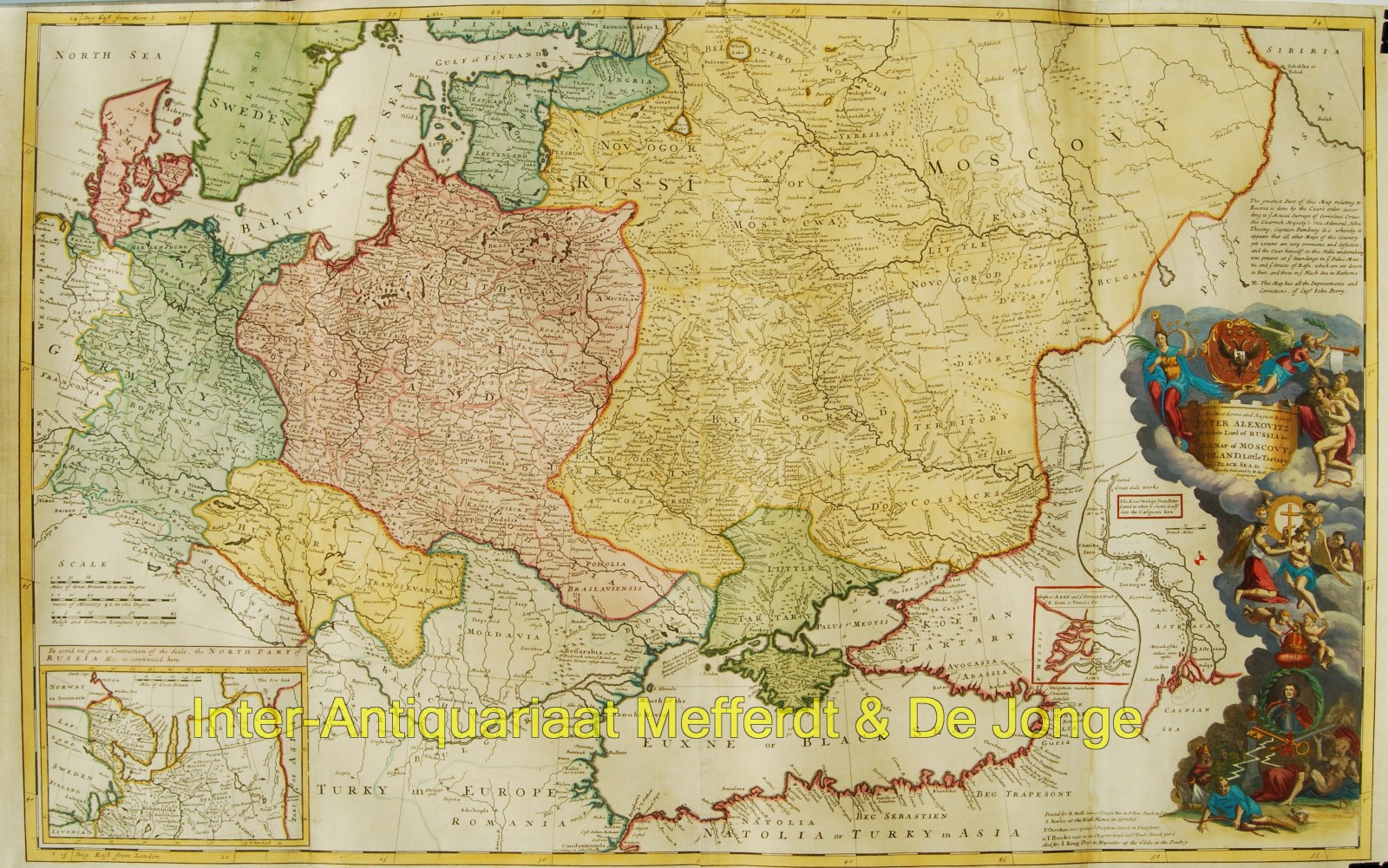
“Map of Moscovy, Poland, Little Tartary, and ye Black Sea” Striking large format (60,5 x 98 cm) map of Russia, Ukraine, Poland, Finland and the Baltic Countries and extending south to the Black Sea and the Balkans. Copper engraving, published by Herman Moll in 1729, coloured by a later hand.
An imperialist at heart, Herman Moll did little to disguise his admiration for Czar Peter the Great (ruled 1683-1725), to whom this map was dedicated. Peter’s aspirations for a greater Russia required access to both the Baltic and Black Seas. By the time this map was conceived, he had secured access to both by hard-won military campaigns over Sweden and the Ottomans. Accordingly, an inset on this map features the new Russian port on the Sea of Asov, an arm of the Black Sea. The cartouche is a resplendent tribute to Peter, who is depicted in an oval draped with laurels, while above angels and cherubs celebrate his accomplishments, and his vanquished foes wallow below. Moll incorporated new geographical information in this map which came from surveys commissioned by the Czar.
The present map was part of Herman Moll’s magnificent folio work, “a New and Compleat Atlas”. Moll was the most important cartographer working in London during his era, a career that spanned over fifty years. His origins have been a source of great scholarly debate; however, the prevailing opinion suggests that he hailed from the Hanseatic port city of Bremen, Germany. Joining a number of his countrymen, he fled the turmoil of the Nordic Wars for London, and in 1678 is first recorded as working there as an engraver for Moses Pitt on the production of the English Atlas. It was not long before Moll found himself as a charter member of London’s most interesting social circle, which congregated at Jonathan’s Coffee House at Number 20 Exchange Alley, Cornhill. It was at this establishment that speculators met to trade equities (most notoriously South Sea Company shares). Moll’s coffeehouse circle included the scientist Robert Hooke, the archaeologist William Stuckley, the authors Jonathan Swift and Daniel Defoe, and the intellectually-gifted pirates William Dampier, Woodes Rogers and William Hacke. From these friends, Moll gained a great deal of privileged information that was later conveyed in his cartographic works, some appearing in the works of these same figures. Moll was highly astute, both politically and commercially, and he was consistently able to craft maps and atlases that appealed to the particular fancy of wealthy individual patrons, as well as the popular trends of the day. In many cases, his works are amongst the very finest maps of their subjects ever created with toponymy in the English language.
The map includes a number of interesting annotations, most notably the note in the upper right above the cartouche which provides that Moll has drawn the map from a map prepared by Cornelis Cruys, John Thesing and Captain Pamburg, at the direction of the Czar, with improvement and corrections from Captain John Perry. The map also includes inset maps showing the course of the Wolga River, the mouth of the Don River and the area contiguous to the White Sea.
Cornelis Cruys (1655-1727) was Vice Admiral of the Imperial Russian Navy and the first commander of the Baltic Fleet. He was born as Niels Olsen (Olufsen) in Stavanger Norway, before changing his name. Cruys lived in Amsterdam for 18 years before joining the Russian Navy. Cruys introduction to the Russian Navy was as a direct rsult of Czar Peter the Great’s Grand Embassy of 1697, which included a visit to Amsterdam to study shipbuilding and related arts. With the assistance of Nicolaas Witsen, Mayor of Amsterdam, the Czar gained access to the shipyard of the Dutch East India Company for 4 months, where he recruited Cornelis Cruys to join the Russian Imperial Navy as Vice Admiral, where he became the primary architect of the westernization of the Russian Navy. Among other accomplishments, he made the first maps of the Don River and the Asov Sea.
Price: SOLD