
Wall map of the world – Clouet, Mondhare, 1785
STUNNING WALL MAP OF THE WORLD “Carte Generale de la Terre ou Mappe Monde avec les Quatres Principaux Systemes .…
Lees verder
STUNNING WALL MAP OF THE WORLD
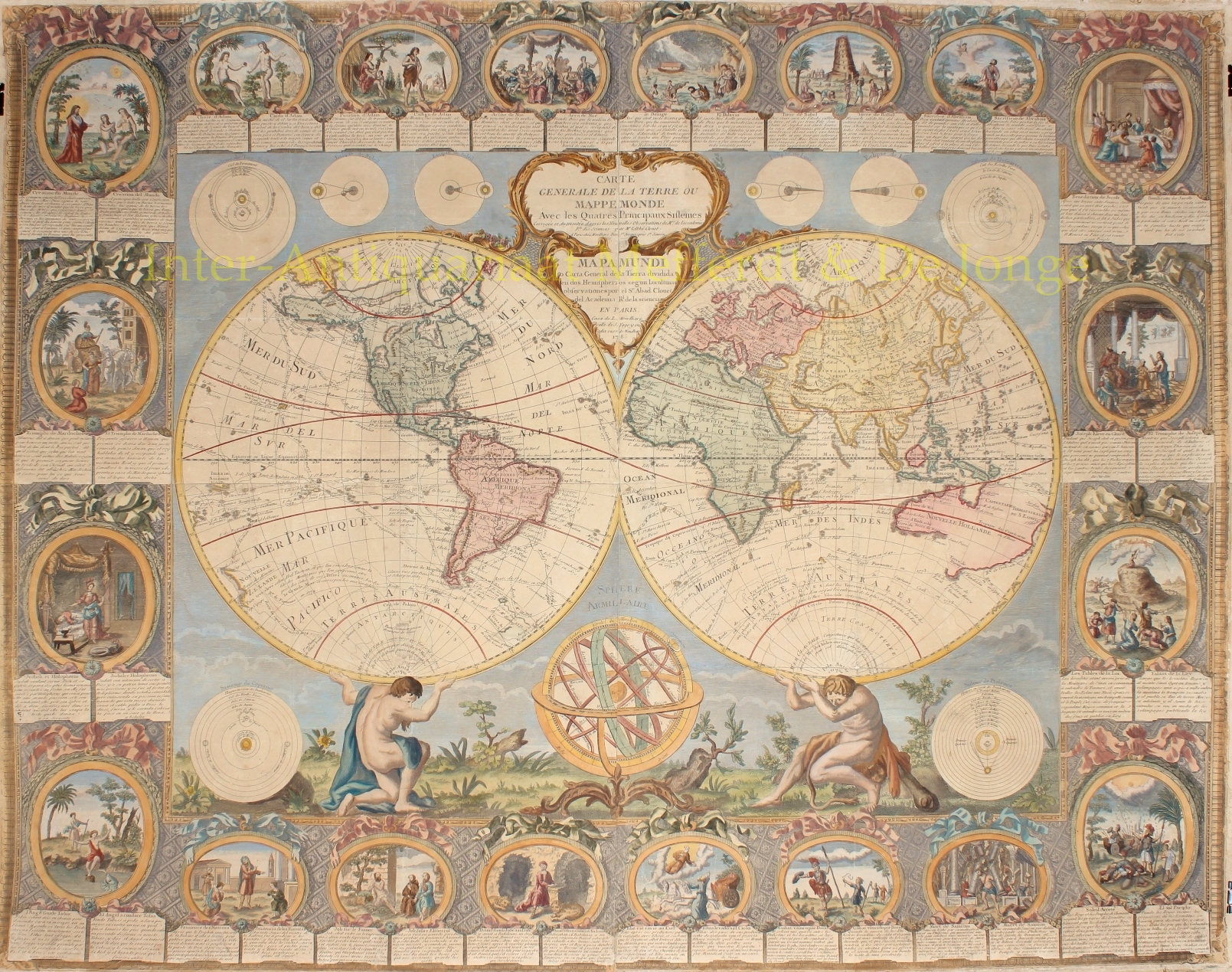
“Carte Generale de la Terre ou Mappe Monde avec les Quatres Principaux Systemes . . .” Copper engraving by Jean Baptiste Louis Clouet, published in 1785 by Louis Joseph Mondhare. Coloured by a later hand. Size: 96,5 x 123 cm. (Frame: 118 x 144 cm)
Dramatically composed world map, in which mythological figures support the two hemispheres with the solstice. Although its baroque decoration depicts biblical scenes, the map itself bows to modernity by including the tracks of the major Pacific voyages: Jacob Le Maire, Ferdinand Magellan, and Abel Tasman. It is an excellent view of the world as it was known just prior to the great transoceanic explorations that were being launched at the time the map was issued.
The Clouet/Mondhare map of the world is one of the most decorative double hemisphere wall maps published in the second half of the 18th century. The map continues the French aristocratic tradition popularised during the reign of Louis XIV. In this grand tradition, the map serves the dual purpose of being both a spectacular object, utilised by the French aristocracy of the 18th century in decorating libraries and salons, and a statement of the worldliness of its owners, depicting the progress of the exploration of the world and scientific models of the known universe, in a perfect marriage with imagery from the classical world and scenes from the Old Testament.
The map provides a fine depiction of the most up-to-date information, showing the discoveries of Hawaii and the southeastern coastline of Australia, the earlier routes of numerous 17th and 18th Century explorers are noted, with particular emphasis given to the explorations of Abel Tasman in the Southern Hemisphere, both in New Zealand and Australia.
While the routes of many major explorer’s are depicted, publisher Mondhare has retained the mythical depiction of the Sea of the West in North America and offers a number of tantalising options for a northwest passage, while also including a massive nascent depiction of Alaska and the Aleutian Archipelago, which was then at the end of a 40 year period of debate between the theories of the Paris based De L’Isle family of mapmakers, the English cartographer Thomas Jefferys and the Russian Academy.
The map is embellished with eight small circular astronomical diagrams including images of lunar and solar eclipses and the known solar system. In the middle below the hemispheres, a model shows us tropics and meridians.
The episodes from the Old Testament are in twenty vignettes with descriptive text in French and Spanish. Clockwise from the upper left: the story of Creation, Adam and Eve in Paradise; the Fall of and Punishment of Mankind after disobeying God by eating from the forbidden fruit; Noah’s Ark, where God told Noah to enter the ark with his household and the animals, the ark being afloat throughout The Deluge before it came to rest on the Mountains of Ararat; the Tower of Babel, where man sought to build a tower with its top in the sky, to make a name for themselves and where God confounded their speech so that they could no longer understand each other and scattered them around the world; Abraham who’s belief was tested by commanding the sacrifice of his son Isaac; Jacob blessing his sons; the glory of Joseph with his prediction of seven years of abundance and seven years of famine; the Tables of the Law inscribed with the Ten Commandments when Moses ascended Mount Sinai; the solar eclipse; the death of Samson in the temple of the Philistines; the victory of David over Goliath; Elijah riding his chariot of fire to heaven; Daniel in the lions’ den; Job, struck by misfortune, sitting on a dunghill, but despite all his trials faithful to God; Jonah encouraging the Ninevites to do penitence; summoned by archangel Raphael, Tobias Catching a Fish; and lastly the story of Judith. Where Judith, a daring and beautiful widow, who is upset with her Jewish countrymen for not trusting God to deliver them from their foreign conquerors, goes to the camp of the enemy general Holofernes, promising him information on the Israelites. Gaining his trust, she is allowed access to his tent one night as he lies in a drunken stupor. She decapitates him and Israel is saved.
Abbot Jean Baptiste Louis Clouet (c. 1730 – 1790) was a French cartographer active in the mid to late 18th century. Clouet held the post of Royal Geographer of the Academie des Sciences de Rouen, he had offices in Paris and Cadiz. Clouet’s most important work is his Geographie Moderne, which was published in various editions from 1776 – 1793. Clouet also produced a series of stunning and highly decorative wall maps depicting the various continents. He followed in the footsteps of Jean-Baptiste Nolin and other French cartographers, reissuing these grand wall-maps in the latter part of the 18th century to decorate the houses of Paris and more unusually Spain.
Price: SOLD