

World map – Jean Baptiste Nolin, published by Crépy in 1784
STUNNING WORLD WALL MAP SURROUNDED WITH THE STORY OF CREATION
“One of the Finest Large-Scale World Maps to be Produced”– Shirley
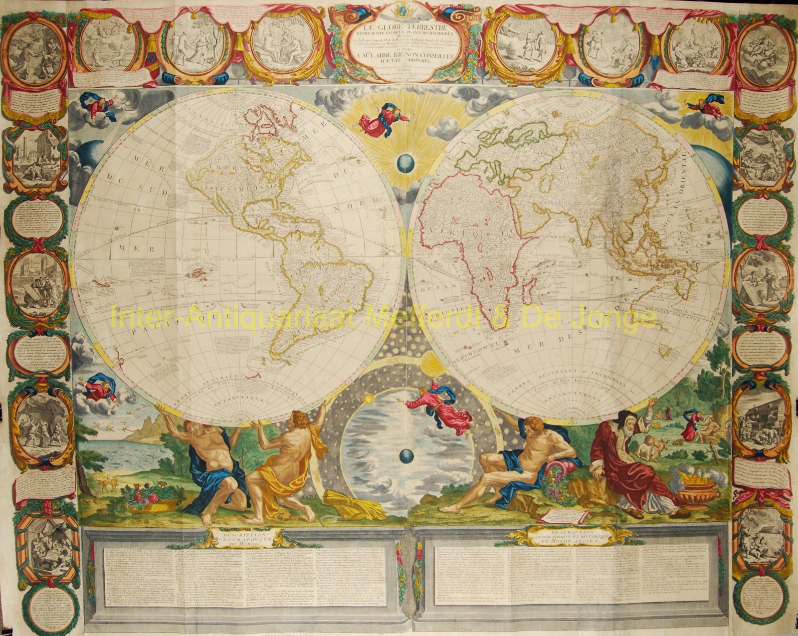
“Le globe terrestre représenté en deux plans-hémisphères : dressé sur la projection de Mr. de la Hyre de l’Académie Royale des Sciences, et sur plusieurs routiers et mémoires des plus habiles pilotes et savans voyageurs le tout rectifié et calculé selon les dernières observations, et dédié Mgr. l’Abbé Bignon, conseiller d’état ordinaire. Paris : se vend présentement (…) chez Crépy 1784“. Rare, separately published wall map. Copper engraving on four sheets by Jean Baptiste Nolin (1648-1708). Original hand colouring with later additions. Size: 118,5 x 149,5 cm
In quality of engraving and beauty of design, this wall map compares favourably with even the comparably sized masterworks of the Dutch Golden Age that preceded it. Moreover, as Shirley notes, “This splendid Globe Terrestre by J.P. Nolin”, first issued in 1700, “is one of the finest large-scale world maps to be produced and is a fitting bridge between the geographical and artistic skills of the seventeenth century and the century to come.”
Shirley also notes that, geographically, the map is “particularly interesting” in the areas of North America and Australia. Nolin was the first to delineate the famous Mer de l’Ouest in North America, giving fuel to the prominent fantasy of a Northwest Passage. Although the fictitious sea has been reduced in size in this later edition, the enthusiasm for a Northwest Passage remains, this time portrayed in the Detroit d’Anian which attempts to link Hudson Bay to the Pacific Ocean. Furthermore, the map dramatically updates North America, most notably with a largely accurate and complete Mississippi River.
Although more Pacific islands and an expanded Solomon Island group were added to this 1784 edition, it retains the tentative east coast of Australia, not yet fully incorporating the discoveries of Captain James Cook’s voyages in the 1770s.
Nolin’s world map offers much more than a compilation of recent discoveries and observations of “habiles pilotes et savans voyageurs (skilled pilots and knowledgeable travelers).” Much of the artistry was the work of the celebrated French painter Bocquet. The map is presented in the context of a biblical narrative stretching back to the beginnings of the universe and the story of Creation. The margins beyond the hemispheres portray the six days of creations (before God took a day of rest), with the personified four seasons at the base of the hemispheres assisting the precession of the equinoxes. The outer margins take up the story with further episodes from the Book of Genesis the Garden of Eden, Adam and Eve, Cain and Abel, the progeny of Seth and Cain, the death of Adam at the age of 930, and Noah’s Ark. The narrative panels conclude with the giving of thanks after the Ark settled atop Mount Ararat (prominently featured on the map southwest of the Black Sea).
At the bottom of the map’s hemispheres and their decorative surround, are architectural columns of text containing a Description Geographique du Monde and a Description Geographique et Historique du Monde Ancien with an explanation of the story of Creation until the Deluge.
Condition : Some resoration as usual on these large maps. Several tears have been strengthed. In the Asian continent, a piece of 2 x 11cm has been reinstated. For being an 18th century wall map, the map overall is in a very good condition.
Literature: Shirley (World) 605. Mcguirk, Mer de l’Ouest, 1
Price: SOLD