

Westelijk Halfrond – Abraham Ortelius, 1570
€4.500
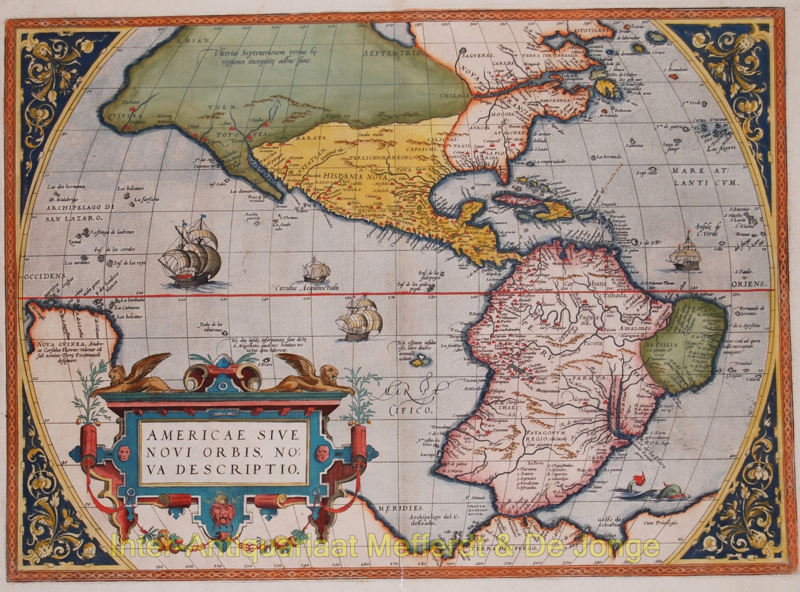
ONE OF THE MOST ICONIC MAPS OF THE WESTERN HEMISPHERE
“Americae Sive Novi Orbis, Nova Descriptio“, copper engraving published by Abraham Ortelius featured in his “Theatrum Orbis Terrarum”, the first modern atlas of the world, from 1570 onwards. Here in a second state of first plate with Latin text on verso. Coloured by a later hand. Size: 36,6 x 50,7 cm.
Without a doubt one of the most recognized and influential maps of the Americas from the sixteenth century. It formed the European perception of America. When the map was first published, it was the best map of the Americas available. It was in fact the first of it’s kind to achieve wide circulation through an atlas.
North and South America stretch across this single hemisphere map. To the north, North America somewhat resembles the continent we know today, except the area near Alaska is undefined and the northwest bulges to the east. South America is a squat landmass, early editions have an extension in the southwest that would disappear in later editions of the map.
The title is decorated with the key-like geometric decorations common to the maps in Ortelius’ atlas. In the ocean, a sea monster lurks. In the Pacific, ships stream through the water, their sails filled with imaginary winds.
The Straits of Magellan separate South America from a large southern continent that extends all the way to New Guinea. Tierra del Fuego, named by Ferdinand Magellan because he saw so many small fires burning there, is part of this continent. The name “Novae Guinea”, or New Guinea, was coined by Spanish explorer Yñigo Ortíz de Retes in 1545, and it refers to his opinion that the appearance of the native peoples resembled the natives of the Guinea region of Africa.
Two place names in the northwest of North America are particularly interesting. Anian derives from Ania, a Chinese province on a large gulf mentioned in Marco Polo’s travels . The gulf Polo described was actually the Gulf of Tonkin, but the province’s description was transposed from Vietnam to the northwest coast of North America. The first map to do was Giacomo Gastaldi’s world map of 1562, followed by Bolognino Zaltieri and Gerard Mercator in 1567. The Strait then became shorthand for a passage to China, i.e. a Northwest Passage. It appeared on maps until the mid-eighteenth century.
Quivira refers to the Seven Cities of Gold sought by the Spanish explorer Francisco Vasquez de Coronado in 1541. In 1539, De Coronado wandered over what today is Arizona and New Mexico, eventually heading to what is now Kansas to find the supposedly rich city of Quivira. Although he never found the cities or the gold, the name stuck on maps of southwest North America, wandering from east to west.
Ortelius’ ability to locate and draw upon both Spanish and Portuguese sources is apparent throughout the map, and is quite remarkable, given the manner in which each nation guarded its cartographic information. Both nations kept their geographic knowledge locked in a single institution, with all cartographic knowledge maintained on a single master map. Copies of the master map were closely monitored and pilots could be punished for not returning their charts; however, no vault is impenetrable and geographic secrets leaked out, including to Ortelius in Antwerp.
The influence of this and other Ortelius maps stems from the popularity and dominance of his atlas in the European market. In 1570, Ortelius published the first modern atlas; that is, a set of uniform maps with supporting text gathered in book form. Previously, there were other bound map collections, specifically, the Italian Lafreri atlases, but these were sets of maps-not necessarily uniform-selected and bound together on demand.
Theatrum Orbis Terrarum, Ortelius’ atlas, outperformed competing atlases from other cartographic luminaries like the Mercator family. Between 1570 and 1612, 31 editions of the atlas were published in seven languages. This map, in its first edition, appeared in the very first 1570 atlas.
Price: Euro 4.500,-