

Normandië en Picardië – Romeijn de Hooghe, Pieter Mortier, 1693
€2.150
BEAUTIFUL MAP OF NORMANDY AND PICARDY
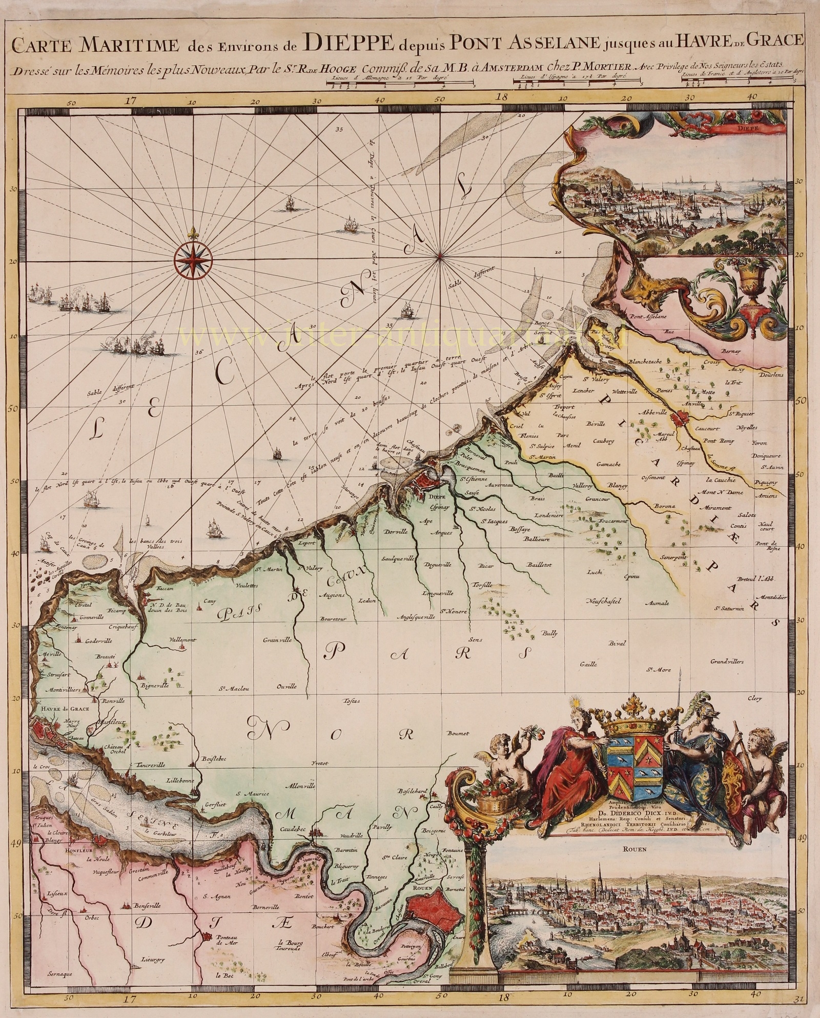
“Carte Maritime des Environs de Dieppe depuis Asselane jusques au Havre de Grace“, copper engraving made by Romeijn de Hooghe and published by Pieter Mortier of Amsterdam in 1693. Coloured by a later hand. Size: 62 x 50 cm.
Elaborately etched and engraved chart of northwestern France with the regions of Picardy and Normandy including the town of Dieppe and the mouth of the Seine river with Le Havre and Rouen. There are lovely inset views of Dieppe and Rouen.
Dieppe was the premier port of France in the 17th century and had housed the most advanced French school of cartography in the 16th century. The town was largely destroyed by an Anglo-Dutch naval bombardment in 1694.
Le Havre affirmed its maritime and international calling during the 17th century when the French West India Company settled there in 1643. There were imports of exotic products from America (sugar, cotton, tobacco, coffee, and various spices) and slave trade enriched local traders. Le Havre was the third largest French slave trade port (after Nantes and La Rochelle. The Anglo-Dutch bombarded the city several times during the Nine Year’s War, notably in 1694 and in 1696.
In the 17th century prosperity was brought to the city of Rouen through the textile trade and the increased use of port facilities, as well as the development of public transportation and other industries. Rouen was well known for the production of wool and faience (glazed ceramic ware); wool being the main source of wealth for the city.
The map is from the “Cartes marines a l’usage des armées du Roy de la Grande Bretagne”, the second part of the “Neptune François”, in which charts are larger and more lavishly decorated than those of any preceding book of this kind. This magnificent work was intended more as a show piece than something to be used by pilots at sea. (According to Cor Koeman it is “the most expensive sea-atlas ever published in Amsterdam in the seventeenth century”.)
This part of the atlas, which contains nine charts, constitutes “the most spectacular type of maritime cartography”. It was prepared for the use of William III who needed accurate information on the Channel coasts for his war plans against king Louis XIV of France. In 1694 he sent an expedition to attack several of the ports which are illustrated in the etched vignettes that decorate these charts. What has won their lasting fame, however, is the identity of their author: the artist-engraver Romeijn de Hooghe (1645-1708). Since he undertook all stages of production himself, the charts exhibit a rare harmony of design and execution. The allegorical subjects which characterise his designs are here transformed into dramatic cartouches.
This map is dedicated to Diederik Dicx (a high ranking Dutch civil servant who was bailiff of the water board of Kennemerland (NL).
Price: Euro 1.350,-