

Suriname and Guyana – Isaak Tirion, 1758-1767
€495


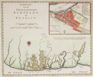
“Landkaart van de Volksplantingen Suriname en Berbice” [Map of the Colonies of Suriname and Berbice] with inset map of the city of Paramaribo, published by Isaak Tirion between 1758 and 1767 as part of his Hedendaagsche Historie of tegenwoordige staat van Amerika. Coloured by a later hand. Size 32 × 38.5 cm.
The foundations of present-day Suriname were laid by the English colonisation along the Suriname River, begun in 1651. When the thriving young colony was conquered in 1667 by Abraham Crijnssen in the name of the province of Zeeland, the territory extended as far as “the west side of the River Coppename.” Further west lay another Zeelandic colony, Berbice (or “Berbiesjes”), founded by Abraham van Peere in 1627. Between the two colonies stretched the basin of the Corantijn River, a virtually empty no-man’s-land. To avoid potential conflicts, an agreement was reached between Van Peere and Governor Van Sommelsdijk. In any case, on 18th-century maps the western boundary of Suriname was shown as a straight line running from the Duivelskreek (a now-vanished small river) along the easternmost bend of the Canje River, a tributary of the Berbice River.
Perhaps the most interesting feature of this map is the inset of the city of Paramaribo in the upper right corner. It shows the “Portugeesche Jooden Synagoog” [Portuguese Jewish Synagogue] and the “Duitsche Synagoog” [German Synagogue]. Suriname was one of the most important Jewish population centres in the Western Hemisphere. In 1665, after three successive groups of Jewish colonists had arrived in Suriname, the British had granted them various privileges, including freedom of religion, permission to build synagogues and Jewish schools, as well as the right to maintain their own court of justice and civic guard. When the Dutch took over the colony in 1667, these privileges for the Jewish community remained intact. By the early 18th century the Jewish community in Suriname numbered nearly 600 people and owned around 40 plantations and a considerable number of enslaved people. Their wealth was reflected in the Jewish cemetery at Jodensavanne, filled with marble tombstones imported from Europe and considered one of the finest in South America. After the decline of the plantation economy, a large portion of the Jewish community moved to Paramaribo, where the Ashkenazi Jewish community built the “German” synagogue in 1719—marked on this map—and the Sephardic Jewish community built the “Portuguese” synagogue in 1735.
Literature: C. Koeman (1973) “Bibliography of Pinted Maps of Suriname”, nr. 15
Price: Euro 495,-