

Amsterdam – Joan Blaeu, 1649
€3.650


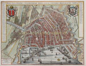
FAMOUS PLAN OF AMSTERDAM
“Amstelodami celeberrimi Hollandiae emporii delineatio nova.” Copper engraving of Amsterdam published by Joan Blaeu in 1649, Coloured by a later hand. Size: 41 × 53.5 cm.
This first edition of Blaeu’s plan of Amsterdam was made in 1649 for his celebrated townbook “Theatrum Urbium Foederatarum Belgii cum earum Descriptionibus” [The Theatre of the Cities of the United Netherlands with their Descriptions]. At this time, the Amstel was still a winding river flowing through the very heart of the city, covered only where it passed beneath Hendrick de Keyser’s Exchange and the fish market on the Dam.
The plan was not an entirely original work. Blaeu based his image on an earlier plan by Henricus Hondius, which he updated to approximately 1647—the grain warehouses on the Brouwersgracht, built in 1647/1648, already appear on Blaeu’s map. On the left and right are narrow panels listing the names of buildings, sluices, markets, gates, and other features, with numbers corresponding to the map itself. The inclusion of two coats of arms in the upper corners follows a tradition already established in the city atlases of Georg Braun and Franz Hogenberg at the end of the sixteenth century. In their works, the city’s coat of arms (here shown on the left with the imperial crown) is paired with that of the province; Blaeu replaced the latter with a shield bearing the seal of the city.
The city is still surrounded by its medieval defensive wall, although this was to be shifted southwards and eastwards as part of the planned Fourth Expansion (Vierde Uitleg). In the lightly tinted suburban areas at the city’s edge, Blaeu already roughly indicated the course of a new city wall around the proposed expansion. Around 1650, however, the city council opted for a much more extensive layout, rendering the map outdated. Consequently, in 1658/1659, Blaeu revised and improved the plan for the later editions of his city atlas.
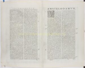
On the verso, Joan Blaeu describes in Latin how Amsterdam developed from a small settlement into a world city. He begins with a low, marshy landscape along the Amstel, where poor fishermen settled beside a strategic dam that gave the city its name. From these modest beginnings, aided by divine blessing and a favourable location, Amsterdam grew into a fortified city endowed with rights, gates, and commercial privileges.
Literature:
- D’Ailly “Catalogus van Amsterdamsche Plattegronden” (1934), no. 133;
- Amsterdam municipal archive(2007), exhibition catalogue “Het aanzien van Amsterdam”, no. 41.
- Marc Hameleers (2003) “Amsterdamse Plattegronden 1866-2000”, no. 29.3
Price: Euro 3.650,-