

Batavia (Jakarta) – Herman Moll, 1744
€475
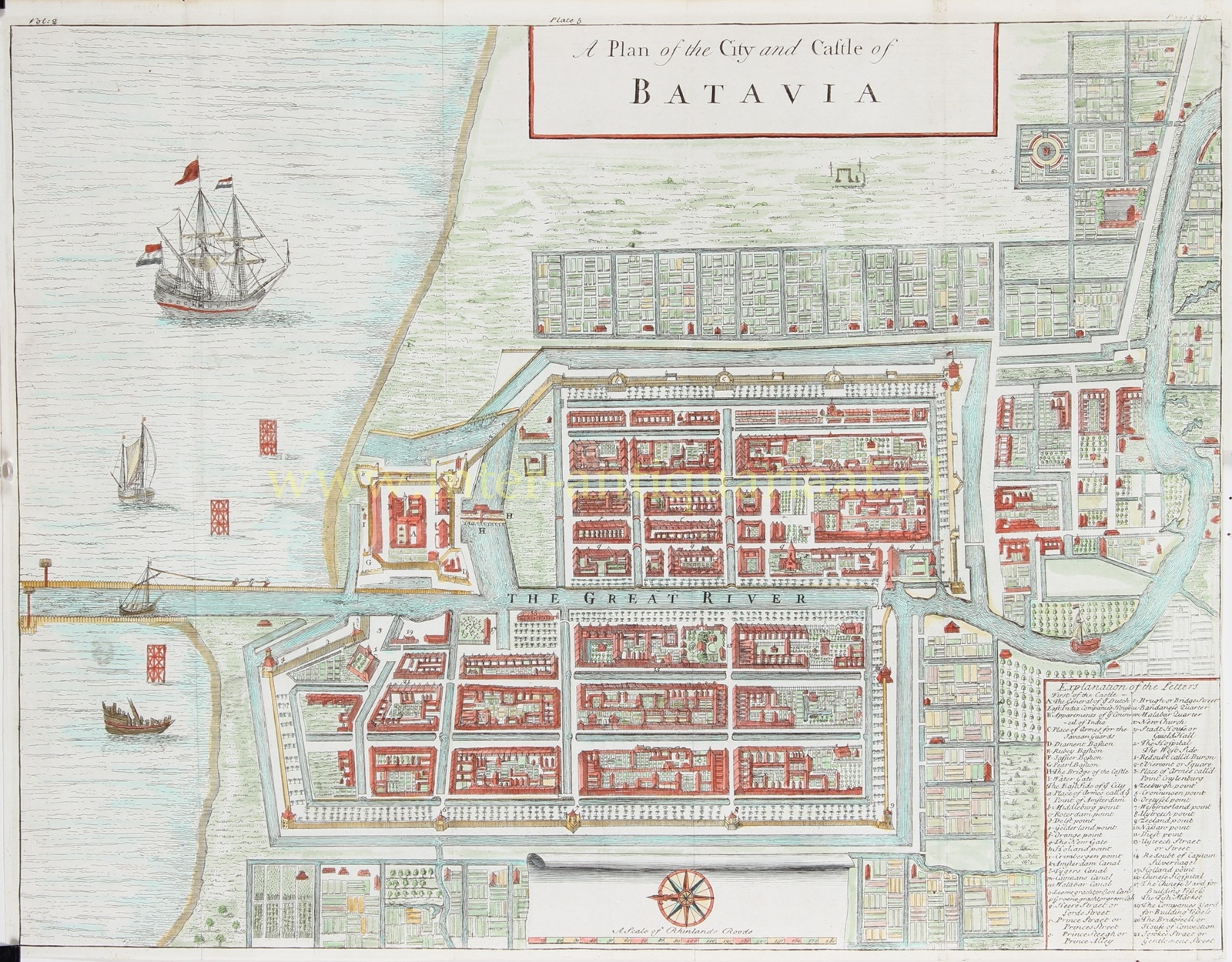


A Plan of the City and Castle of Batavia” Copper engraving after the design by Herman Moll, published in London between 1724 and 1738 by Thomas Salmon as part of his “Modern History: or the Present State of All Nations …” Coloured by a later hand. Size: 41.9 × 32.3 cm.
This finely engraved plan depicts Batavia (present-day Jakarta) in its 18th-century form, with the regular urban layout established by the Dutch East India Company (VOC) according to Dutch town-planning principles. At the centre runs The Great River (the Ciliwung), dividing the city into two parts and flowing through the harbour into the Bay of Batavia, where a Dutch East Indiaman is shown at anchor.
In the north-west corner lies the Castle of Batavia, the administrative and military headquarters of the VOC in Asia. The legend lists, among others, the General’s House, the Apartments of the Council of India, and the four bastions Diamond, Ruby, Sapphire, and Pearl. The city gates, canals, and “points” (bastions) are named after Dutch towns and provinces: Rotterdam, Middelburg, Zeeland, Utrecht, Gelderland, Holland, and Nassau Point.
The legend also provides detailed references to quarters and canals: Tygers, Leeuwe, Groene, Malabar, and Amboinsche Canal, as well as the Bandanese Quarter and Malabar Quarter. Other entries include the Stadt-House or Guildhall, New Church, Hospital, Chinese Yard for Building Vessels, Fish Market, and the Bridewell or House of Correction.
The map’s geometric plan reflects the Dutch ideal of order and rationality imposed upon a tropical landscape that the Company sought to control through canals, dikes, and fortifications. In the 17th and 18th centuries, Batavia was hailed as the “Queen of the East” — the administrative and commercial centre of the VOC empire.
Herman Moll (c. 1654–1732), German-born but active in London, was one of the foremost cartographers of the early 18th century. He began his career as an engraver for Moses Pitt on the ill-fated English Atlas — a grand project that ultimately bankrupted Pitt. Moll also engraved for Sir Jonas Moore, Grenville Collins, John Adair, and the firm of Seller & Price. By the early 1680s he was publishing his own maps, and by the 1690s he had established his own shop.
Moll’s work soon earned him a place among a lively circle of intellectuals and adventurers who met at Jonathan’s Coffee House, 20 Exchange Alley, Cornhill — also a hub for early stock traders. His acquaintances included the scientist Robert Hooke, the antiquarian William Stukeley, the writers Jonathan Swift and Daniel Defoe, and the sharp-minded privateers William Dampier, Woodes Rogers, and cartographer William Hacke. Through these connections Moll gained access to privileged and up-to-date geographical information, much of which he incorporated into his maps.
Price: Euro 475,-