

Alkmaar – S.P. van Diggelen, 1823
€1.250


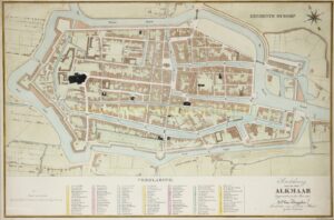

ALKMAAR AT THE START OF A CENTURY OF EXPANSION AND MODERNIZATION
“Grondtekening van de stad Alkmaar” [Ground plan of the city of Alkmaar], lithograph by Marcellin Jobard after the 1823 design by Staats Peterse van Diggelen. Coloured by a later hand. Size: (print) 42 × 63 cm (frame 81.5 × 101 cm).
This detailed plan depicts the city of Alkmaar shortly after the French Period (1795–1813) in The Netherlands. Surveyor Van Diggelen worked for the Cadastre, established by Napoleon in 1811 and continued after his fall in 1813 by the Kingdom of the Netherlands. Maps of this type served both administrative purposes (taxation, land registration) and practical ones (urban development, fortifications).
Alkmaar is shown here as a still-enclosed fortress town, surrounded by moats, bastions, and ramparts that largely retained their sixteenth- and seventeenth-century form. Within the walls, the map reveals a dense street network interspersed with canals, alleys, and courtyards. Key buildings and institutions are marked in black and listed in the legend below: churches, convents, hospitals, markets, and government buildings. Clearly recognizable are the Grote or Sint-Laurens church, the Weigh House, the Town Hall, and the various orphanages and charitable institutions that structured the city’s social and religious life.
The map reflects Alkmaar in a period of transition. In the eighteenth century the city, like many towns in North Holland, had experienced economic stagnation. After the French Period, Alkmaar gradually recovered as a regional centre. In the early nineteenth century, the city served as an administrative and market hub for the surrounding agricultural areas. The cheese market, which had existed for centuries, retained its position as a linchpin of regional trade and remained an important source of income and civic pride.
At the same time, Alkmaar’s military significance waned: the fortifications were still intact in 1823, but their function was greatly diminished. Whereas in the Eighty Years’ War they had played a crucial role in the defence of Holland, by the nineteenth century they were increasingly regarded as an obstacle to urban growth. The map therefore captures Alkmaar on the eve of a century in which the city would expand and modernize.
Price: Euro 1.250,- (incl. frame)