

Haarlem, Velsen, Beverwijk, Heemstede, IJmuiden – Soviet map, 1977
€1.250


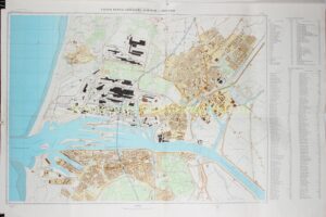


SECRET SOVIET MAP OF THE HAARLEM–VELSEN–BEVERWIJK–HEEMSTEDE–IJMUIDEN REGION
“ХАРЛЕМ, ВЕЛСЕН, БЕВЕРВЕЙК, ХЕМСТЕДЕ и ЭЙМЕЙДЕН”, colour offset print on three sheets, made in 1977 under the supervision of Colonel V.T. Viktorov. Size (each sheet): 78 × 114 cm.
With the collapse of the Soviet Union in 1991, the Cold War came to an end. An era of ideological confrontation and constant threat of war was over. In retrospect, it has become clear that the Soviet Union possessed better maps of the Netherlands (and many other Western countries) than the Dutch themselves. These Russian maps from the late 1970s reveal an unsettling level of detail.
From the 1940s onwards, the Soviet Union had begun systematically mapping the world. Cities were charted with unprecedented precision: even bus stops and government buildings can be identified. Several dozen such maps were produced for the Netherlands alone.
Maps like this one of the Haarlem–Velsen–Beverwijk–Heemstede–IJmuiden area were intended for operational planning. Government institutions, post offices, factories, barracks, airfields—all are clearly indicated in Cyrillic script. For many bridges, their dimensions and load-bearing capacity are specified, along with information on the navigability and width of the associated rivers and canals. The height of dams and dikes, types of crops, and road surfacing are also recorded. The map is marked “секретно” [secret].
In addition to the fact that many Western countries made topographic maps publicly available—sources that communist spies will undoubtedly have exploited—the Soviet Union had access to satellite intelligence from the 1960s onwards. Additional information was gathered through extensive espionage activities. It is highly likely that Soviet agents were active via the embassy in the Netherlands. Nor were they alone. In the 1950s, all truck drivers from Eastern Europe were screened by the Dutch intelligence services. This policy was later abandoned, but in the 1980s renewed warnings were issued about Ukrainian truck drivers loitering near military installations. At times, passenger aircraft from the Soviet Union also temporarily disappeared from Dutch radar. It later emerged that these aircraft had descended into low-level dives in order to photograph locations of interest.
Yet these maps were probably not created solely for the purpose of war. They also record specific information on crops, roadside vegetation, and the locations of facilities such as post offices—details that would appear superfluous if one were planning only a military offensive or even a devastating nuclear strike. Presumably this reflects the belief, maintained by the communist leadership in Moscow until the very end of the Cold War, that the West, too, would eventually fall to communism.
These maps enabled the Soviet authorities to gain a deeper understanding of the world beyond their existing borders. It was, after all, assumed to be only a matter of time before the Soviet Union would extend its control there as well. When that moment arrived, these maps would prove invaluable.
The extent to which the Soviet Union had mapped the world only became fully apparent after the collapse of the communist superpower in 1991. Although orders were issued from Moscow to destroy the maps, many nevertheless ended up in the West. Through Russian officers, they found their way into the hands of universities, collectors, companies, and even armed forces.
Reading the СПРАВКА (Spravka, explanatory memorandum) on the final sheet is a sobering experience:
The area is not presented as a collection of individual cities, but as a single, integrated strategic hub on the western edge of the Netherlands, in which seaports, industry, water management, and infrastructure are closely interconnected. The text reads as a military-geographical analysis in which the landscape is systematically assessed in terms of mobility, vulnerability, and military utility.
At the centre of this assessment is the North Sea Canal and the IJmuiden lock complex, explicitly described as an object of primary strategic importance. The Spravka provides precise data on the canal’s length, width, and depth, the construction of the locks, the harbour basins, and the quay walls. It becomes clear that the canal is not only an economic lifeline, but also a potential gateway to the Dutch hinterland and the port of Amsterdam. The Soviet analysis regards IJmuiden as a key position: whoever controls or disables this point directly influences maritime access to Western Netherlands.
The concentration of industry around IJmuiden, particularly the Hoogovens steelworks, receives strikingly detailed attention. The steel industry is described in terms of scale, production capacity, energy consumption, and transport connections. This is not neutral economic information, but an implicit identification of a high-value strategic target—essential to war production, heavily dependent on electricity, water, and raw-material supply, and therefore vulnerable to disruption. The presence of chemical installations, storage facilities, and transshipment areas along the canal is also explicitly noted.
The Spravka further analyses the road and railway network from a military perspective. Main roads and motorways are assessed for carriageway width, surfacing, and suitability for heavy traffic, directly indicating their importance for troop movements and logistics. Bridges and viaducts are described with attention to load-bearing capacity and construction type, implicitly marking them as both vital links and potential bottlenecks. Railway lines and marshalling yards in Haarlem, Beverwijk, and Velsen are presented as key connections between the coast, industrial zones, and the interior.
The water-management landscape plays a central role in the military assessment. Large parts of the area lie below or just above sea level and depend on dikes, pumping stations, and regulated water levels. The Spravka repeatedly emphasises the high groundwater level, the presence of peat and clay soils, and the limited load-bearing capacity of the ground outside the main roads. This means that large-scale movement of equipment is possible in many zones only along fixed infrastructure. At the same time, the text—without stating it explicitly—suggests that inundation and water control could serve as potential defensive or offensive instruments.
The cities themselves are not primarily described in cultural terms, but as spatial structures. Historic city centres with narrow streets and dense building patterns are distinguished from more modern extensions with wider roads and open layouts. This distinction is militarily relevant: older centres are implicitly regarded as difficult for vehicles to traverse, while newer districts offer better manoeuvring space. Building heights, the presence of industrial complexes on city edges, and the location of energy and water facilities are systematically noted.
Civil infrastructure likewise acquires a strategic dimension. Power stations, water supply systems, gas networks, hospitals, and communications infrastructure are identified as essential elements for the functioning of cities and industry. Their inclusion reflects a classic Soviet target logic: infrastructure critical to continuity, yet vulnerable to targeted disruption.
What stands out in the Spravka is that military barracks or NATO installations are scarcely mentioned explicitly. The strategic value of the region is not sought in visible military facilities, but in the combination of harbour, industry, infrastructure, and water management. This aligns with Soviet doctrine, in which disabling economic and logistical nodes was considered as important as neutralising troop formations.
Price: Euro 1.250,-