

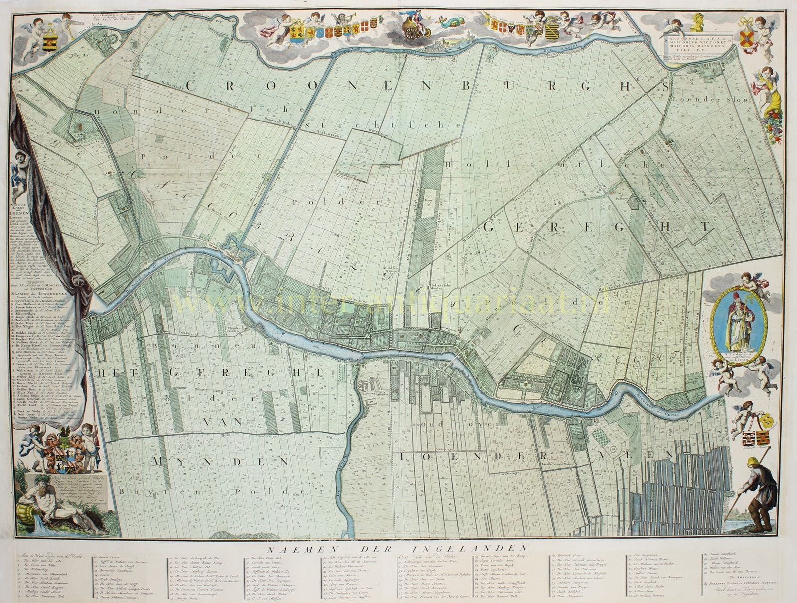

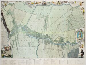
MOOISTE KAART VAN LOENEN AAN DE VECHT
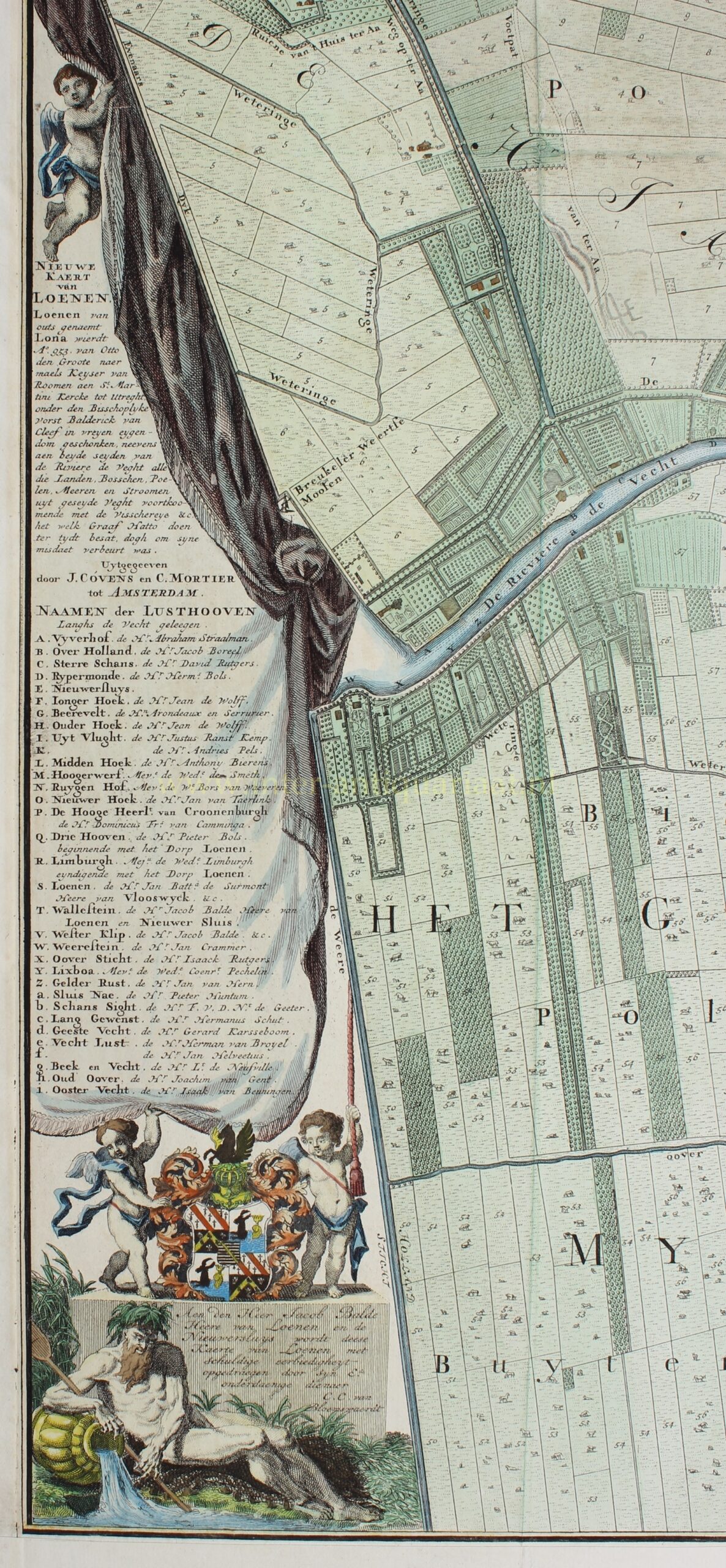
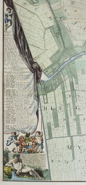
“Nieuwe kaert van Loenen” kopergravure vervaardigd door Kornelis Kooten van Bloemswaard, uitgegeven bij Johannes Covens & Cornelis Mortier te Amsterdam tussen 1726-1737. Later met de hand gekleurd. Afm. (kaart incl. strook met namen): 71 x 92 cm.
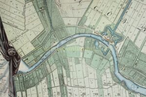
De grootste bloeitijd van de buitenhuizen in de Vechtstreek valt in de 18de eeuw. Deze sublieme Kaart geeft de situatie duidelijk weer voor het gedeelte van de Vecht-buitens tussen Breukelen en Vreeland, met centraal daarin Loenen. Maar de kaart – opgedragen aan Jacob Balde, Heer van Loenen – geeft niet alleen een zeer nauwkeurig beeld van de grondvorm van de huizen en tuinen, ook de percelen aan weerszijden van de Vecht, in het westen tot aan de Angstel en in het oosten tot halverwege de huidige Loosdrechtse Plassen, zijn heel precies in kaart gebracht.
De cijfers in de percelen corresponderen met de eigenaarsnamen (“Naemen der Ingelanden”) in de strook onderaan de kaart. Het is dus niet alleen een topografische, maar ook een pre-kadastrale kaart, die laat zien dat veel grond in bezit was van stedelingen. Deze eigenaars behoorden bijna uitsluitend tot de categorie van rijke Amsterdammers: Jacob Boreel, Lodewijk de Bas, Anthony Bierens, Andries Pels, walvisreder Jan van Tarelink, Maria Cristina de Geer, Gillis Graefflandt, Anthony Rutgers, etc., voor het grootste gedeelte bezitters van buitenplaatsen langs de Vecht. Hun landerijen lagen dikwijls achter hun buitenhuizen.
Vier nummers op de kaart geven bezittingen aan van de Ridderschap, Vicarie, Kapittel van St. Marie en “carthuysers tot Ceulen”. Van de 93 namen worden 48 voorafgegaan door het predikaat De Heer, Mevrouwe, Juffrouw de Weduwe, of Juffrouw. De overige eigenaren, zonder predikaat, waren van mindere stand. Meer dan de helft van de landeigenaren in de omgeving van Loenen behoorde toen dus tot de stedelijke aristocratie. De kaart laat ook zien dat zij tezamen veel meer dan de helft van de grond bezaten.
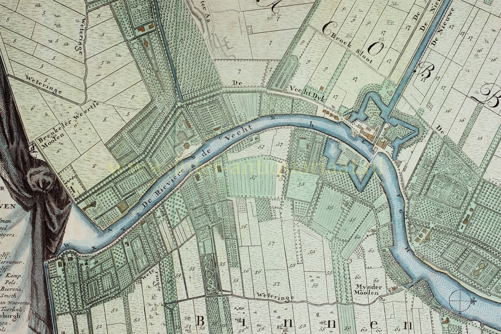
Het grondgebruik is aangeduid door vee en hooioppers (= wei en hooiland), arcering (= bouwland) en boompjes (geriefhout?), die in de percelen zijn getekend. De geometrisch aangelegde siertuinen van de buitenplaatsen langs de Vecht contrasteren hiermee. De bebouwing die niet tot het buitenplaats complex behoort, zoals bijvoorbeeld de boerderijen, is in de opstand weergegeven.
Door de vele details raakt men niet snel uitgekeken op deze kaart, die een rijke bron van informatie vormt. Rechtsonder is een begin van het ontstaan van trekgaten en legakkers te zien nabij de Lambertskade als gevolg van het slagturven, heel toepasselijk is daarbij een vervener met zijn baggerbeugel afgebeeld.
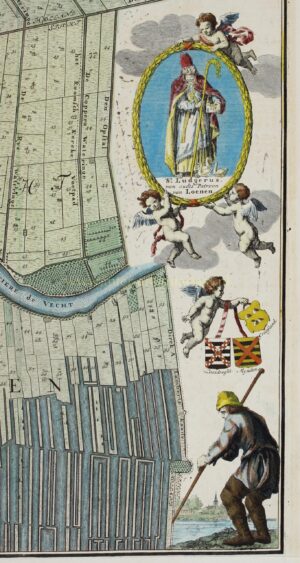
De bankier en koopman Jacob Balde, die de kaartvervaardiging waarschijnlijk voor een groot deel heeft gefinancierd, werd Heer van Loenen en Nieuwersluis in 1712 en overleed in 1730. Hij woonde op buitenplaats Westerklip en bezat ook de aangrenzende buitenplaats Wallestein; op de kaart aangeduid met de letters v en t. In de lijst van ingelanden komt hij voor onder nr. 38.
Hoe deze kaart, die van zeer groot vakmanschap getuigt- zowel wat betreft de landmeetkundige en topografische terrein opname als het uiteindelijke graveerwerk -, tot stand kwam, is niet bekend. Kornelis Kooten van Bloemswaard, die de kaart heeft opgedragen aan Jacob Balde en om die reden als auteur is te zien, is als kaartmaker een volkomen onbekende. Zijn naam komt voor in enkele archiefstukken van de Heerlijkheid Kroonenburg. Hij was schepen van Loenen, blijkt oudheidkenner te zijn geweest en bevriend met enkele leden van de familie Balde. Tot zijn dood in 1749 heeft hij zich intensief met de Loenense archieven beziggehouden. Deze belangstelling voor de oudheid en de lokale geschiedenis komt op de kaart duidelijk naar voren in de decoraties: “St. Ludgerus van oudts patroon van Loenen” is rechts afgebeeld, rechtboven de (Romeinse) “Steene Tombe gevonden tot Loenersloot en het hooft in Mynden” en bovenaan de wapens van de vroegere bezitters van Kronenburg en Loenen. Het profiel daartussen is waarschijnlijk gebaseerd op de gravure van het kasteel Kronenburg en het dorp Loenen uit 1670 naar A. Rademaker (uitgegeven in 1725).
Het is echter onwaarschijnlijk dat Van Bloemswaard de kaart geheel zelfstandig heeft gemaakt. De aanduiding Nieuwe kaart van Loenen slaat mogelijk op een oudere kaart, die door hem is bijgewerkt en aangevuld op verzoek van Jacob Balde.
De Nieuwe kaart van Loenen is een van de hoogtepunten uit de 18de-eeuwse (commerciële) cartografie van de Vechtstreek. Hoewel Van Bloemswaard z’n werk waaromstreeks 1726 heeft verricht (dit jaartal staat bij het wapen van Jacob Balde boven aan de kaart) wordt er vanaf 1737 voor de kaart geadverteerd in de Amsterdamsche Courant.
Literatuur:
- Van Lutterveld (1948, p.17, 50, 90, 142 e.v.)
- De Vechtstreek – Oude kaarten en de geschiedenis van het landschap door Marijke Donkersloot-de Vrij (1985, p. 90-92).
Prijs: Euro 7.500,-