

West Friesland – Hendrik de Leth, 1732
€1.950
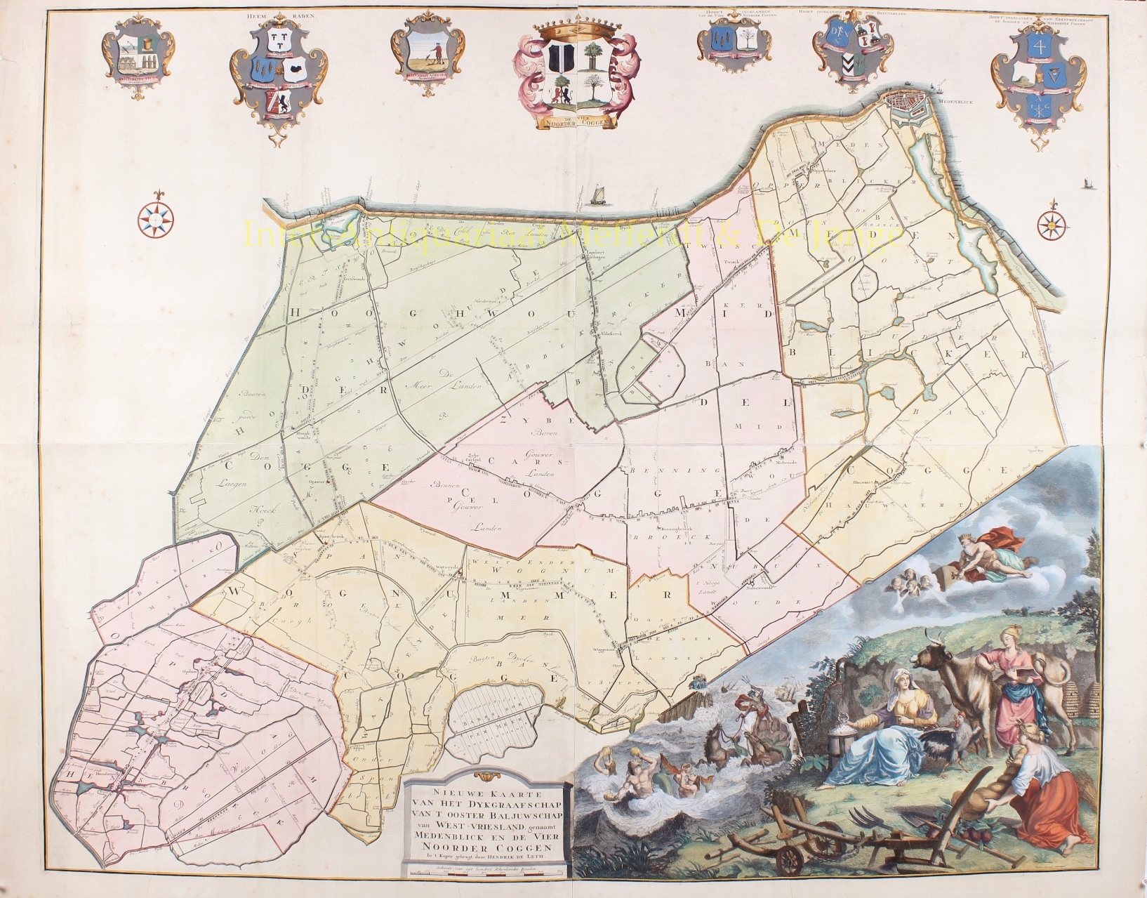


“Nieuwe Kaarte van het Dijkgraafschap van ‘t ooster Baljuwschap van West-Vriesland, genaamt Medenblick en de Vier Noorder Coggen.” [New Map of the Dijkgraafschap of the Eastern Bailiwick of West Friesland, named Medemblik and the Four Northern Koggen]. Copper engraving made by Hendrik de Leth in Amsterdam in 1732, after the design by cartographer Pieter Straat. Coloured by a later hand. Four mounted sheets together measuring 93 x 114 cm.
In the Middle Ages, West Friesland was divided into four “ambachten ” (administrative units above the local level) that likely existed before West Friesland was conquered by the Counts of Holland. These ambachten were further divided into several so-called “koggen,” which were subdivided into “bannen” (villages). The “Four Northern Koggen” comprised the Hoogwouder Kogge, the Middelkogge, the Zeekogge or Medemblik Kogge, and the Wognumer Kogge. After the West Frisians were subdued by count count Floris V and finally by count John I, bailiwicks were established that had high jurisdiction and were tasked with overseeing the dikes. Together with Drechterland, the Four Northern Koggen formed the Eastern Bailiwick of West Friesland. However, this bailiwick was short-lived: in the early 15th century, much of the West Frisian countryside was divided into “rural towns” with city rights, with the remaining areas placed under the jurisdiction of existing cities.
The section of the Westfriese Omringdijk (West Frisian Circular Dike) under the management of the Four Northern Koggen was overseen by the superintendents of the Four Northern Koggen. Initially, there were twelve, later six delegates from the Dutch cities of Haarlem, Amsterdam, Alkmaar, Hoorn, Enkhuizen, and Medemblik. The creation of the ambacht itself as a dike reeve district dates to 1503: in that year, the “Oosterdijkgraafschap” [Eastern Dike Reeve District] was split into the Four Northern Koggen and Drechterland, each with its own Dijkgraaf.
Printer and publisher Hendrik de Leth advertised this map in the Amsterdamsche Courant on December 23 and 30, 1732. It described the map as “a new accurate Map of the Dijkgraafschap and Eastern Bailiwick of West Friesland, called Medemblik and the Four Northern Koggen, being the Ambacht most affected by the plague of worms.”
In the early 1730s, the West Frisian population was alarmed by the voracity of a mollusk 20 to 40 cm in length. This creature likely arrived in the hulls of ships and found an ideal habitat in the hundreds of thousands of wooden dike posts in the Netherlands. This shipworm attacked the wooden structures of the surrounding dike. In the decades before 1730, thousands of wooden posts had been driven into the ground to break the waves during storms. Coating them with tallow, resin, and printer’s ink proved ineffective.
To stop the shipworm’s activities and reduce the risk of dike breaches, it was decided to replace the posts with stone cladding on the outer side of the dike. The many tons of stone were imported from Belgium, Germany, Denmark, and Norway. In Drenthe, even megalithic tombs (hunebedden) were destroyed for this purpose. Combating the shipworm was a massive undertaking, with stone transport continuing until about 1800.
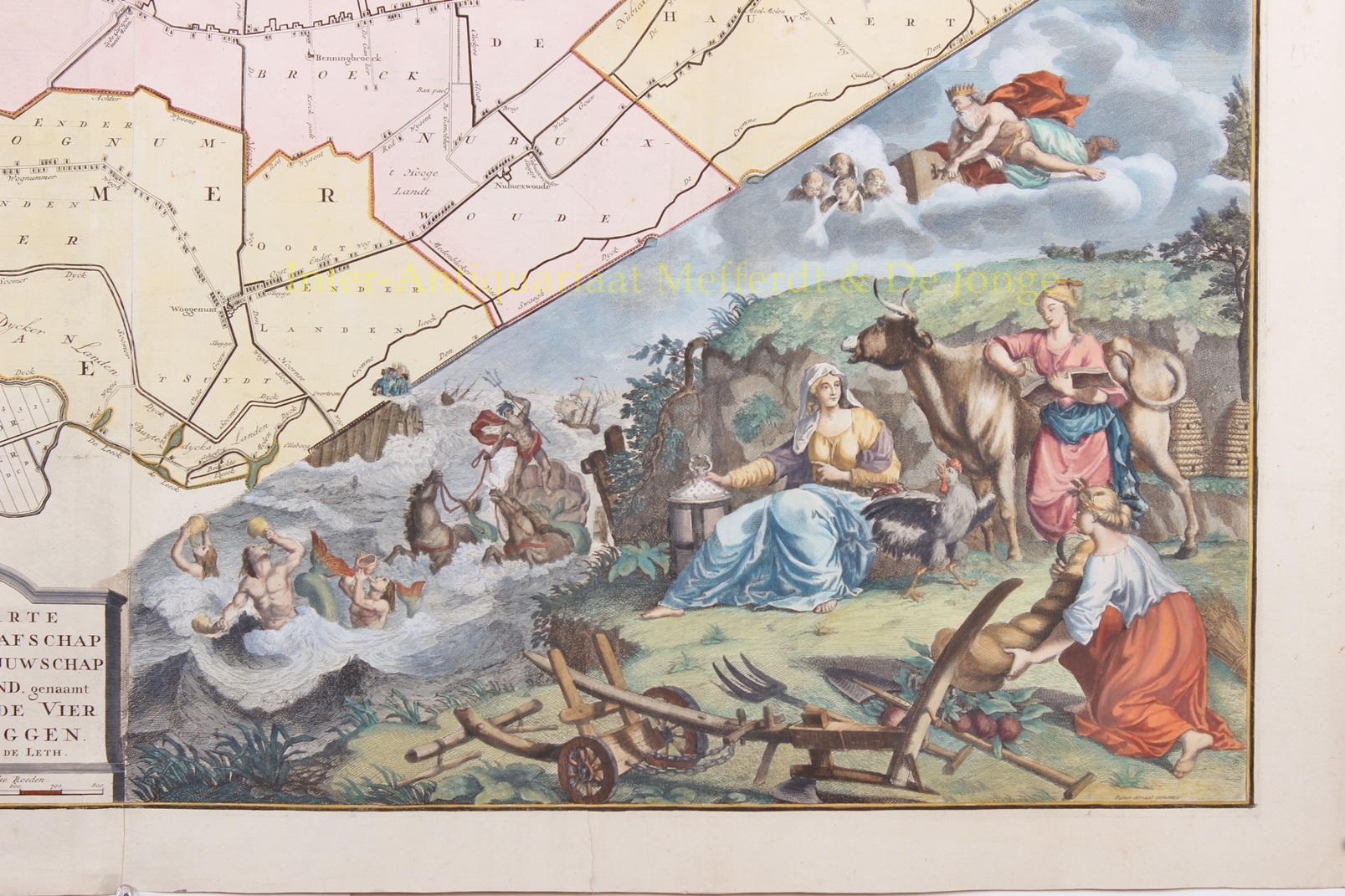
In the lower right corner, the map artistically depicts the daily concerns of the inhabitants. For example, it shows the Four Northern Koggen Dike, which could break during a wild sea. Neptune and King Aeolus, gods of the sea and winds, are shown causing trouble in the background with ships in distress. If the inhabitants are vigilant (symbolized by a rooster), diligent (beehives), cultivate their land (plow, pitchfork, spade), and care for their livestock (cow), they will reap a harvest (sheaf of wheat) and enjoy the “horn of plenty.”
Price: Euro 1.950,-