

Zeeland – Willem Blaeu, 1640-1655
€650


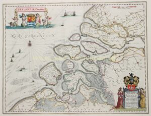

THE COUNTY OF ZEELAND
“Zeelandia Comitatus,” copper engraving published by Willem Blaeu as part of his Atlas Novus between 1640 and 1655. With original hand colouring. Verso: Dutch text. Size: 38 × 49.5 cm.
This map by Willem Jansz. Blaeu is still essentially based on Jacob van Deventer’s survey, but much has been added. The towns are shown as small plans with their fortifications and bastions. In Zeeuws-Vlaanderen the areas inundated during the military operations are indicated: Aardenburg and Axel appear as islands in the flooded land, and we see a large number of sconces in this region, which at the time formed the front line between the Dutch States’ and Spanish armies. Yet there is also evidence of land reclamation, for southwest of Terneuzen part of the flooded area of the Braakman has been newly enclosed by dikes. On the shore lies Fort Mauritius, constructed in 1586 by Prince Maurice to protect these new polders from the Spaniards, who had occupied the town of Philippine on the opposite side of the Braakman. After 1633, when Philippine was captured, the fort lost its purpose and fell into disuse soon thereafter.
East of Tholen, across the Eendracht, the sconces are shown and named in the inundated area. Around the Zeeland islands the dikes are indicated; the Westkapelle sea dike is depicted in detail with groynes. The South Holland islands, however, are not given any groynes.
A portion of drowned Noord-Beveland, with Colijnsplaat and Kats—reclaimed again in 1598 and 1616—is indicated as such, although the shape of this area does not correspond to reality.
Very small in size is Sint Joostland, which had only recently been reclaimed in 1631. Curiously, the land of Borssele, diked in 1616, is still shown as submerged; and since the map was never updated in any of the years Blaeu continued to publish it, this outdated depiction persisted for decades.
In the lower right corner, the map is dedicated to the poet and pensionary of the city of Middelburg, Simon van Beaumont (1574–1654). He represented the States of Zeeland in the States General and, as an extraordinary envoy, undertook diplomatic missions to Poland, Denmark and Sweden.
In the upper left is the coat of arms of Zeeland beneath a canopy with the title. The coat of arms and the canopy are supported by nereids.
Literature: Blonk – “Zelandia Comitatus. Geschiedenis en Cartobibliografie van de provincie Zeeland tot 1860”, no. 31
Price: Euro 650,-