

Angola, South Africa, Cape of Good Hope – Reinier & Josua Ottens, c. 1730
€750
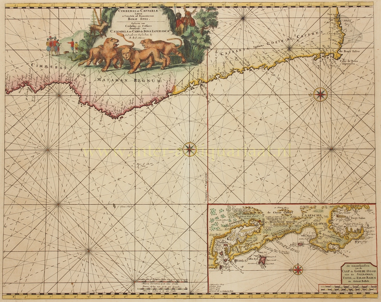

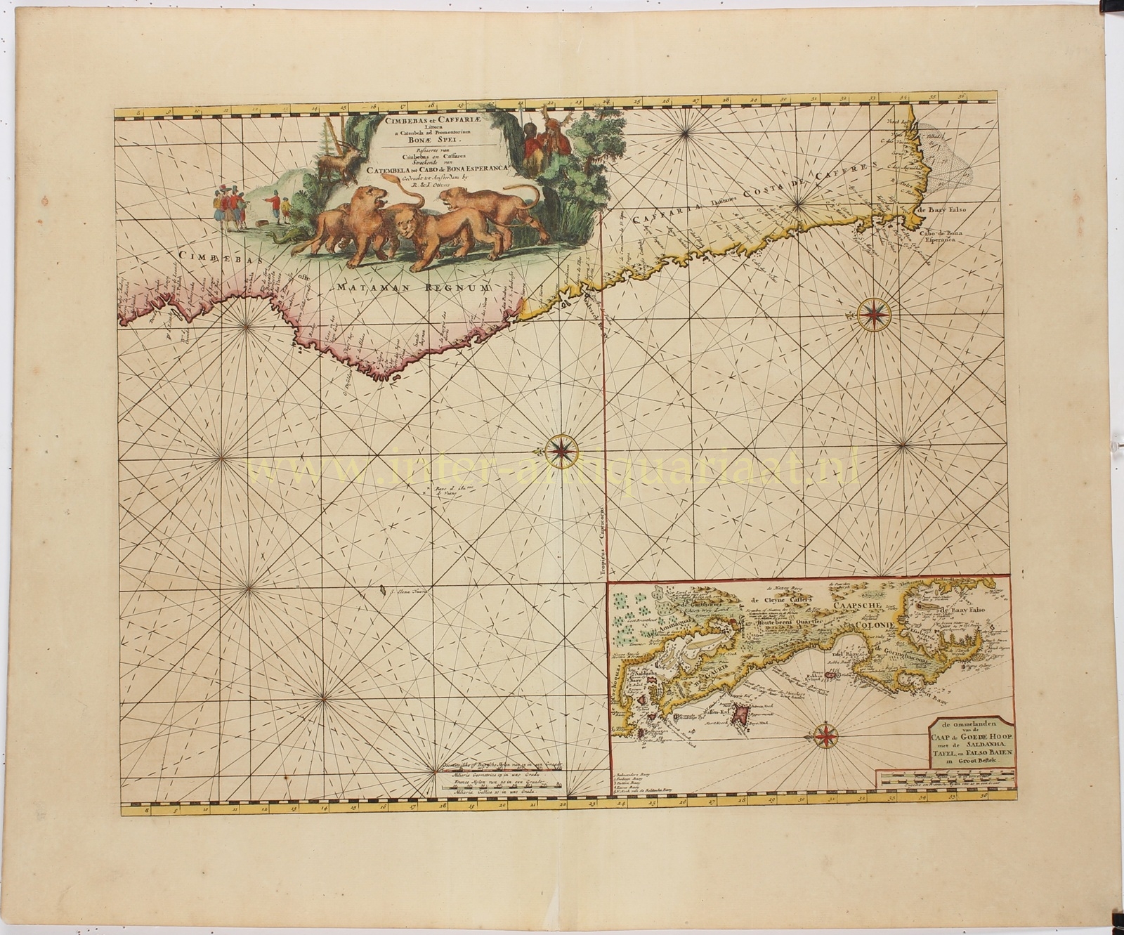


SEA CHART OF THE COAST OF SOUTH AFRICA WITH INSET OF THE CAPE OF GOOD HOPE
“Cimbebas et Caffariae Littora a Catenbela ad Promontorium Bonae Spei“ [The coasts of Cimbebasia and Kaffraria from Catumbela to the Cape of Good Hope]. Copper engraving made around 1730 by Reinier and Josua Ottens in Amsterdam. With original hand colouring. Size: 43.5 × 55 cm.
This fine sea chart depicts the southwestern coast of Africa from Catumbela (in present-day Angola) to the Cape of Good Hope. Rich in maritime history and crucial during the Age of Discovery, the region is rendered with ornate detail, emphasizing both its exotic allure and its strategic significance to Dutch seafaring.
The map encompasses regions inhabited by the Khoikhoi and San peoples, among others. Trading centres such as Catumbela formed part of the extensive network for the trade in gold, ivory, and slaves that linked the African interior with the coast and beyond.
In the 17th and 18th centuries, this region was a vital link in the Dutch maritime route for the spice trade and other commercial enterprises between Europe and Asia. The Dutch East India Company (VOC), founded in 1602, dominated these routes and established several trading posts and colonies along the African coast. The Cape of Good Hope, in particular, was of great importance as a replenishment station for ships navigating the waters between Europe and Asia. Explorers such as Bartolomeu Dias, who first rounded the Cape in 1488, and later Dutch navigators, charted these waters with increasing precision, enhancing their accessibility and strategic value. The Dutch colony of Cape Town, founded in 1652, soon grew into a major centre of Dutch influence. It attracted European settlers and rapidly developed into a hub of trade and communication in the region. Meanwhile, the Portuguese had established settlements in Angola and Mozambique and maintained a strong foothold in coastal trade networks.
In the second half of the 17th and the first half of the 18th century, European commerce in the region was largely driven by the transatlantic slave trade. Dutch and Portuguese ships were among the most active participants, deporting millions of Africans to the Americas. The southwestern coast of Africa was a key source region, where large numbers of people were captured and enslaved by local rulers and traders. Alongside the slave trade, European commerce in this period also included the exchange of ivory, gold, and spices. Elephant ivory, in particular, was highly sought after by the Dutch, prized in Europe for the production of luxury goods and fine carvings.
The elaborate title cartouche at the top features lions, a gazelle, and an unidentifiable reptile, along with European traders and local men with spears and an imposing headdress.
The inset map at lower right provides a more detailed representation of the environs and coastline of the Cape of Good Hope.
Price: Euro 750,-