

Frankfurt am Main and Offenbach – Soviet military map, 1978
€1.250


SECRET SOVIET MILITARY MAP OF FRANKFURT AM MAIN AND OFFENBACH, 1978
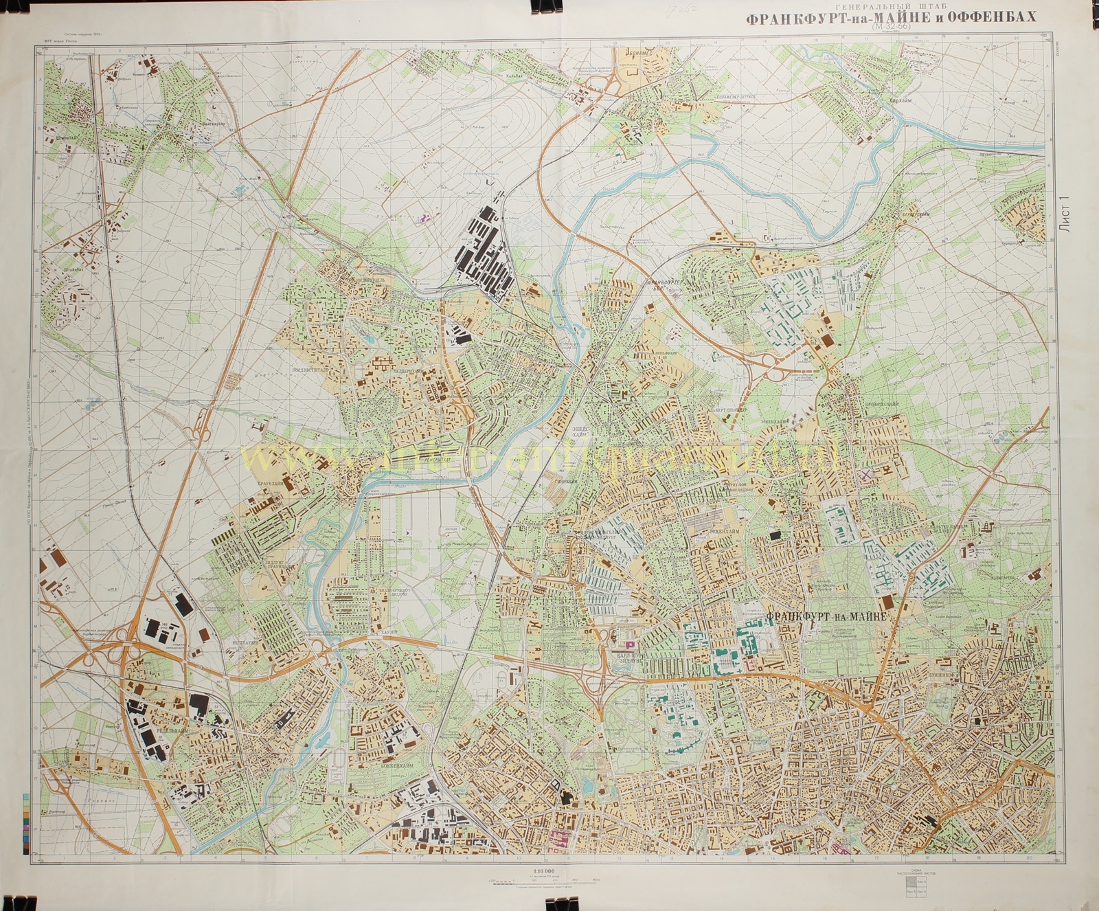
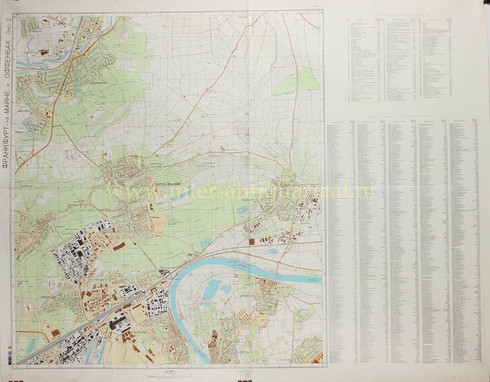
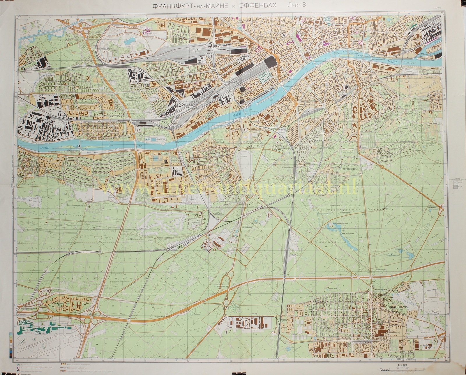
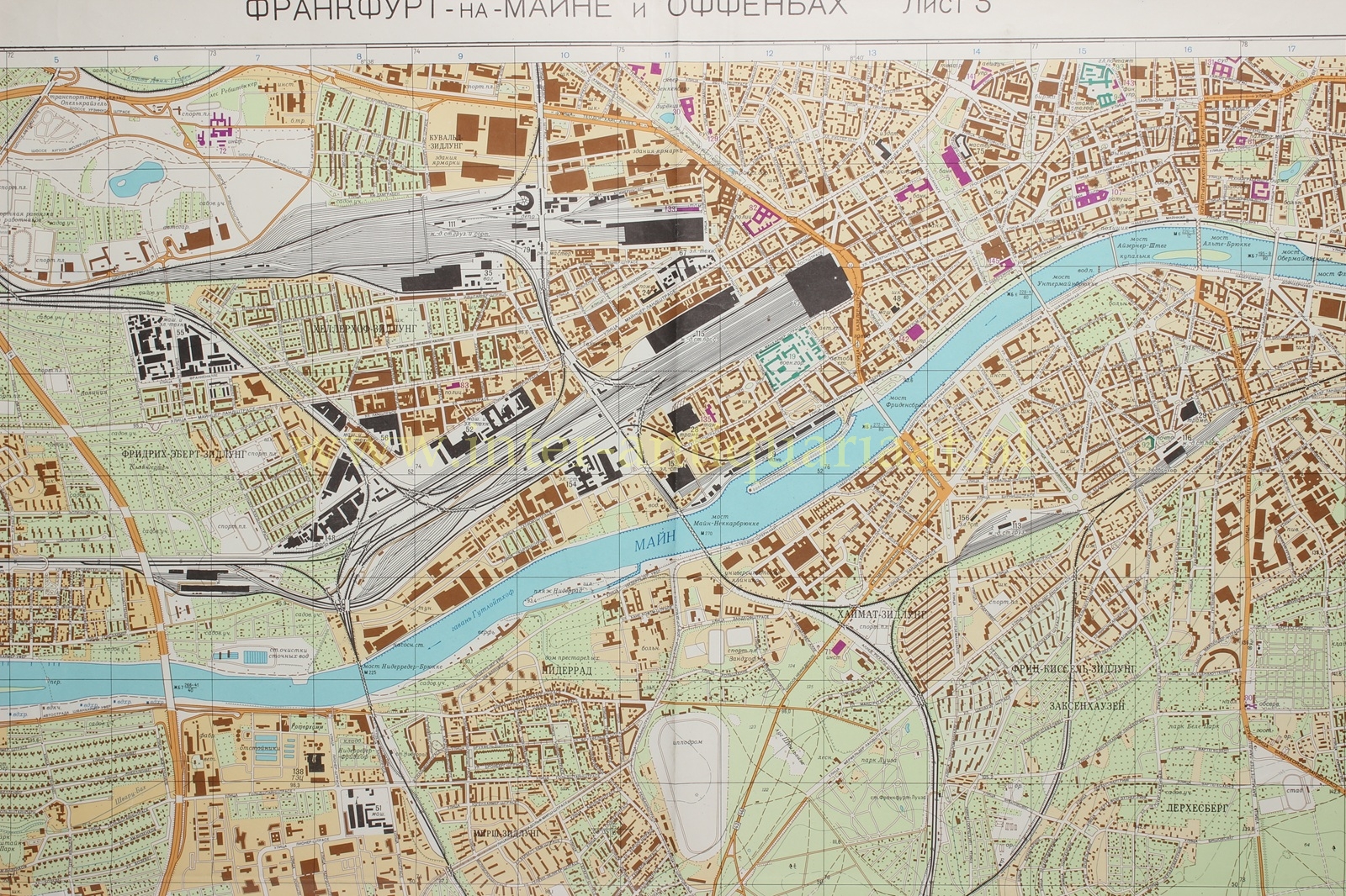
“ФРАНКФУРТ-НА-МАЙНЕ И ОФФЕНБАХ” [Frankfurt-on-the-Main and Offenbach], colour offset print on four sheets, issued in 1978 by the Military Topographic Directorate of the General Staff of the Soviet Union. Size: two sheets approx. 82 × 71.5 cm and two sheets 82 × 102 cm.
This rare four-sheet map of Frankfurt am Main and Offenbach forms part of the secret cartographic production of the Soviet Union during the Cold War. From the 1940s onward, the Military Topographic Directorate of the General Staff systematically compiled a global mapping corpus, in which key urban and industrial centres in Western Europe were recorded with remarkable precision. Intended for operational planning, logistical analysis, and strategic orientation, these maps are distinguished by their combination of topographical accuracy and a distinctly functional reading of the landscape.
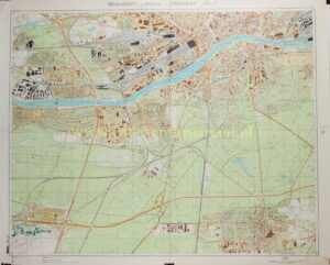
Together, the four sheets provide a comprehensive view of Frankfurt am Main and the immediately adjacent city of Offenbach, situated along the River Main, approximately 30 kilometres upstream from its confluence with the Rhine. In Soviet analysis, Frankfurt is characterised as one of the principal industrial, financial, and logistical hubs of the Federal Republic, of clear international importance. The city forms the core of the extensive Rhine–Main agglomeration, surrounded by a belt of industrial satellite towns.
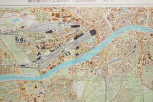
The River Main occupies a central position in the composition and is not only rendered with topographical precision, but clearly understood as a structuring element within the urban system. Bridges, riverbanks, and port installations are shown in detail, with the river interpreted both as a transport artery and as a potential obstacle. The inland ports of Frankfurt—including the Osthafen and Westhafen—are delineated with quays, cranes, and storage facilities, illustrating the scale of goods handling; the port of Offenbach forms part of this network.
The city’s transport apparatus is among the most elaborately depicted features. Frankfurt appears as one of the principal railway nodes of West Germany, with a dense network of lines, yards, marshalling facilities, and workshops directly connected to industrial complexes. The road network complements this with a finely articulated system of main roads and motorways linking the city in all directions. Frankfurt Airport, prominently shown with long runways and extensive supporting infrastructure, underscores the city’s international role and is explicitly noted as suitable for intensive civilian and military use.
The urban structure is presented as historically evolved and heterogeneous. The centre, located on the right bank of the Main, coincides with the financial and administrative core and is encircled by a ring of boulevards laid out on the site of former fortifications. Here, a high density of development ranges from older low-rise masonry buildings to modern high-rise structures. The presence of skyscrapers and large banking and office complexes marks Frankfurt’s role as a financial centre. Beyond the centre, residential districts display a variety of layouts, from older compact fabrics to large-scale modern expansions.
Particularly notable is the systematic recording of industrial and logistical capacity. Frankfurt and Offenbach are described as centres of mechanical engineering, electrical industry, and chemical production, complemented by a broad spectrum of manufacturing, from vehicles and precision instruments to plastics and pharmaceuticals. Nearby industrial zones at Höchst, Rüsselsheim (Opel), and Hanau are explicitly incorporated into the analysis. Not only civilian production is recorded, but also sectors of potential military relevance, including aviation technology, electronics, and the nuclear industry. References to heavy water facilities and the presence of nuclear research installations underscore this strategic perspective.
Particularly noteworthy is the explicit reference, in the accompanying Soviet Spravka, to the presence of United States military installations in and around Frankfurt. American barracks, command facilities, and logistical depots are identified and described as integral components of the broader military landscape of the region. Their inclusion underscores the intelligence-driven nature of these maps: not merely recording the physical fabric of the city, but systematically cataloguing elements of strategic relevance within the NATO sphere. In this respect, the map offers a rare insight into how Soviet military planners assessed Western urban environments—not only as centres of production and transport, but also as zones of allied military presence and potential operational significance.
Urban and social infrastructure is likewise documented in detail. Government buildings, communications facilities, research institutes, and universities—including the Goethe University—are precisely located. The map further records energy supply, water management, and gas distribution, including international connections such as the supply of natural gas from Groningen. Even seemingly secondary elements—vegetation, soil conditions, and relief—are systematically included, partly in relation to terrain passability.
The surrounding landscape is treated not as backdrop but as an integral component of the whole. The generally flat to gently undulating terrain, intersected by rivers and infrastructure corridors and bounded by the Taunus range, is analysed in terms of mobility and obstacles. Soil types, water levels, and seasonal variations are explicitly noted, reflecting the importance of ground conditions for military operations.
This map exemplifies the characteristic Soviet approach to cartography, in which the city is read as an integrated system of infrastructure, production, and control. The combination of scale, detail, and analytical depth makes it an exceptional document of late twentieth-century military geography.
Only after the dissolution of the Soviet Union in 1991 did the full scope and sophistication of this cartographic programme become clear. Despite attempts at destruction, maps such as this reached the West, where they are now valued as rare and compelling artefacts of a period in which urban space was analysed and recorded not only in civil, but also in strategic terms.
Price: Euro 1.250,- (4 sheets)