

Engeland, east coast and Thames Estuary – Greenville Collins, c. 1693
€850


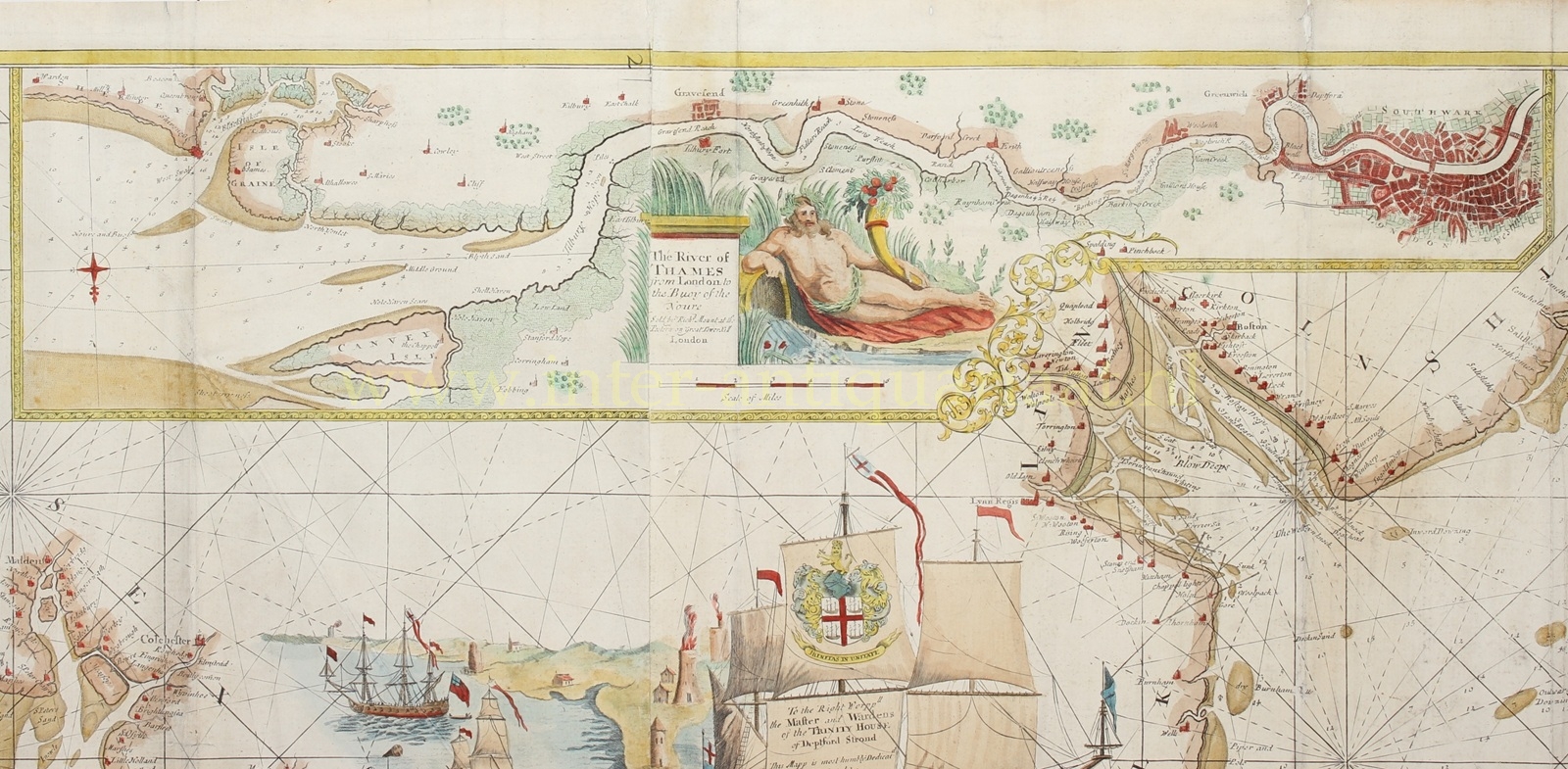


NAUTICAL CHART OF THE NORTH SEA FROM THE THAMES ESTUARY TO THE WASH
“The River of Thames from London to the Buoy of the Noure.” Copper engraving on two mounted sheets published around 1693 “at the Postern on Great Tower Hill” by Richard Mount as part of the “Great Britain’s Coasting Pilot” by Greenville Collins. Coloured by a later hand. Size: approx. 60 x 94 cm.
In the Spring of 1681, Captain Greenville Collins (c. 1643-c. 1693) gained King Charles II‘s preferment to survey the country’s coasts. His surveying was carried out under the supervision of Trinity House, who also supported the project with financial contributions. (Hence the dedication of the map to the ” Right Worshipful Master and Wardens of Trinity House at Deptford Strond”.)
Collins eventually spent seven years on the survey, at first on the HMS Merlin and HMS Monmouth, later aboard the Martin and Younge Spragge. As well as his own observations, he likely included existing charts and seamen’s sketches and notes, and published charts as they were completed. Collins began gathering engraved copper plates with which to print his charts while he was engaged on the survey, and continued gathering more plates in the years following. In 1693, he finally published his results in a folio volume of two parts, Great Britain’s Coasting Pilot, containing sailing directions, tide tables, coastal views and about forty-nine charts. It was the first original sea atlas to be produced by an Englishman.
The charts were not completely accurate, but with all their shortcomings they were an enormous advance on anything before them, and entitled Collins to rank not only with the earliest, but with the best of English hydrographers. The work covered England and Scotland, and though Collins proposed a further study to cover Ireland, the plan came to nothing. Collins recorded that he had spent £40 on instruments, and charged £80 for the 120 manuscript maps he delivered. With his claim for expenses set at £200 per annum, and his wages of £394 10s., he claimed a total of £1914 10s. for his work, which was eventually paid in arrears. The cost was more than three times the original estimate.
This beautifully decorated and highly detailed coastal chart sea chart shows (orientated towards the west) the east coast of England from the town of Dover to the Humber estuary, including the coastlines of north Kent, Essex, Suffolk, Norfolk and Lincolnshire.
A wind rose, depth soundings and rhumb lines are there to aid navigation and there’s an inset of the Thames showing it in greater detail, embellished with a depiction of “Old Father Thames” holding a cornucopia at the source of the river.
Price: Euro 850,-