

Brazil – Matthäus Seutter, ca. 1730
€375
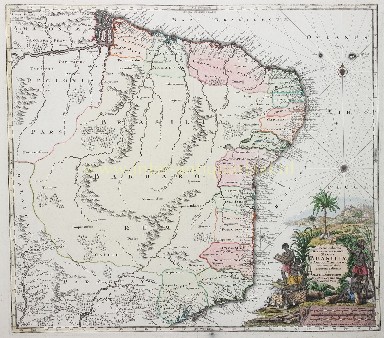


BRAZIL IN THE FIRST HALF OF THE 18TH CENTURY
“Recens elaborata mappa geographica Regni Brasiliae in America Meridionali maxime celebris.“ [Newly composed geographical map of the most celebrated kingdom of Brazil in South America.] Copperplate engraving made by Matthäus Seutter, published ca. 1730 in Augsburg. With original hand colouring. Size: ca. 50.8 x 58.4 cm.
This finely executed map of Brazil is based on Joan Blaeu‘s “Nova et Accurata Totius Brasiliae Tabula” from circa 1650. Both the geographical scope and the content are nearly identical, clearly demonstrating that in the intervening eighty years virtually no noteworthy progress was made in mapping the Brazilian interior.
The map covers the area from the mouth of the Amazon to São Paulo and from the Atlantic coast deep into the interior towards Paraguay. Parts of Paraguay are also included.
We see speculative mountain ranges, vast forests, and indications of indigenous population groups such as the Maridiocnysyams, Tupinambás, and Wayanawasons. In the upper left appears the mythical Lake Parima (“Lacus Parima”), connected to the legend of El Dorado, the supposed golden city that fascinated European explorers for centuries.
Along the coast, the Portuguese captaincies are carefully named, as are numerous towns, ports, and rivers. The economic significance of the coastal regions is further emphasised by the large title cartouche in the lower right. Here we see enslaved Africans processing sugarcane. Sugar was the driving force behind the Brazilian colonial economy in the seventeenth and eighteenth centuries. The chest of conical sugar loaves refers to the export of refined sugar, which was shipped from Brazil to Europe in this form.
Cartographer and publisher Matthäus Seutter (1678–1757) was one of the most important map publishers in the German-speaking world in the eighteenth century. Seutter initially worked as an engraver for Jeremias Wolff in Augsburg and trained in the circle of Johann Baptist Homann in Nuremberg. Around 1717 he founded his own publishing house, which would grow into one of the most productive cartographic enterprises in Europe. In 1731, Emperor Charles VI granted him the title of “Kaiserlicher Geograph” (Imperial Geographer). His maps often combine existing Dutch and French cartographic sources with a German Baroque aesthetic, rich in ornament, colour, and decorative detail.
Price: Euro 375,-