

Dutch Brazil – Joan Blaeu, c. 1662
€2.350

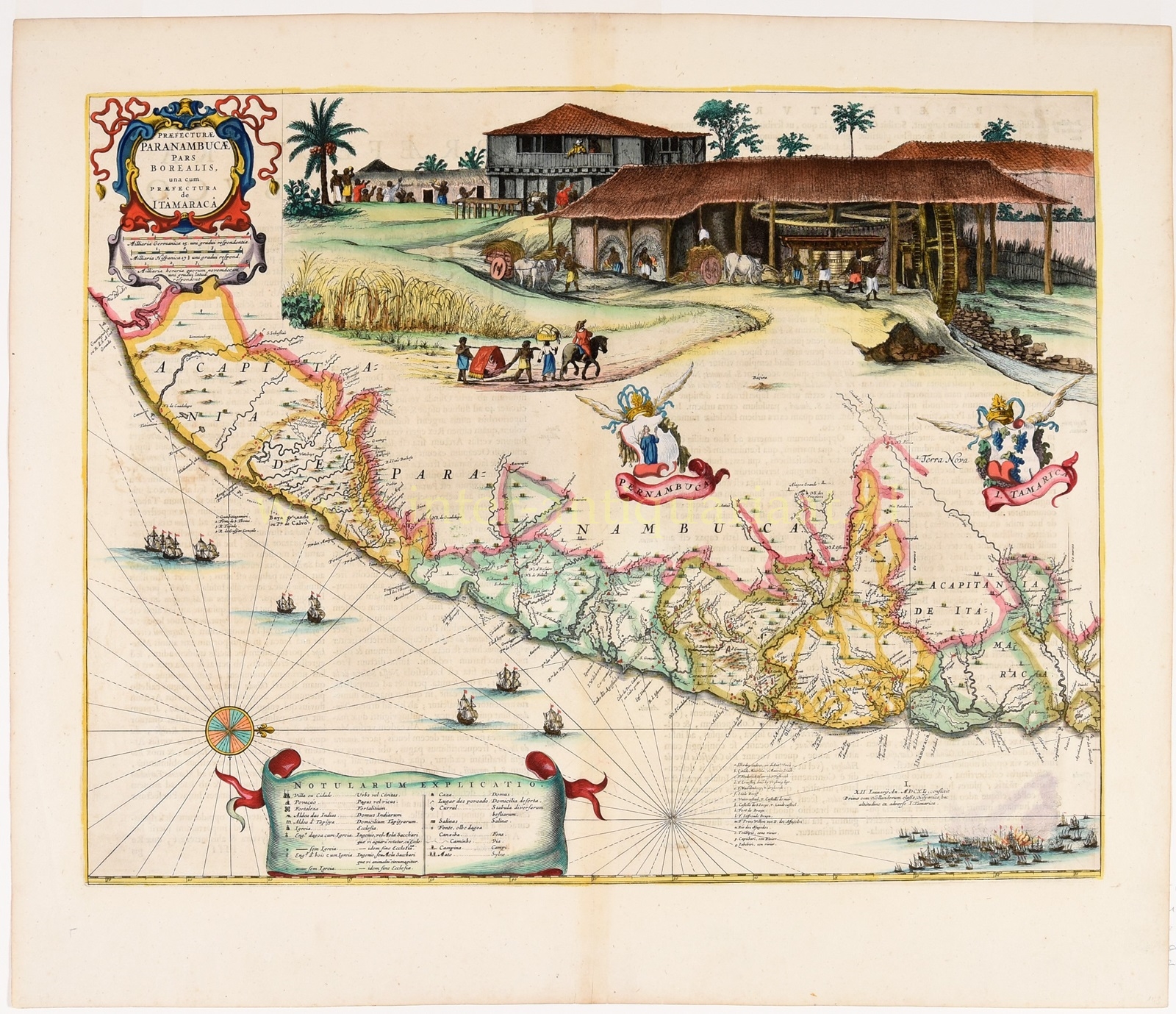
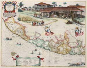
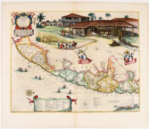
“Praefecturae Paranambucae pars Borealis, una cum praefectura de Itâmaracâ“ copper engraving after the design by Georg Marcgrave and Frans Post and published Joan Blaeu around 1662 as part of his “Atlas Maior”. Coloured by a later hand. Size: 41,5 x 53,4 cm.
Between 1630 and 1654, part of the northeastern coast of Brazil was under the control of the Dutch West India Company (WIC). For a significant part of this period (1636-1644), John Maurice of Nassau was the governor-general of Dutch Brazil. He aimed to make this region the center of the WIC. Consequently, he earned the nickname “the Brazilian”. (Nowadays, there is considerable debate about John Maurice due to his role in the slave trade and sugar production in Brazil.) The Mauritshuis, which he had built after returning to the Netherlands, was also called the Sugar Palace because of his involvement in sugar production and trade.
To gain a thorough understanding of the geography, culture, and especially the economic potential of the area, John Maurice invited a group of scientists and artists to Dutch Brazil to study, explore, and document the land. The German astronomer, naturalist, and cartographer Georg Marcgrave (1610-1644) was among them. In 1643, he created a completely new map of Dutch Brazil based on expeditions conducted between 1640 and 1643. This map was first published in 1647, in four sheets by Joan Blaeu in Amsterdam.
Marcgrave’s map consistently depicted only a narrow strip of land along the coast. Which is not surprising, as Dutch authority did not extend far into the interior. This engraving shows the so-called ‘captaincies’ Pernambuco and Itamaraca. The division of Brazil into captaincies was devised by the Portuguese to improve the governability of the area. The Portuguese government granted the captaincies to private individuals for administration.
Joan Blaeu included Marcgrave’s maps in his atlas, but to enhance the liveliness of the maps and fill the empty spaces in the interior, Blaeu added Brazilian scenes from landscape painter Frans Post. On this particular map, we see a sugarcane plantation in operation. At the bottom of the map, the naval battle between the Dutch and the Portuguese in 1640 is depicted.
The captaincy of Pernambuco, with Olinda as its capital, was the most economically important district due to its many sugar plantations. The port of Olinda, Recife, was strategically located and well-defended against potential enemies, being squeezed between a reef on one side and a difficult-to-navigate river on the other.
When governor Maurice arrived in Pernambuco, he first had Olinda destroyed and then built Mauritsstad nearby as a new administrative center. On the larger neighboring island of Antonio Vaz, fortifications and housing were built because Recife soon became overcrowded. The city had the first bridge in the New World.
In 1644, John Maurice left Dutch Brazil. A High Council was established to continue governing the area. However, the Dutch momentum had passed. The Dutch were no longer able to withstand the Portuguese and soon had to relinquish territories. In 1654, Recife, the last Dutch settlement, was sold to Portugal for salt and money.
Blaeu first published this map as part of Caspar Barleus‘s “Rerum per octennium in Brasilia” in 1647. By the time the Atlas Maior was published in 1662, Dutch control in Brazil had essentially ended.
Price: Euro 2.350,-