


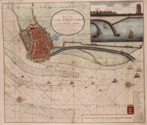
“Nieuwe afteekening van alle de banken, canaalen, tonnen en dieptens. Geleegen voor de stad Enkhuysen in de Zuyder Zee. Waar in aengeweesen word, hoedanig men, uyt de stad nae de Vuur Toren door het Voor Land gevoeglyk kan maken een nieuwe zee haven.” Copper engraving made by Gerard van Keulen after the design of Jan Belkmeer, published around 1720 in Amsterdam. Colored by a later hand. Size: approx. 50 x 59 cm.
Chart of the sandbanks off Enkhuizen with the projected new harbor designed by Petrus Eggerts. In the upper right corner an inset map with the imagined mouth of the new harbor and the town hidden behind the Noorderdijk, also the approx. 16m high lighthouse can be seen.
To counteract the silting of Enkhuizen’s seaport, a plan was made around 1700 to dig a channel outside the dike from the harbor to deeper water. To implement this project, a “Compagnie van Commercie, Navigatie, Assurantie, Visscherij etc.” [Company of commerce, navigation, insurance, fishing etc.] was to be founded with an initial capital of 20 million guilders. For this purpose, shares were issued in 1720. That this came to nothing is proven by the fact that this map was included in Het Groote Tafereel der Dwaasheid, a collection of cartoons about ‘wind trade’ and stock speculations of 1720.
Price: SOLD