

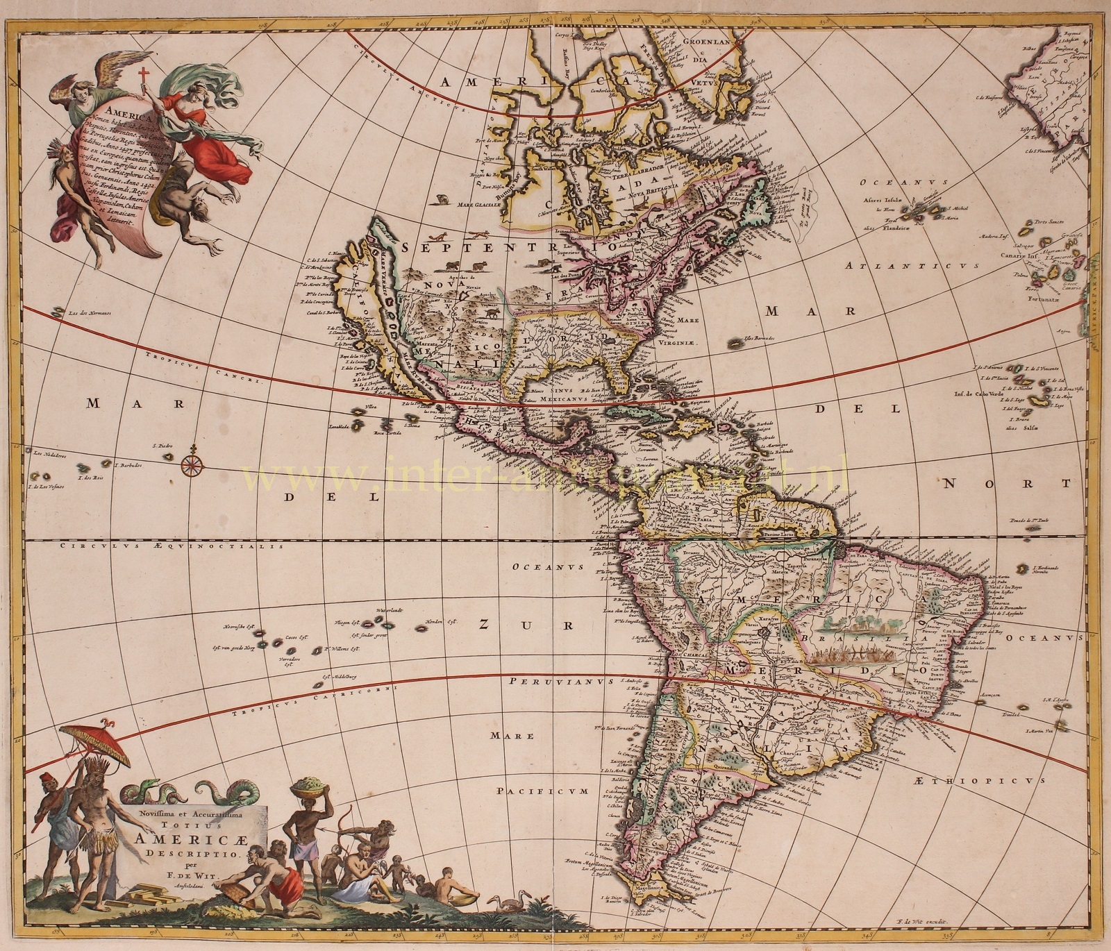


“Nova et Accuratissima Totius Americae“, copper engraving first published c. 1675, here in a 4th state (out of 9), published by Frederick de Wit c. 1680. With original hand colouring. Size : 49 x 58 cm.
De Wit’s Map of the Americas was the first Dutch map to include all five Great Lakes, an improvement on De Wit’s first map of the Americas (1660) and his wall map of 1672.
The map includes both North and South America, as well as much of the Pacific. It is based on De Wit’s earlier two maps of the continents, as well as draws on Guillaume Sanson’s map of North America, published in 1669. Skilful lettering conveys the impression that the two continents have been extensively explored. The northwestern part of North America is nevertheless uncertain. New Zealand in the Pacific is not shown.
California is depicted as an island. The west coast of Hudson Bay has been updated since De Wit’s earlier maps. The map predates La Salle‘s information on the interior of North America, but includes excellent detail in Canada and the East Coast of North America, noting the Dutch possessions, the Iroquois regions, N. Anglia, New Amsterdam, the Chesapeake, Plymouth, and many Indian place names. There are also many animals to fill the vast plains, including bears, foxes, and wolverines. Of most interest, though, are the five large lakes in the Midwest of the continent, “Lac Superieur” (Lake Superior), “Lac des Puans” (Lake Michigan), “Mare Dulce” (Lake Huron), “Lac Erie” (Lake Erie), and “L. de S. Louis” (Lake Ontario).
South America includes the Strait of Le Maire with a small “Staten Landt” and an open-ended island east of the “Straet de Brouwers”, a suggestion of the still-elusive southern continent. The many riverine networks are a striking feature of the continent, while the indigenous village and a battle being waged with bows and arrows in Brazil are also prominent.
The map includes two highly-decorative cartouches. The first, shown in the upper left corner, is held up by an indigenous American. An angel pulls the cartouche away as an evil, clawed figure (presumably the non-Christian belief) emerges from below. Above the clawed figure is a woman wearing a billowing dress, holding a cross to cast away the devilish figure. The Latin text translates as:
America has its name from Amerigo Vespucci, from Florence, who was sent out by the auspicious King Manuel of Portugal, from Cadiz, done in the year 1497, first out of Europe, how long indeed he remained. Although first Christopher Columbus, from Genoa, in the year 1492, on the order of Ferdinand, King of Castile, found the American islands Hispaniola, Cuba, and Jamaica.
The second cartouche is set in the bottom left corner of the map. There are serpents wrapped around the top of the text, and to either side are village scenes with people of all social strata of indigenous America. The man to the left of the text appears to be a noble; he is shaded by an umbrella, wears an elaborate head dress and cloth, and bars of gold lie at his feet.
Price: Euro 1.650,-