

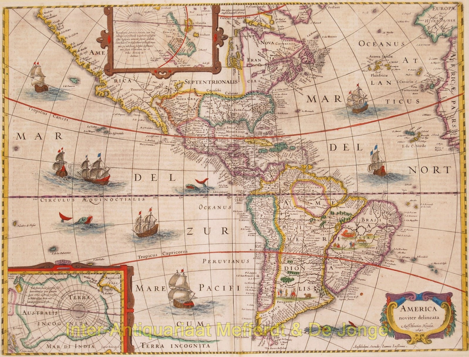
“America Noviter Delineata”
This important map was first published in 1618 by Jodocus Hondius. Cartographically, this map influenced a generation of cartographers and was the basis of understanding the Americas for the first half of the 17th century.
When first issued the map was surrounded by four panels, figures on the sides and Views on the top and bottom. The plate was trimmed, removing the panels by Henricus Hondius c.1630. The map had a long life appearing in atlases up to 1665,
This map is noted for its elegant engraving and pleasing layout, with fleets of ships and sea monsters, and two inset maps one showing the Arctic Circle and the other showing Greenland. The North Pole depicts Frobisher’s theory of the Northwest Passage and the South Pole shows the long-held notion of the mythical southern continent. North America retains the peninsular California and the East Coast is beginning to take shape, although it still lacks detail in the mid-Atlantic region. In the Southwest the famous seven cities of Cibola appear on the banks of a large lake. In South America, there is a large inland sea and two engraved scenes, one of which details a cannibalistic feast. Two stylized insets of the two polar regions are enclosed in strapwork cartouches. Size: 37,5 x 49,8 cm (plus margins).
The copperplate that produced this map was originally prepared by Jodocus Hondius Jr. in 1618. This issue, known in three examples, has decorative borders on all four sides. There is a 2nd state in c1629-30 with no decorative borders. A 3rd state was produced by Henricus Hondius in 1631. The map depicted here is the 4th state with the imprint of Janssonius and the addition of the date of 1641. There was a 5th state in 1652 with the date and the Hondius imprint removed. (Burden, p. 235-6).
This map has German text on the verso describing America. This map is from Johannes Janssonius‘ Atlas of 1646-57 with a signature on the verso of “Aaa”, based on van der Krogt (p. 715). An earlier version of this map was produced by Henricus Hondius in 1631. Through the collaboration between Hondius and Janssonius (they were brothers-in-law), Hondius’ map was replaced by Janssonius’ map in 1641. Henricus Hondius had died in 1638.
Reference: Burden map #192.
Size: 37,6 x 49,9 cm.
Price: Euro2.900,- (excl VAT/BTW)