


PROPAGANDA MAP SUPPORTING WORLD WAR I CENTRAL POWERS
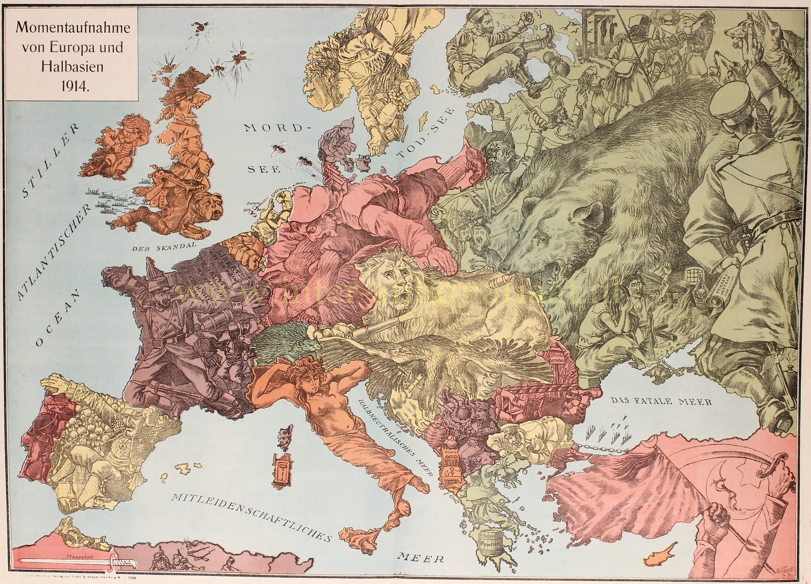
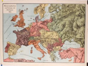
„Momentaufnahme von Europa und Halbasien 1914“, colour lithograph printed in 1914 in Hamburg by Grath & Kaspar. Size: 48,3 x 67,6 cm.
This rare and fascinating political propaganda map gives a German perspective at the beginning of World War I. The key countries involved in the war are represented by human or animal caricatures with various props that help illustrate the situation.
At the center of the conflict are Germany, Austria and Russia. Germany is represented by both an eagle, attempting to bite the hand of the French soldier, and a Deutscher Michel (an ordinary or average German), who clenches Belgium in his right hand while doing the splits to hold back the French soldiers with one foot as the other foot kicks a Russian soldier. Austria-Hungary is depicted as two ferocious animals: a lion holding a gun and shooting a bullet at the Russian bear, and a double-headed eagle pecking at the Balkans. The Russian bear, surrounded by Russian soldiers and scenes of civil strife, attacks the Austrian lion from behind. The French soldiers simply flee the German onslaught. A frightened-looking British soldier sits astride a bulldog while a venomous snake strikes from behind. Turkey flies a Turkish flag while holding a scimitar. Bulgaria is using a saw on Greece, which itself has a barrel of gunpowder on the Peloponnese. In Serbia, with a nasty hissing snake, there is a man using a knife on a crown. Albania is merely an empty chair with a question mark. Other countries are depicted as passive, including Italy as a Roman goddess statue, Sweden and Norway as a woman trying to protect her material resources, a Swiss sheep (or is it a rat), and a drunk Spaniard sitting in an orchard.
The Russian fleet is locked in the Black Sea (renamed “Das Fatale Mer”) by a chain across the Bosporus. The Mediterranean is renamed “Mitleidenschaftliches Mer” [compassionate sea]. The North Sea is called “Mord See” [murder sea] (rather than Nordsee) and the English Channel is called “Der Skandal” (rather than Der Kanal).
Although the human personification of continents and countries can be seen as early as the 14th century, human and animal metaphors on maps reached a new level in Europe between 1845 and 1945 with political cartoon maps. The rise of these satirical maps reflected the momentous political and cultural changes that occurred during the time. Political leaders were caricaturized and European nations were given symbolic identities that lent humor and accessibility to the geographical map. Based on popular stereotypes, these visual representations even found their way into the classroom to help bring geography and politics to life. Original serio-comic maps are very scarce due to their ephemeral nature.
Price: SOLD