


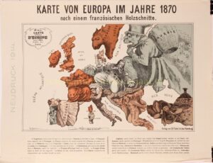
„Karte von Europa im Jahre 1870“. Lithograph published by Charles Fuchs in Hamburg in 1914. Size: 36,4 x 47,5 cm.
Nice example of the German edition of Paul Hadol‘s satirical political cartoon map (“carte drôlatique”) of Europe showing countries personified in caricature and alluding to the tensions that finally erupted as the Franco-Prussian War in July 1870.
In the center, a buffoonish Prussia interacts with its suspicious neighbours. England is depicted as an old woman holding its dog, Ireland, by a leash. Spain and Turkey are portrayed as unconcerned women on the fringes relaxing with a cigarette and a hookah respectively. Corsica and Sardinia become an impish figure mooning the viewer. A rifle with a bayonet near the bottom edge is sardonically labeled “Degrees of Longitude.” The various tensions and rivalries between the nations are described in the caption:
“England enraged forgets Ireland but still keeps it in her power. Spain & Portugal smoke away lazily. France tries to overthrow Prussia who advances one hand on Holland and one over Austria. Italy advises Bismarck to keep off. Corsica & Sardinia laugh on at all. Denmark hopes to recover Holstein. European Turkey awakens yawningly. Asian Turkey is inhaling the smoke of a waterpipe. Sweden crouching like a panther. Russia as Servant Rupert is trying for anything to fill his basket”.
Provenance: collection Martinus Cornelis Sigal (1888 – 1969), with collector’s stamp on verso.
Price: Euro 1.250,-