

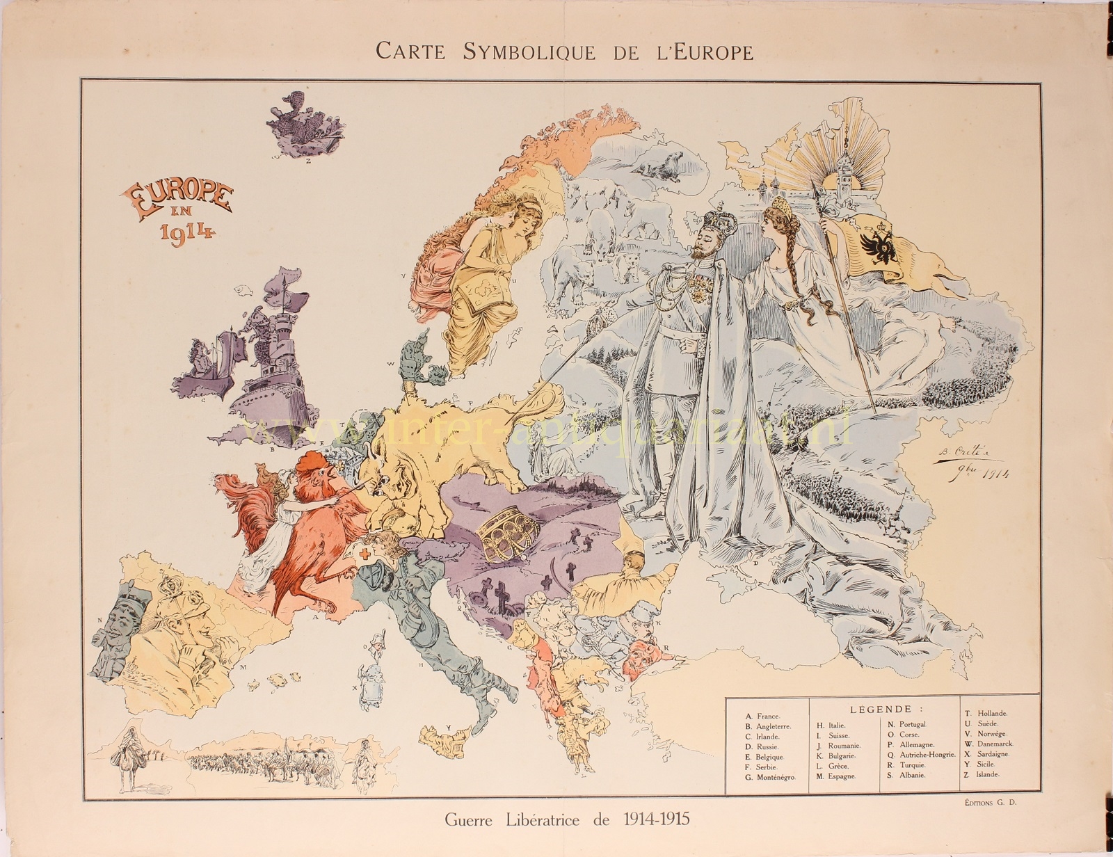
CARICATURE MAP OF EUROPE IN 1914
“Carte Symbolique de L’Europe. / Europe en 1914.” Lithograph printed in colour made by B. Crété in 1914/15. Size: (paper) 50 x 65 cm.
This rare political caricature map of Europe depicts the alliance situation and territorial issues towards the end of the first year World War I. The key countries involved in the war are represented by human or animal caricatures with various national symbols that help illustrate the situation.
The map was first issued in Poland where it was drawn by the Warsaw artist Vladislav Levinsky. Warsaw at the time being one of the largest cities in the Russian Empire, the ‘Russian Perspective’ is apparent. The image is dominated by the glorious and serene figure of Tsar Nicholas II who is poking Germany, illustrated as a raging bull focused on France, represented by Marianne, the symbol of the French Republic, riding a great cockerel. Behind the Tsar the endless armies of Russia mobilize – a reference to Tsar Nicholas II’s July 1914 decision to mobilize the Russian army, this ‘prodding’ Germany to declare war, which it swiftly did. Habsburg Austria is depicted a dead field with grave markers and an upside down fallen crown, foreshadowing the end of the Austro-Hungarian Empire. England, at sea, hides behind her Navy. Finland, still being part of the Russian Empire, is full of wild animals. Norway and Sweden are stereotypically beautiful maidens looking over an atlas. Italy is a peaceful mandolin player lulling Sicily to sleep. Spain and Portugal are neutral, but Alfonso XIII, a known auto enthusiast is shown behind the wheel.
This map appeared in several editions in Poland and Paris through 1915, with only minor changes. It is unclear which hold primacy or if they were published simultaneously.
Although the human personification of continents and countries can be seen as early as the 14th century, human and animal metaphors on maps reached a new level in Europe between 1845 and 1945 with political cartoon maps. The rise of these satirical maps reflected the momentous political and cultural changes that occurred during the time. Political leaders were caricaturized and European nations were given symbolic identities that lent humor and accessibility to the geographical map. Based on popular stereotypes, these visual representations even found their way into the classroom to help bring geography and politics to life. Original serio-comic maps are very scarce due to their ephemeral nature.
Provenance: collection Martinus Cornelis Sigal (1888 – 1969), collector’s stamp on verso.
Price: 1.650,-