

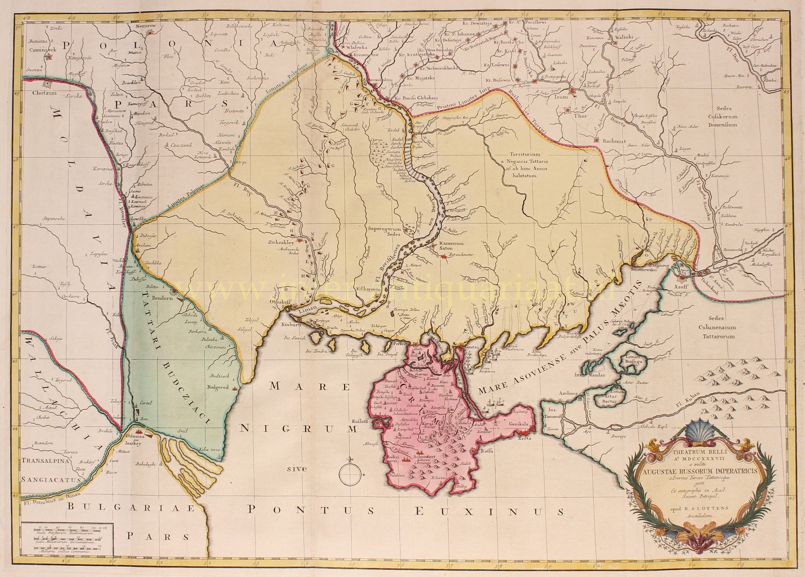

SOUTHERN UKRAINE AND CRIMEA DURING THE RUSSO-TURKISH WAR 1736-1737
“Theatrum Belli Ao. MDCCXXXVII a milite Augustae Russorum Imperatricis adversus Turcas Tattarosque”. Copper engraving on two joined sheets, published by Reinier & Josua Ottens in Amsterdam in 1737. With original hand colouring and later additions. Size: 66,8 x 47,5 cm.
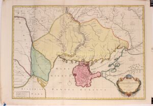
Superb map depicting the theatre of the Russo-Turkish War in present-day Ukraine, showing the Russian operation of 1736-1737.
The war began in July 1735, when the Russians invaded Ottoman-controlled territories along the Black Sea coast. The main cause of the war was a territorial dispute over the border between the two empires in the Caucasus region. Russia sought to expand its influence in the area and gain control over the Black Sea trade routes, while the Ottomans sought to maintain their control over the region.
The Russian forces, led by field marshal Burkhard Christoph von Münnich (1683-1767), achieved some initial success and captured several Ottoman strongholds in the Black Sea region. However, the Ottoman forces, led by Grand Vizier Topal Osman Pasha, launched a counter-offensive and managed to recapture some of the lost territories.
The war continued for two years, with both sides suffering heavy losses. However, the Russians eventually gained the upper hand and in 1739, the Treaty of Niš was signed, which ended the conflict. The treaty recognized Russia’s control over the territories it had captured, including Azov and the Black Sea coast, and allowed the Russian Empire to establish a permanent presence in the region.
The war had significant implications for the balance of power in Europe and the Middle East, as it marked the beginning of Russia’s expansionist policies in the region and the decline of the Ottoman Empire’s power and influence.
The map provides excellent detail of the fortifications including the Ukrainian line – a system of defenses from the Dnipro to the Donetz rivers. It was compiled from manuscripts by the military cartographer Carl von Frauendorff. The march of the Russian army under the command of field marshal Münnich is shown from the crossing of the Dnieper at Vlasovka (“Wlassowka”) to Ochakiv (“Otzakoff”), which his army took by storm on 2 July 1737. The rectangles which are used to represent the army are diagonally shaded. Münnich’s marches to and from the Crimea in 1736 are shown, together with the siege of Kinburn by Russian troops, begun on 23 July, and other operational movements of the armies during 1736-1737.
Price: Euro 1.450,-