

Amsterdam – Andries de Leth, 1726-1731
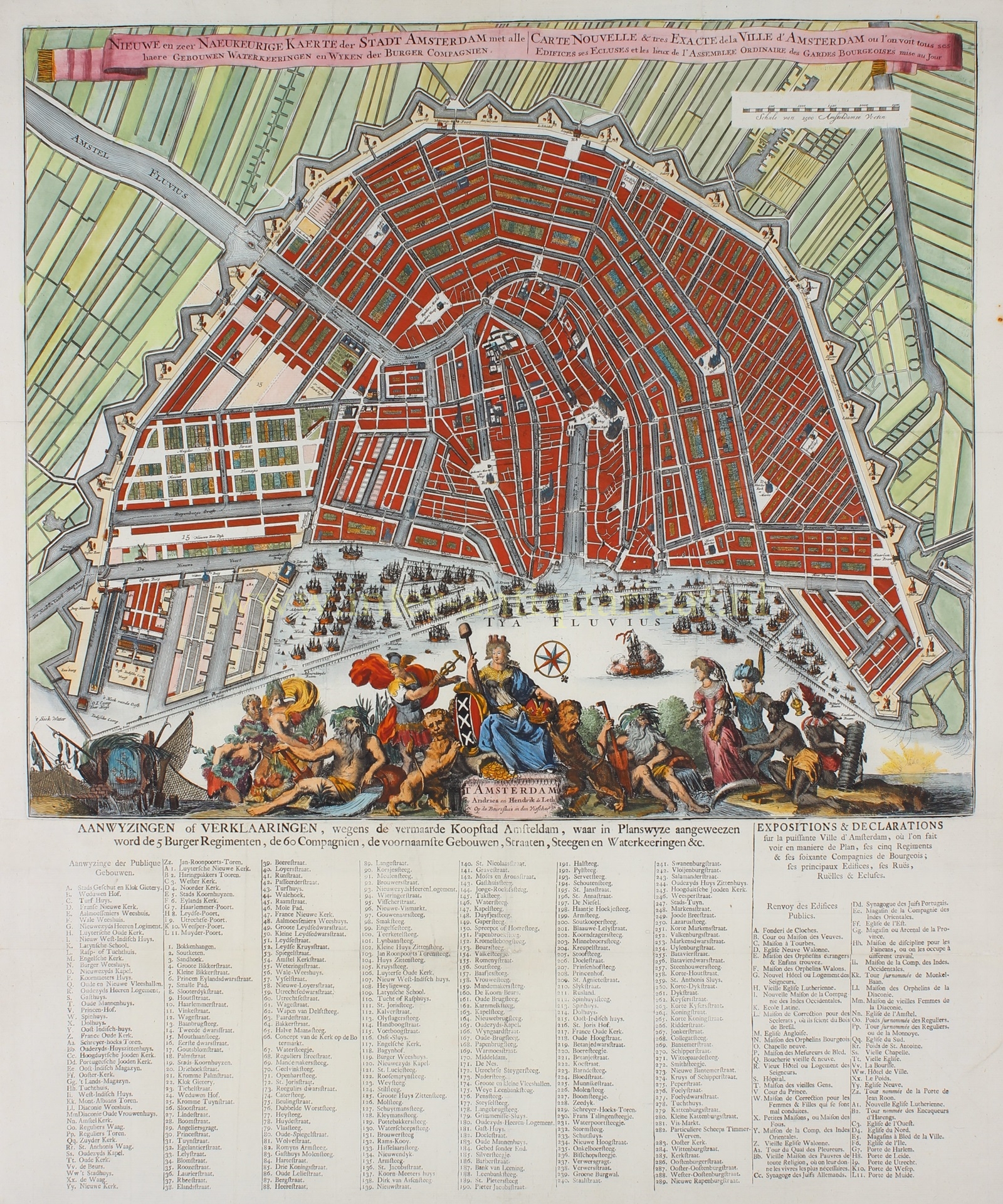

FIRST WATER MANAGEMENT MAP OF AMSTERDAM
“Nieuwe en zeer Naeukeurige Kaerte der Stadt Amsterdam met alle haere Gebouwen Waterkeeringen en Wyken der Burger Compagnien.” [new and very accurate map of the city of Amsterdam with all Its buildings, water barriers, and civic guard districts] Copper engraving made by Hendrick Focken in 1682, here is a revised edition of 1726-1731 by Andries de Leth. Coloured by a later hand. Size (map): 44 x 53 cm (incl. legend 64,5 x 53 cm).
At some point, Andries Karstensz. de Leth got his hands on the copperplate of the map by Hendrik Focken. Andries (1662-1731), the father of Hendrik de Leth (1703-1766), took over the shop in 1726 from Elizabeth Verseyl, the widow of publisher Nicolaes Visscher, who had passed away that year. That is why Visscher’s shop name is mentioned in the title cartouche. The acquisition of the shop and the year of his death determine the dating of the second edition.
In this edition, the map image was completely reworked from the plate. Without a doubt, this was done by Hendrik de Leth, Andries’ son. He was a skilled engraver. He made a new title, a scale bar, and an entirely new map image, including the area around the city.
The decoration at the bottom remained largely unchanged in this edition. Hendrik Focken had copied the exuberant scene from a map from 1674, engraved by Romeyn de Hooghe. At the center of the decoration sits the city’s maiden, holding the city’s coat of arms and the imperial crown, accompanied by two lions. To her left is Mercury, the god of commerce, and the river god of the Amstel, who is receiving fruits of the land from Bacchus, Pan, and Ceres. On the far left is the city’s seal, surrounded by nets and fish hanging to dry. On the right, we see the river god of the IJ and the personification of the four continents. Without a doubt, this scene intends to signify the position of the city of Amsterdam as a commercial city and as an important link between the hinterland and the wider world.
Below the map image in this edition by De Leth, there is a separately printed legend titled “Directions or explanations concerning the renowned commercial city of Amsterdam, in which the 5 civic regiments, the 60 companies, the principal buildings, streets, alleys, and water barriers, etc., are shown in a planned manner.” The names of the public buildings were also printed in French to the right.
Andries and Hendrik de Leth made the map thematic by adding hydraulic engineering information. We can see the flow directions of the water that was used to refresh the canals. The earlier system, which utilized the natural fall of the Amstel river for water replenishment, had been abandoned, and now only the tides and some watermills were used. This system had been in place since the construction of the Amstel locks between 1672 and 1674. However, Andries and Hendrik de Leth were the first to visualize it on a printed map. The number of lines gives an indication of the water quantities: in the Amstel, there are four dotted lines, in the Rokin, two, and in places like the Singel and the Kloveniersburgwal, only one. All the streams eventually flow back into the IJ. The image is further clearified by small flow arrows. The Amstel locks would only remain open on both sides when a dangerously high water level in the upper river posed a flood risk.
Literature: “Kaarten van Amsterdam 1538-1865”, Marc Hameleers, no. 84/2.
Price: SOLD