

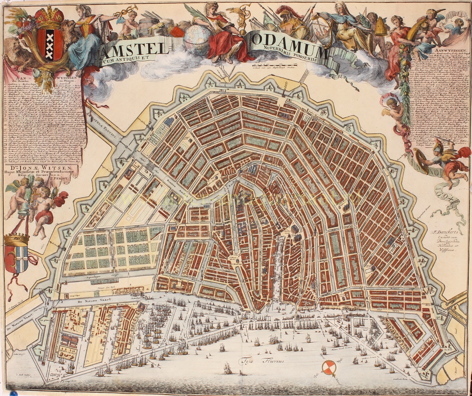
AMSTERDAM DECORATED BY ROMEYN DE HOOGHE
“Amstelodamum cum Antiquis et Nuperrimis Pomoeriis” [Amsterdam with its old and recent city boundaries], etching with engraving made by Romeijn de Hooghe, first published in 1694 by Pieter Persoy, here in a second edition published by Theodorus Danckerts between 1701-1704. Coloured by a later hand. Size: 47 x 56.5 cm.
Publisher Pieter Persoy lived in Amsterdam on the corner of Dam and Beursstraat. In 1694, Persoy dedicated the map to the then eighteen-year-old Jonas Witsen (1676-1715), a nephew of the well-known Amsterdam mayor Nicolaes Witsen. Nicolaes elevated Jonas by appointing him as city secretary at the age of seventeen. On the map, below the legend on the left, Jonas Witsen is mentioned by Persoy as the secretary of the illustrious and influential city. The three cherubs below carry a pillar with a ribbon featuring the coat of arms of the Witsen family. The putti are allegorical figures. The left putto represents the virtue of Fortitudo (strength), the middle with a blindfold represents Justitia (justice). The right putto carries a snake and a mirror representing Prudentia (prudence/wisdom).
The style of the decorations above the depiction reveals the hand of Dutch master engraver Romeyn de Hooghe. He designed four allegorical female figures as well as symbols that were important to Amsterdam: from left to right, we see the lion as a symbol of strength, the cornucopia, the city coat of arms, the staff of Mercury as a symbol of trade, a cherub with a barrel and various bags symbolizing the city as a center of trade and transshipment, a globe on which the city maiden rests her arm as a sign of Amsterdam as the most important city, the goddess Pheme heralding fame, weapons and armor as symbols of military strength, the city seal with a cog ship, a cherub with a beehive as a symbol of industriousness, and once again, a cornucopia.
In the map, the area bounded by Binnen Amstel, Keizersgracht, Achtergracht, and Muidergracht is still sparsely built, although the map was published years after the city’s so-called Fourth Expansion had begun. The fact that only few houses were built was due to the decline of the Amsterdam’s economic situation, which would last for decades.
No copies of the first edition of this map are known to have survived. However, a third edition was published between 1704-1726 by Gerard van Keulen, who published the map unchanged, only replacing Danckerts’ name with his own.
Price: SOLD