

Manila Bay – François Valentijn, 1724-1726
EARLIEST OBTAINABLE CHART TO SHOW MANILA BAY IN DETAIL
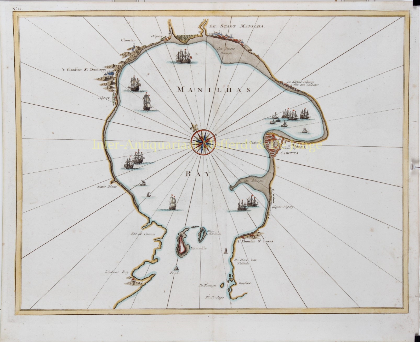
“Manilhas Bay”, copper engraving from François Valentijn’s “Oud en Nieuw Oost-Indien”, made by Jan van Braam and published in Dordrecht by Gerard onder de Linden in 1724-1726. Coloured by a later hand. Size: 30 x 38,5 cm.
The chart is oriented northeast, so as to give the bay a vertical orientation. It shows Manila, Cavite (“Cabitta”), the monasteries of St. Lucas and St. Domingo, and a further unnamed monastery around the edges of the circular bay. Manila and Cavite are shown with many buildings in relief.
Stippling reveals the “droogtes”, or dry areas close to the shore. A compass rose sits dramatically in the middle of the bay. Numerous ships are sailing or idling on the water, underlining the importance of Manila as a port.
Manila was one of the most important ports in all of the Pacific. It enjoyed this status for centuries before Europeans came to Southeast and Maritime Asia. The Spanish arrived in the islands, first in 1521 and more permanently in 1565. They took over Manila in 1571, naming it the capital city of their colony, which technically fell under the jurisdiction of the territory of New Spain.
It was associated with New Spain and Spanish America because it was the western terminus of the circular Manila-Acapulco trading route. From 1565 to 1815, galleons would leave Acapulco filled with silver. In Manila, this silver would be piped into Asian, particularly Chinese, markets. The galleons were then filled with Asian trade goods and returned to Acapulco. These galleons were the largest wooden ships ever built, and many were made in Cavite, shown on this chart.
In 1646 a series of battles took place where the Dutch made attempts to invade Manila. The Spanish forces, which included many native Kapampángan volunteers, consisted of two, and later, three Manila galleons, a galley and four brigantines. The Dutch came with a fleet of nineteen warships, divided into three separate squadrons. Heavy damage was inflicted upon the Dutch squadrons by the Spanish-Kapampángan forces, forcing the Dutch to abandon their invasion of the Philippines.
François Valentijn was a prominent historian of the Dutch East India Company (V.O.C.) who is best known for “Oud en Nieuw Oost Indiën”, his vast illustrated account of the Dutch trading empire in Asia. He travelled to the East Indies twice and served as Calvinist minister to Ambon between 1686 and 1694. In preparing this monumental work, he was given privileged access to the previously secret archives of the V.O.C., containing transcripts and copies of important earlier Dutch voyages.
While Valentijn’s maps and diagrams were prized possessions, his scholarship, judging by 21st century standards was unscrupulous. Valentijn’s use of the products of other scientists’ and writers’ intellectual labour and his passing it off as his own, reveals a penchant for self-aggrandisement.
Price: SOLD