


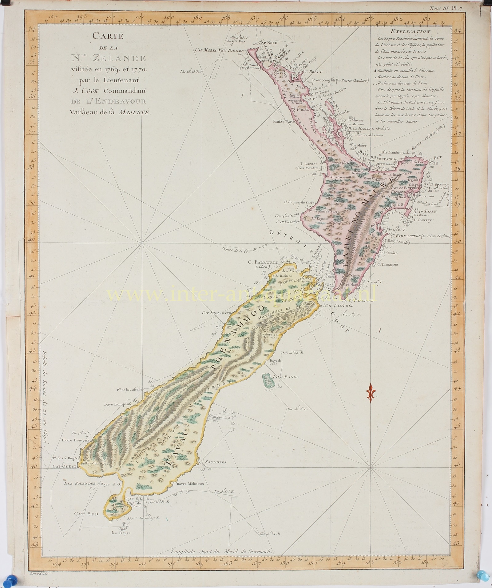
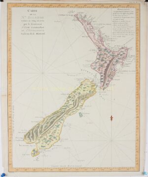
FRENCH EDITION OF THE FIRST PRINTED CHART OF THE WHOLE OF NEW ZEALAND
“Carte de la N.le Zelande“. Copper engraving made by Robert Bénard after the work of James Cook, published in 1774 as part of John Hawkesworth’s book “Relation des voyages entrepris par order de sa Majestie Britannique…”. Coloured by a later hand. Size: 38 x 48 cm.
This is the first French edition of the most important single map in New Zealand’s history and the first complete map of the two islands’ coastlines. It confirmed that New Zealand was not part of a mysterious southern continent and records some of the earliest interactions between Europeans and Maoris.
Captain James Cook (1728-1779) undertook the surveys used to create this work during his first voyage in 1769 and 1770, making him and his crew the first Europeans to visit the islands since they were discovered by Dutch explorer Abel Tasman in the early 1640s. Cook’s map is also the first to detail the coastline of both islands and labels their points, bays, and capes. The mountainous interior topography as it was perceived from Cook’s ship and the shore is also illustrated. The course of Cook’s ship, the HMS Endeavor, is traced as well, with dates, depth soundings, and compass headings noted. Many of the place names Cook bestowed upon the islands remain to this day, including Mount Egmont, the Bay of Plenty, Hawke’s Bay, the Bay of Islands, and the Bay of Kidnappers.
Of the chart itself, Cook wrote in his journals:
“The Chart which I have drawn will best point out the figure and extent of these Islands…beginning at Cape Palliser and proceed round Aehei no mouwe (North Island) by the East Cape etc. The coast between these two capes I believe to be laid down pretty accurate both in its figure and the course and distance from point to point. The opportunities I had and the methods I made use on to obtain these requesites were such as could hardly admit of an error…some few places however must be excepted and these are very doubtful…”
Cook’s achievement in mapping New Zealand established the value of the islands as potential colony and point of greater interest for the British.
The British Hydrographic Office began reprinting this chart for their vessels beginning in 1816 and it was consulted by mariners well into the twentieth century, lending it incredible longevity. Because of its accuracy and the complexity of the task, it is considered to be one of Cook’s best maps.
Price: Euro 1.650,-