

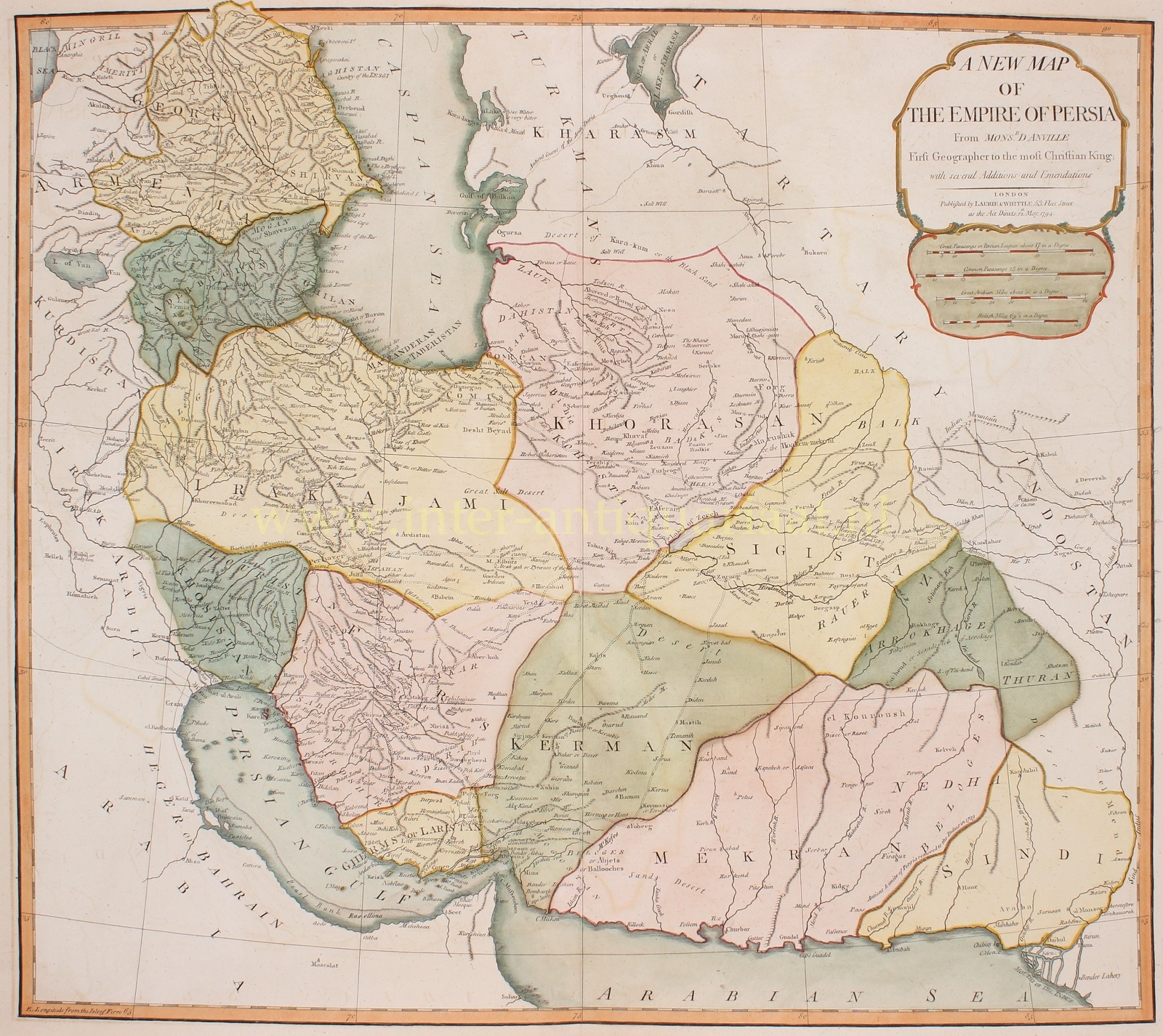
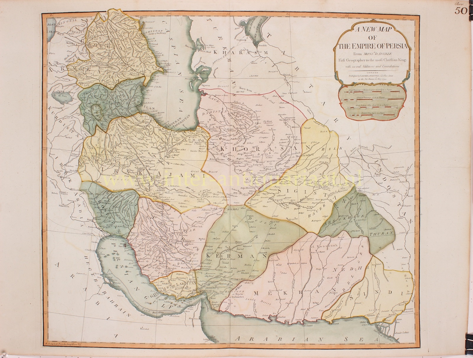
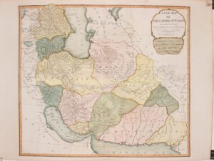
“A New map of the Empire of Persia” copper engraving after the work of Jean Baptiste D’Anville, published by Laurie & Whittle in London in 1794. Original hand colouring wih later additions. Size: approx. 51 x 62 cm.
The map covers the Persian Empire from the Black Sea in the west and the Persian Gulf in the south until Kashmir and Punjab in India, including the modern day nations of Iran, Iraq, Georgia, Armenia, Azerbaijan, Turkmenistan, Afghanistan, Pakistan and parts of India. The map identifies numerous towns, villages, deserts, mountain ranges, river systems and a host of other topographical features.
During this time, Persia was passing through the waning years of the short lived Zand Dynasty, which ruled from the capital city of Isfahan – identified here as Ispahan. The death of Karim Khan, the founder of the Zand Dynasty, in 1779 led to civil war. In a few short years, in 1794, Aga Muhammad Khan overthrew Lotf Ali Khan, the last Shah of the Zand Dynasty, and relocated the capital to the new city of Tehran. The subsequent era, the Qajar Dynasty, witnessed numerous military conflicts with the rising powers of Imperial Russia and the loss of much of Persia’s territory.
The map marks a number of explorers’ tracks, notably “Mr. Forster’s Route in 1783 and 1782 From the Indus to the Caspian Sea”. George Forster was a civil servant attached to the Madras establishment of the East India Company. In 1782, he travelled overland from Calcutta to Kabul, then through northern Persia to the Caspian Sea and thence across the sea into Russia. The account of his journey was published in Calcutta in 1790, although only the first volume appeared before his death in 1792, which is only comparatively shortly before this map appeared.
Jean Baptiste Bourguignon d’Anville (1697 – 1782) was perhaps the most important and prolific cartographer of the 18th century. At the age of twenty-two D’Anville, sponsored by the Duke of Orleans, was appointed Geographer to the King of France. As both a cartographer and a geographer, he instituted a reform in the general practice of cartography. Unlike most period cartographers, D’Anville did not rely exclusively on earlier maps to inform his work, rather he based his maps on intense study and research. His maps were thus the most accurate and comprehensive of his period – truly the first modern maps. In 1754, when D’Anville turned 57 and had reached the height of his career, he was elected to the Academie des Inscriptions. Later, at the age of 76, following the death of Philippe Buache, D’Anville was appointed to both of the coveted positions Buache held: Premier Geographe du Roi, and Adjoint-Geographer of the Academie des Sciences. During his long career D’Anville published some 211 maps as well as 78 treatises on geography. D’Anville’s vast reference library, consisting of over 9000 volumes, was acquired by the French government in 1779 and became the basis of the Depot Geographique – though D’Anville retained physical possession until his death in 1782. Remarkably, almost all of D’Anville’s maps were produced by his own hand. His published maps, most of which were engraved by Guillaume de la Haye, are known to be near exact reproductions of D’Anville’ manuscripts.
Price: SOLD