

SURINAME COASTAL CHART
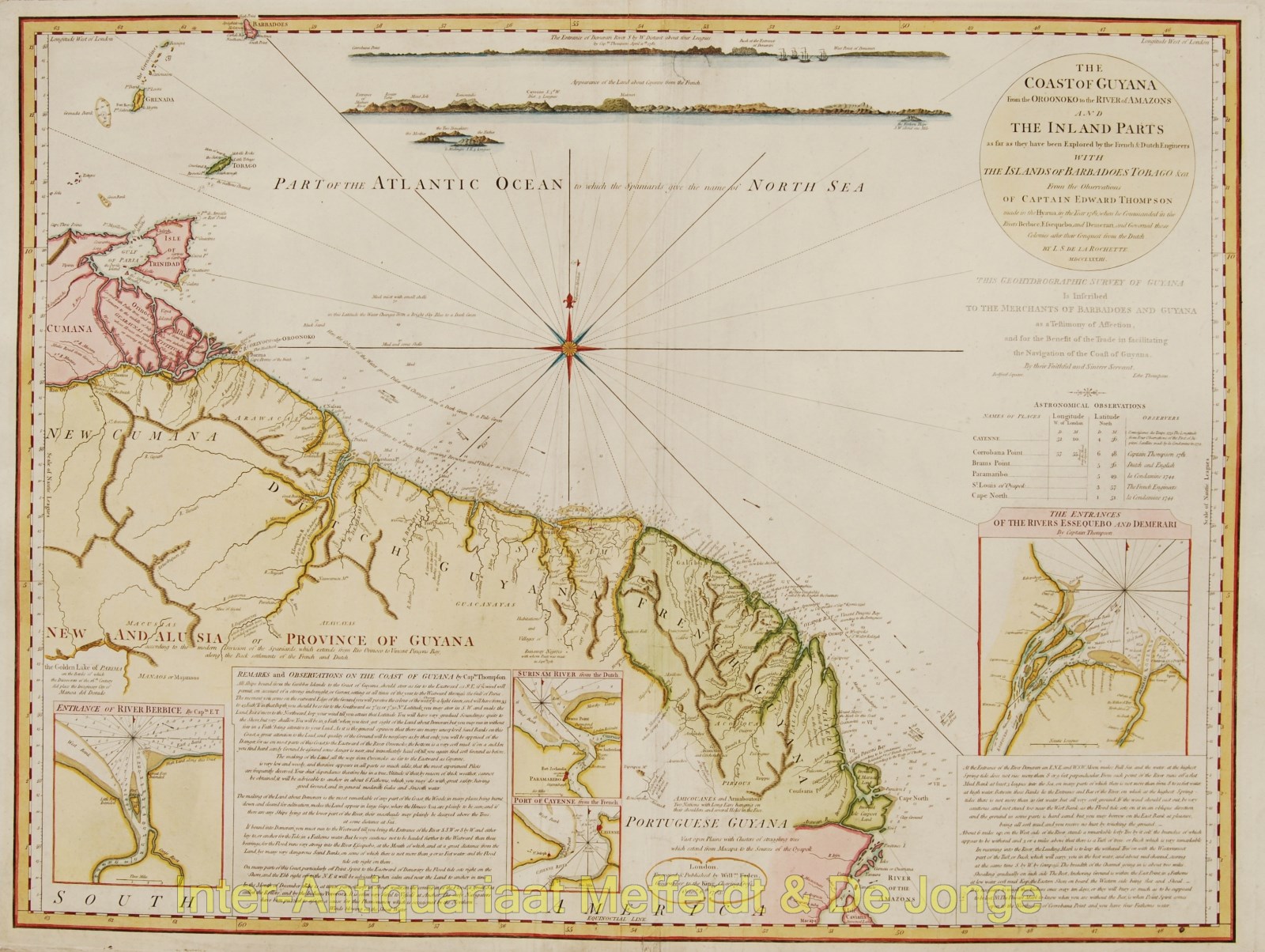
“The Coast of Guyana from the Oroonoko to the River of Amazons and the Inland Parts as far as they have been Explored by the French & Dutch Engineers with the Islands of Barbadoes Tobago. From the Observations of Captain Thompson made in the [HMS] Hyaena in the year 1781 when he Commanded in the Rivers Berbice, Essequebo, and Demerari, and Governed those Colonies after their Conquest from the Dutch.“ Copper engraving made by cartographer Louis Stanislas De La Rochette, published in 1783 by William Faden. Coloured by a later hand. Size 51 x 68 cm.
Interesting overview map of the coast of Guyana with four inset maps of the entrances to the Berbice, Suriname, Cayenne and Essequibo rivers. With intriguing descriptions on how to navigate best: “All ships bound from the Caribbee Islands to the Coast of Guyana, should steer as far to the Eastward as S.E. if ye wind will permit, on account of strong indraught, or Current, setting at all times of the year, to the Westward through the Gulf of Paria. The moment you come to the outward Edge of the Ground you will perceive the colour of the water change to a light Green, and will have from 35 to 45 Fathoms.”
“If bound into Demerari you must run to the Westward till you bring the Entrance of the River S.S.W. or S. by W. and either lay to, or anchor for Tide, in 4 Fathoms water: But be very cautious not to be hauled further to the Westward than these bearings, for the flood runs very strong into the River Essequebo, at the Mouth of which, and at a great distance from the Land, lye many very dangerous Sand Banks, on some of which there is not more than 9 or 10 feet water; and the Flood tide sets right on them.”
Captain Thompson was sent to Guyana to take control of the colonies of Demerara and Essequibo, after they had been taken from the Dutch. After preparing as much of the defences as he could with limited resources he sailed back to England to protect a convoy of English merchants. However, while he was gone a French squadron captured the colonies, so he was subjected to a courtmartial for leaving his post without orders. The court, held in April 1782, found him blameless and acquitted him. This map is dedicated to the “merchants of Barbadoes and Guyana” for whom he risked so much. Throughout his career in the Navy he also wrote plays, songs and poetry: his writing has appeared in anthologies about slavery and naval sea-shanties.
Price: SOLD