

The Hague – J. Smulders & Co., ca. 1881


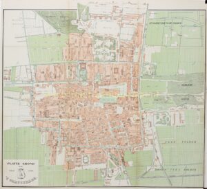
“Platte Grond van ’s Gravenhage”, [plan of The Hague], colour lithograph published by J. Smulders & Co., ca. 1881. Size: 44 x 48 cm.
This fine and detailed city plan shows The Hague during a period of profound urban transformation. Around 1880 the city was evolving from a leafy administrative center into a modern residence city of metropolitan character. The map clearly shows how the historic core — with the Binnenhof, the Hofvijver, and the broad avenues of the Willemspark — was still surrounded by open meadows and polders, while the first expansions were beginning to take shape.
On the western side, the Zeeheldenkwartier is shown under development, with its characteristic rectangular street pattern and modern housing blocks for the rising middle class. To the east of the center lies the Stationsbuurt, which had developed into a busy commercial and residential district since the arrival of the Hollands Spoor railway station in 1843. The green areas of the Haagsche Bosch, Malieveld, and Scheveningse Bosjes mark the natural boundaries of the city, while to the south the Laakhaven and Trekvliet indicate the beginnings of industrial The Hague.
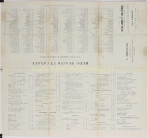
Of particular interest is the French-language index printed on the verso, listing “streets, public buildings and various useful pieces of information,” including barracks, museums (such as a “Cabinet de Curiosités et de chinoiseries” near the Mauritshuis, and a “Cabinet de Tableaux du feu le Baron Steengracht” on the Lange Vijverberg).
The plan is characteristic of the maps published by J. Smulders & Co., who around 1880 issued a series of colour urban plans. It provides a clear picture of The Hague’s urban structure on the eve of its great expansion toward Bezuidenhout, Duinoord, and the Statenkwartier — developments that would permanently transform the city by the end of the nineteenth century.
Price: SOLD