

Engeland – Nicolaas Visscher, ca. 1690
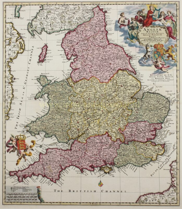
THE KINGDOM OF ENGLAND IN THE 17TH CENTURY “Angliae Regnum tam in Septem Antiqua Anglo-Saxonum Regna quam in Omnes Hodiernas…
Lees verder€550
THE KINGDOM OF ENGLAND IN THE 17TH CENTURY
“Angliae Regnum tam in Septem Antiqua Anglo-Saxonum Regna quam in Omnes Hodiernas Regiones Accuratissime Distinctum” [The Kingdom of England very accurately depicted both into the seven ancient Anglo-Saxon Kingdoms and into all present regions.] Copper engraving published by Nicolaes Visscher II around 1690. With original hand colouring. Size: 49 x 56.1 cm.
Nicolas Visscher II’s beautiful map of England is a fascinating blend between a historical and modern map.
The kingdom of England emerged from the gradual unification of the early medieval Anglo-Saxon kingdoms known as the Heptarchy: East Anglia, Mercia, Northumbria, Kent, Essex, Sussex, and Wessex. The map shows these seven kingdoms, but also depicts the contemporary counties.
After a series of conflicts between the Dutch and the English, it was the Glorious Revolution (1686-1688) that made Dutch stadholder William of Orange king of England. Relationships between both countries at the end of the 17th century were therefore very good. Dutch publisher Nicolaes Visscher praised the new English king with this map. It would take almost a century before a next Anglo-Dutch war.
The map is dense with the names of towns and cities, with post roads delineated throughout.
At top right there is an elaborate title cartouche with several allegorical figures flocked around Saint Cecilia and her lyre; below is the royal arms and a dedication to William III.
The cartouche is signed by draftsman Philip Tideman and engraver Gilliam van der Gouwen. Another cartouche at bottom left includes a key and three distance scales, and two putti hoist the royal arms of England at left.
Price: Euro 550,- (incl. frame)