
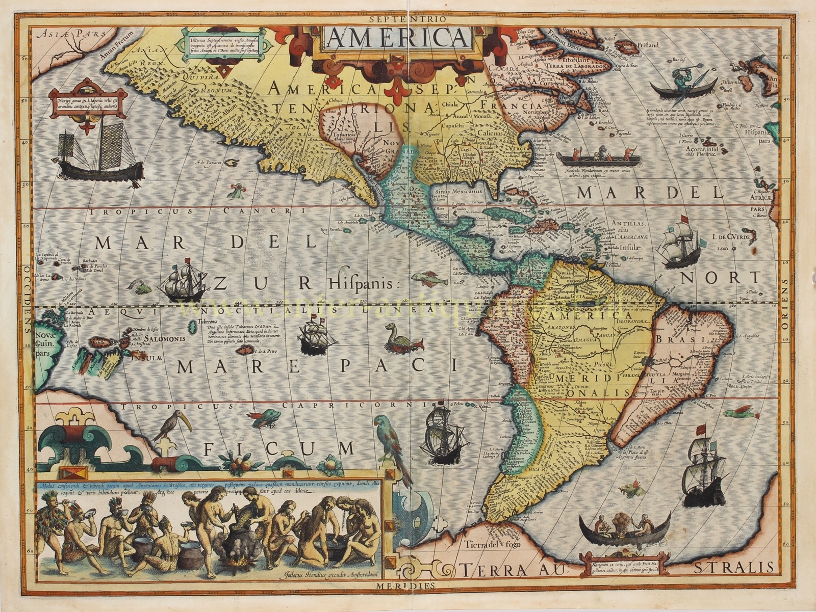
Amerika – Jodocus Hondius, 1606
HONDIUS’ HIGHLY SOUGHT AFTER MAP OF THE AMERICAS “America” copper engraving made by Jodocus Hondius the Elder for his first…
Lees verder€4.950
HONDIUS’ HIGHLY SOUGHT AFTER MAP OF THE AMERICAS
“America” copper engraving made by Jodocus Hondius the Elder for his first edition of Gerard Mercator’s atlas published in Amsterdam in 1606. With handsome original hand-colouring. Size: 37.5 x 50 cm.
The map shows the North and South American continents surrounded by fantastic beasts, ships, and decorative elements that make this a distinct highlight of early-seventeenth century mapmaking. It was made especially for Hondius’ first edition of the Mercator atlas, the plates of which he acquired only two years before this map was made, in 1604.
The two continents are surrounded by a veritable menagerie of sea monsters; some resemble flying fish, others strange alien creatures (or is it a hammerhead shark off the coast of California?) Also at sea are various water craft from cultures ringing the waters shown on the map. To the west is a Japanese square-rigged vessel “with sails woven from reeds and wooden anchors.” Further south are three European vessels in full sail. Off the coast of Terra Australis there is a “boat made of hides, which the inhabitants of the Strait of Magellan use, in which they continuously build fires.”, near another European ship. Further north, beyond yet another tall ship, a second canoe also carries a fire and a note explains that the canoes are also hollowed out by fire. Even further north is a kayak of which it says “the Greenlanders use a certain type of boat made of hides, in which there is space for only one person, and only a paddle is needed. With their right hand, they hold the tool and skillfully hurl spears at birds.”
There are also two cartouches on the map. At the top center is the title, “America,” in a strapwork cartouche common to the period. The more impressive cartouche is in the bottom left corner. This strap-work frame, with two birds perched on top, separates the rest of the map from a scene depicting Brazilian natives brewing cauim, an alcoholic beverage made from manioc root (cassava). The manioc is boiled, then women – here it says virgins – chew the root because enzymes in the saliva will help the mixture to convert from starch to fermentable sugars. The mixture is then boiled again and left to ferment in pots. The pictures should be read from right to left, as women made the drink and men consumed it. “This drink is considered a delicacy among them.”
There is a wealth of cartographic detail included on this map, which was supposed to be the definitive map of the continent when it was first published. The map shows a more accurate west coast of South America than its Mercator predecessor. Hondius considerably narrows the continent as well. Several large lakes feature in the interior. The largest is a long, thin horizontal lake in Guiana, a reference to legendary Lake Parime, which is associated with the voyages of Sir Walter Raleigh and was sought by many Europeans. Hondius knew Raleigh when he lived in London in the late sixteenth century and still benefited from knowledge he gained there in later maps.
To the south, the Strait of Magellan separates South America from a huge southern continent which extends east as well as west, snaking behind the cartouche. This was a common conjecture at the time, as the 1615-1617 circumnavigation by Willem Schouten and Jacob Le Maire had not yet shown Tierra del Fuego to be an island.
The Pacific Ocean is featured prominently, with many islands clustered in the west. These include the Solomon Islands, visited but not accurately charted by the Mendaña expedition in the sixteenth century, and part of New Guinea. In the central Pacific are two indistinctly-shaped islands called Tiburones (Spanish for sharks) and St. Peters. A note explains: “These two Islands Tuberones and St. Peters were by Magellan called unfortunate because in them he found neither man nor food for the life of man, fishing however is quite convenient.”
Unlike its counterpart, North America retains its wide projection, especially to the north. The east coast includes a bizarre projection of Virginia – it is shown as a blockish peninsula stretching far east into the Atlantic Ocean. To the northwest, the coastline extends nearly due west, split from Asia only by the much talked about Strait of Anian, a Northwest Passage to China. It appeared on maps until the mid-eighteenth century.
Another significant cartographic construct of the early modern period is also shown on this map. Hondius includes “Quivira Regnum” near “Anian Regn.” Quivira refers to the Seven Cities of Gold sought by the Spanish explorer Francisco Vasquez de Coronado in 1541. In 1539, Coronado wandered over what today is Arizona and New Mexico, eventually heading to what is now Kansas to find the supposedly rich city of Quivira. Although he never found the cities or the gold, the name stuck on maps of southwest North America, wandering from east to west. Here it is used to describe the entire southwest of the North America.
The map debuted in the 1606 Latin edition of the Hondius-Mercator atlas. It appeared in the atlases until 1630.
Literature: Philip D. Burden (1996) “The Mapping of North America”, vol. I, map 150.
Price: Euro 4.950,-