

Meer van Genève – Jean-Louis-Daudet naar Antoine Chopy, 1730
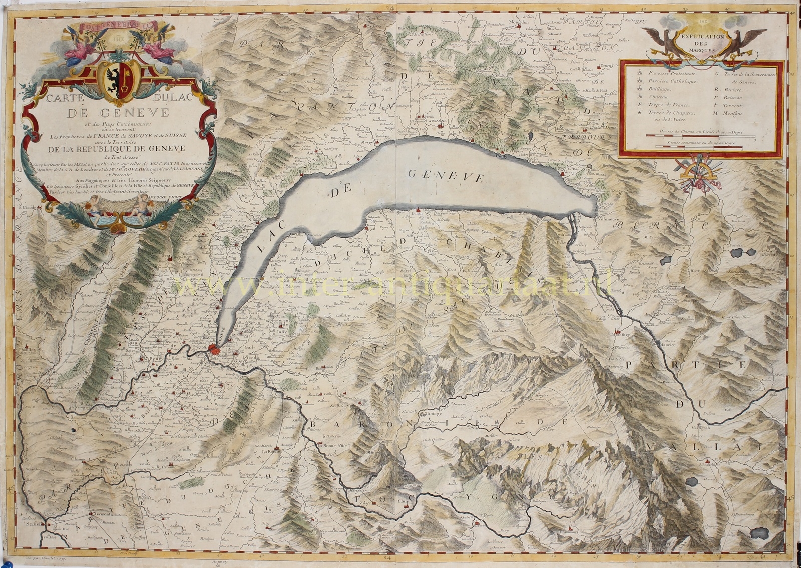
LOVELY LAKE GENEVA “Carte du Lac de Genève et des pays circonvoisins…” Copper engraving made in 1730 by Jean-Louis Daudet…
Lees verder€1.450
LOVELY LAKE GENEVA
“Carte du Lac de Genève et des pays circonvoisins…” Copper engraving made in 1730 by Jean-Louis Daudet after a drawing by Antoine Chopy. Coloured by a later hand. Size: 57,5 x 81,3 cm.
This large map appeared in the book “Histoire de Genève, rectifiée et augmentée par d’amples notes,” originally written by Jacob Spon in the 1680s and then updated by a team of scholars to be republished in 1730. Chopy credits Jean Christophe Fatio (a Genevan philosopher and intellectual) and Isaac Gamaliel Roverea (a Swiss cartographer and engineer) as influences on his map.
Around the year 1700, the area surrounding Lake Geneva was characterized by a complex political and social landscape. The shores of Lake Geneva were divided between several political entities. The Republic of Geneva was an independent city-state, governed by an increasingly aristocratic system. The northern and eastern shores were largely controlled by the Canton of Bern, part of the Swiss Confederation. The southern shore was under the control of the Duchy of Savoy.
Geneva itself was experiencing a period of political tension where power was concentrated in the hands of a small group of elite families who controlled key governing bodies like the Council of Twenty-five and the Council of Two Hundred. The General Assembly, once powerful, had become almost powerless by this time. Despite political tensions, Geneva was at the zenith of its prosperity in the early 18th century. The city had become increasingly wealthy, stimulating cultural and artistic creativity and attracted many elite thinkers of the Enlightenment, fostering the development of new political ideas.
The cartouche of the map bears the coat of arms of Geneva with the phrase “Post tenebras lux” [Light After Darkness], the motto of the Protestant Reformation. The map’s key includes various symbols and abbreviations as well as two scales in ‘road hours’ and communal leagues. Aside from towns and parishes, roads, mountains, rivers, lakes, and administrative borders are indicated. In addition to Geneva itself, other important towns in the region are recorded, including Lausanne.
Price: Euro 1.450,-