
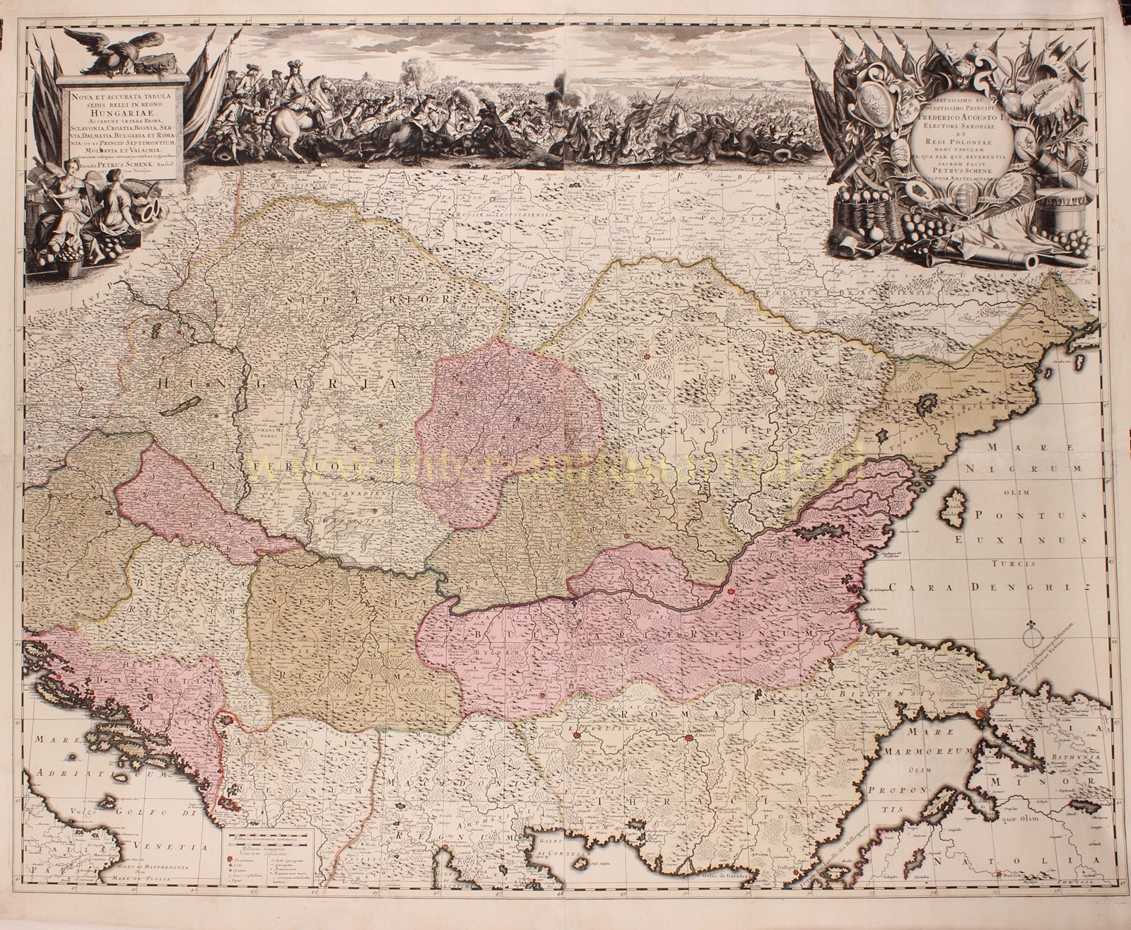
Koninklijk Hongarije – Pieter Schenk naar Luigi Marsigli, 1717
RARE WALL MAP OF THE THEATER OF WAR IN HUNGARY, DEDICATED TO AUGUSTUS II THE STRONG “Nova et accurata Tabula…
Lees verder€7.500
RARE WALL MAP OF THE THEATER OF WAR IN HUNGARY, DEDICATED TO AUGUSTUS II THE STRONG
“Nova et accurata Tabula sedis belli in Regno Hungariae. Accendunt cetera Regna Sclavonia, Croatia, Bosnia, Servia, Dalmatia, Bulgaria et Romania ut et Princip: Septimontium, Moldavia et Valachia, una cum reliquis circumjacentibus regionibus.” [New and accurate map of the theatre of war in the Kingdom of Hungary. Including the other kingdoms of Slavonia, Croatia, Bosnia, Serbia, Dalmatia, Bulgaria, and Romania as well as the principalities of Transylvania, Moldavia, and Wallachia, together with the surrounding regions.] Copper engraving after the work of Luigi Marsigli, published by Pieter Schenk in Amsterdam, 1717. Four joined sheets with original hand colouring, mounted on modern linen. Size: 91.5 x 111.8 cm.
This decorative wall map covers the area from the Adriatic to the Black Sea and from Poland to Macedonia, it focuses on the multiethnic, multilingual, and multinational Hungarian Empire. It includes the modern day nations of Hungary, Romania, Croatia, Bosnia and Herzegovina, Slovenia, Serbia, Moldova, Bulgaria, Kosovo, and parts of Montenegro, Macedonia, Ukraine, and Turkey. Hungary at this time stood divided between Austrian Habsburg influence from the west and Ottoman influence from the east.
The map commemorates the time of the Wars of the Holy League (also called the Great Turkish War), that was going on between the Ottoman Empire and the Holy League consisting of the Holy Roman Empire, Poland-Lithuania, Venice, Russia, and the Kingdom of Hungary.
The elaborate battle scene at the top of the map depicts the Battle of Vienna in 1683. The battle was fought by the Habsburg Monarchy, the Polish-Lithuanian Commonwealth and the Holy Roman Empire, under the command of King John III Sobieski against the invading Ottoman Empire and its vassal and tributary states, and took place at Kahlenberg Mountain near Vienna. The battle marked the first time Poland and the Holy Roman Empire had cooperated militarily against the Ottomans. The defeat of the Ottoman Empire is often seen as a turning point for its expansion into Europe, after which they would gain no further ground. In the ensuing war that lasted until 1699, the Ottomans would cede most of Ottoman Hungary to Leopold I, Holy Roman Emperor.
The Ottoman army numbered approximately 90,000 to 300,000 men and the battle is noted for including the largest known cavalry charge in history (18,000 Polish-Holy Roman Empire horsemen charging down the hills!)
The map was made after the design of count Luigi Marsigli (1658-1730), an Italian military engineer who surveyed Hungary and the Danube 1696-1699. The map is dedicated to Augustus II the Strong (1670-1733), then known as Frederick Augustus I. Augustus II was Elector of Saxony, Imperial Vicar, King of Poland (twice), and Grand Duke of Lithuania. He is perhaps best remembered as a patron of the arts and presumably supported publishing this map.
Price: Euro 7.500,-