

Indonesia, Sunda Strait, Sumatra and Java – Laurie and Whittle, 1794
€495
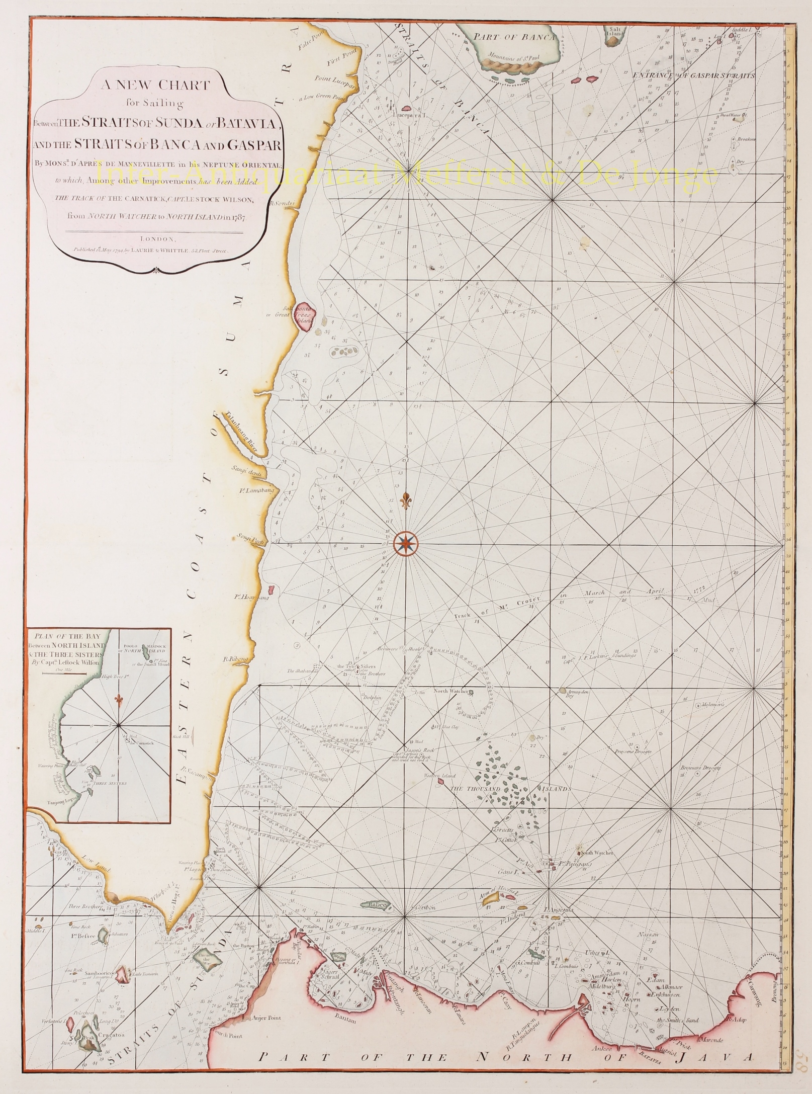
BRITISH SEA CHART OF THE SUNDA STRAIT, SUMATRA AND JAVA, SHOWING KRAKATOA AND BATAVIA, 1794
“A New Chart for Sailing between the Straits of Sunda or Batavia, and the Straits of Banca and Gaspar”, copper engraving published in London by Robert Laurie and James Whittle on 12 May 1794, and included in their nautical atlas The East-India Pilot, or Oriental Navigator. Coloured by a later hand. Size: 50.8 × 68.6 cm.
This detailed eighteenth-century antique sea chart of Java and Sumatra depicts the sailing route between the Sunda Strait, separating Java from Sumatra, and the Strait of Bangka and Gaspar Strait further north. The chart covers the southeastern coast of Sumatra, the northern coast of western Java, including Batavia (present-day Jakarta), and the southern approaches to the straits surrounding Bangka Island. Also depicted is the volcanic island group of Krakatoa, much of which was destroyed by a catastrophic eruption in 1883.
This region formed a vital link in the maritime trade routes between Europe and Asia. Ships entering the Sunda Strait from the Indian Ocean reached the Java Sea, from where they could continue northwards through the Strait of Bangka or Gaspar Strait towards the South China Sea. These passages thus provided access to the trading centres of Southeast Asia and China. Navigation, however, was hazardous: numerous reefs, shoals, small islands and treacherous currents made accurate nautical charts indispensable.
During the seventeenth and eighteenth centuries, the region was also the scene of intense commercial rivalry between the Dutch and English East India Companies. In 1602, the English established a trading post at Bantam in western Java, then an important port for the international pepper trade. The Dutch also established themselves in Bantam, but from 1619 onwards developed their own commercial and administrative centre further east, at Batavia. During a succession dispute in the Sultanate of Bantam, the Dutch East India Company (VOC) supported Sultan Haji, who granted the Dutch important trading privileges in return. In 1682, this brought an end to the position of the British East India Company in Bantam. The English subsequently turned their attention to other locations, including Bengkulu on the west coast of Sumatra, where they established a new trading post in 1685.
The chart dates from the final years of the Dutch East India Company (VOC). Batavia, shown along the southern edge of the chart, was still the VOC’s administrative and commercial headquarters in Asia. Just five years after this chart was published, the company was dissolved in 1799, and its remaining possessions and administrative responsibilities were transferred to the Dutch state.
The chart contains a wealth of practical navigational information. Along the coastlines and around the numerous islands are depth soundings, sandbanks, reefs and other navigational hazards. An extensive network of rhumb lines enabled mariners to plot their courses and assisted them in determining their positions. In addition to coastal settlements and landmarks, several sailing routes are marked, including that of the British ship Carnatick, commanded by Captain Le Stock Wilson, from North Watcher to North Island in 1787. At lower left is a separate inset chart of the bay between North Island and the Three Sisters, likewise based on Wilson’s surveys.
The original chart was compiled by the French hydrographer Jean-Baptiste d’Après de Mannevillette (1707–1780), who had published his influential nautical atlas Le Neptune Oriental in 1745. His chart of the sailing route between the Sunda Strait and the Strait of Bangka appeared in the substantially enlarged second edition of 1775. For their British edition of 1794, Laurie and Whittle used this chart as their starting point, incorporating additional hydrographic information, including the sailing route of the Carnatick.
The chart illustrates how French and British hydrographic knowledge was combined to produce increasingly accurate nautical charts of the busy but hazardous waters of the Indonesian archipelago. At the same time, it provides a fascinating historical record of international maritime trade routes and the European presence in Southeast Asia at the end of the eighteenth century.
Price: 495,-
