

Indonesia, West Coast of Sumatra – Laurie and Whittle, 1797
€495
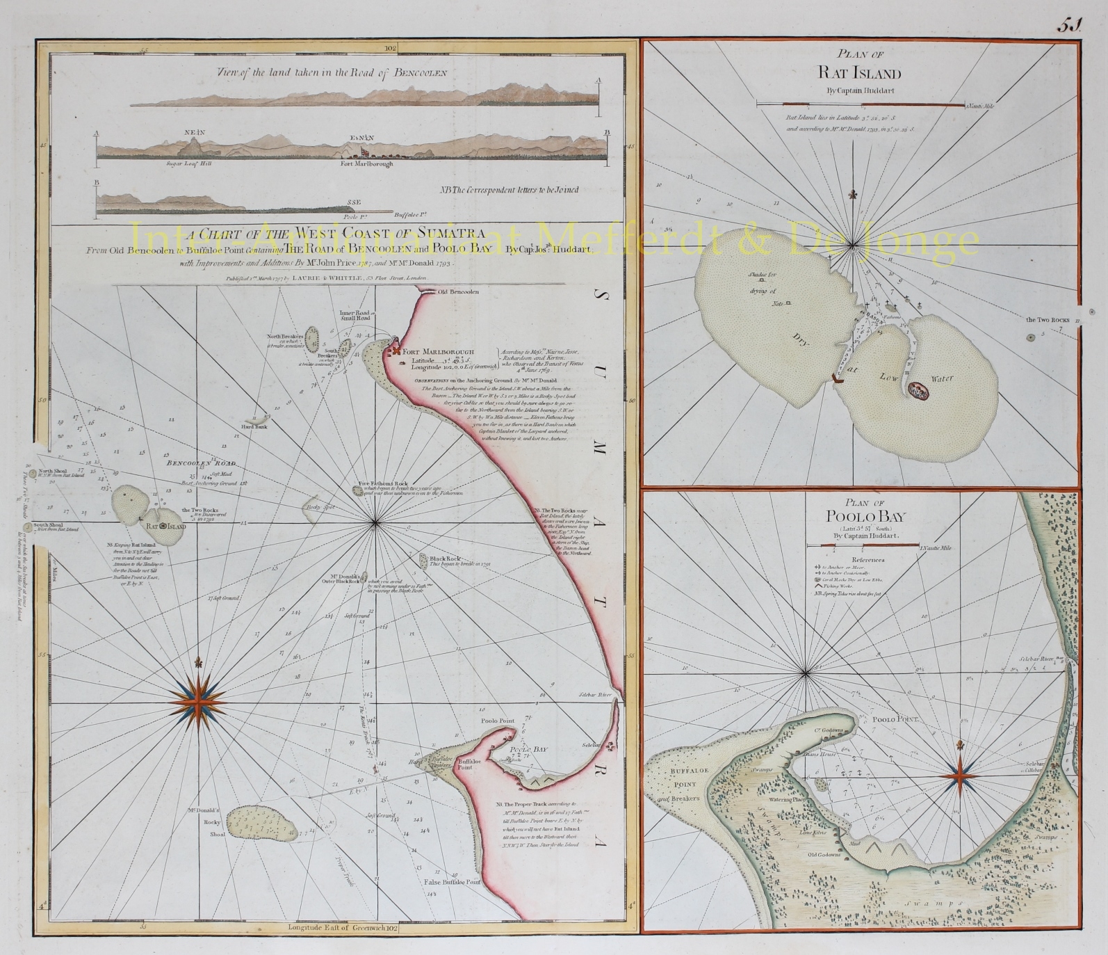
DETAILED BRITISH SEA CHART OF THE WEST COAST OF SUMATRA, SHOWING BENGKULU AND FORT MARLBOROUGH, 1797
“A Chart of the West Coast of Sumatra from Old Bencoolen to Buffaloe Point containing the Road of Bencoolen and Poolo Bay”, copper engraving based on surveys by Captain Joseph Huddart, supplemented with information provided by John Price in 1787 and McDonald in 1793. Published in London by Robert Laurie and James Whittle on 1 March 1797, and included in their sea atlas, The East-India Pilot, or Oriental Navigator. With two separate inset charts: “Plan of Rat Island” and “Plan of Poolo Bay”. Coloured by a later hand. Size: approx. 63.5 × 53.3 cm.
This detailed eighteenth-century sea chart depicts the west coast of Sumatra around Bengkulu, then known as Bencoolen, an important British trading centre for pepper. Besides accurately recording the coastline and approaches to the various anchorages, the chart provides extensive navigational information to help mariners safely negotiate this coast, with its numerous reefs and shoals.
The British East India Company established a trading settlement at Bengkulu in 1685, after largely losing its trading position at Bantam on Java to the Dutch East India Company (VOC). Sumatra offered the British a new opportunity to gain direct access to the lucrative pepper trade. In 1714, construction began on the imposing Fort Marlborough, which became the new centre of British commercial activities in the region. The original settlement subsequently became known as Old Bencoolen.
The large chart on the left covers the coastline from Old Bencoolen to Buffaloe Point, with Fort Marlborough serving as a principal landmark. The roadstead of Bencoolen is shown with numerous depth soundings, indications of sandbanks and rocks, information about the seabed, and directions for suitable anchorages. An extensive network of rhumb lines enabled navigators to plot their courses and approach the coast safely. Particularly noteworthy are the three coastal profiles across the top of the sheet. These illustrate the coastline, its hills and distinctive landmarks, including Fort Marlborough, as they would have appeared to sailors approaching from different positions at sea.
The upper right contains a separate plan of Rat Island (Pulau Tikus). This small island off the coast of Bengkulu was an important landmark for vessels approaching the roadstead. The plan shows the island, its surrounding reefs and the narrow passage leading to a sheltered anchorage. The accurate depiction of these hazardous shallows was essential for safe navigation.
The detailed chart at lower right depicts Poolo Bay (present-day Pulau Baai), a sheltered bay south of Fort Marlborough. Here, ships could anchor in relative safety to load and unload cargo. In addition to the coastline, water depths and anchorages, the chart identifies various facilities ashore, including warehouses (godowns), lime kilns for producing building materials, and places where ships could replenish their supplies of fresh water.
The chart was compiled from the hydrographic surveys of Captain Joseph Huddart, supplemented by observations made by John Price and McDonald. Laurie and Whittle published it as part of their extensive cartographic output for navigation in Asian waters. Their East-India Pilot drew, among other sources, on the work of the French hydrographer Jean-Baptiste d’Après de Mannevillette, whose Neptune Oriental was first published in 1745. This chart of Bengkulu and its surroundings represents a distinct British contribution to the hydrographic surveying and charting of the region.
Price: Euro 495,-
