

Land of Heusden – Bernard Jacob de Roij, 1754
€2.650
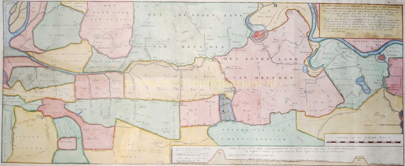
LARGE HYDRAULIC ENGINEERING MAP OF THE LAND OF HEUSDEN, 1754
“Kaart dienende tot het Project van den Heer M. van Barneveld […] wegens het maken van een Overlaat tusschen Baardwijk en Drunen, tot aflatinge van het overvloedig afkomende boven-Water, en voorkominge van Inundatien” [Map relating to the project of Mr M. van Barneveld […] for the construction of an overflow between Baardwijk and Drunen, for the discharge of excessive upstream water and the prevention of flooding], large copper engraving printed from three plates, based on the hydraulic engineering project of Martinus van Barnevelt (1691–1775), and worked out by Bernard Jacob de Roij (1716–1782), Pieter Adrianus Ketelaar and Gijsbert (Gerrit) Beket, 1754. Coloured by a later hand. Size: approx. 56 × 137 cm.
This impressive hydraulic engineering map shows the river landscape between the Biesbosch and Bergsche Veld in the west and ’s-Hertogenbosch and Fort Crèvecoeur in the east. At its centre are Heusden, the River Meuse and the polders of the historic Land of Heusden; to the south lie, among others, Vlijmen, Nieuwkuijk, Drunen, Baardwijk and Waalwijk. Dykes, sluices, waterways, roads, churches and windmills are shown in considerable detail. Along the lower edge is a profile of the Meer and Baardwijk dykes, at the point where the proposed overflow was to be constructed.
The project concerns what later became the Baardwijk Overflow. Its initiator was Martinus van Barnevelt, a former mayor of Gorinchem. Following the disastrous flood of 1741, he developed plans to improve the drainage of the Meuse, Waal and Merwede rivers.
High water regularly caused serious problems around ’s-Hertogenbosch. Water from several rivers and streams accumulated in the low-lying countryside and could only be discharged with difficulty. Van Barnevelt proposed a controlled outlet towards the west. At Baardwijk and Drunen, excess water was to pass through a broad opening in the dyke and then flow across the low-lying outer fields of the Langstraat and via the Oude Maasje towards the Bergsche Veld and Hollandsch Diep. In this way, pressure on both the area around ’s-Hertogenbosch and the Meuse could be reduced.
The map was made for the official assessment of Van Barnevelt’s project and accompanied a resolution of the States of Holland dated 20 November 1754. De Roij further developed the plan, while Ketelaar and Beket were involved as surveyors. Although the cartouche states that, owing to lack of time, only the principal hydraulic features could be included, the map provides an exceptionally detailed picture of the eighteenth-century Land of Heusden and its surroundings.
The plan was not implemented immediately. After further flooding it was reconsidered and eventually approved in modified form. By the end of 1766, the Baardwijk Overflow had been completed. With later alterations, it remained an important part of local water management until the early twentieth century.
Ultimately, a much more radical solution proved necessary. In 1883, it was decided to separate the Meuse permanently from the Waal. Between 1888 and 1904, the Bergsche Maas was dug for this purpose. The new river cut straight through the historic Land of Heusden and rendered the old overflow system largely obsolete.
The map is therefore an important document in Dutch hydraulic engineering history: a major eighteenth-century attempt to control the persistent flooding of the river district by means of controlled inundation.
Price: Euro 2.650,-
