

Groningen – Nicolaes Visscher + Petrus Schenk II, after 1719
€575
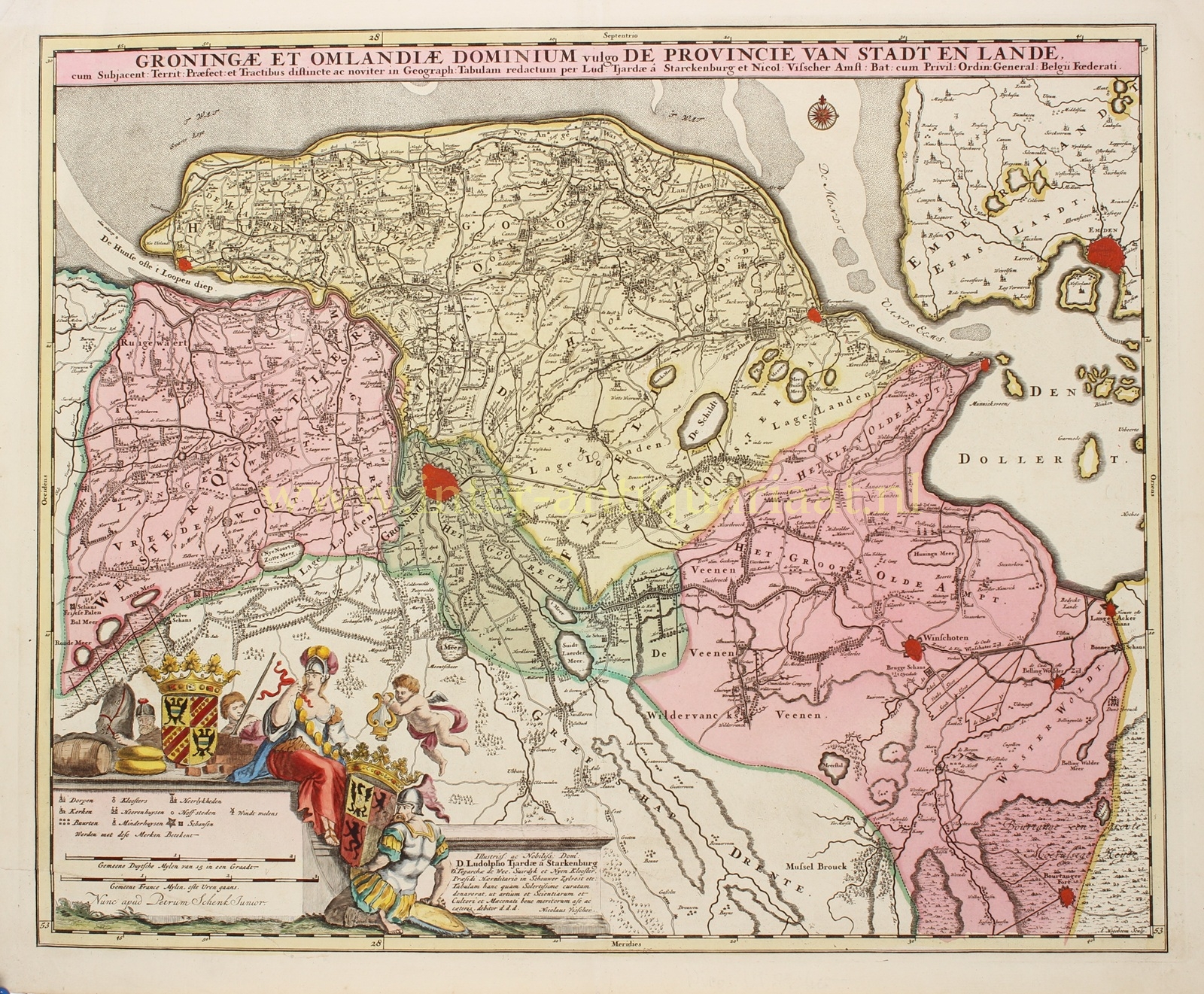


THE CITY AND LANDS OF GRONINGEN
“Groningae et Omlandiae Dominium vulgo de Provincie van Stadt en Lande“, copper engraving by A. Hogeboom, first published by Nicolaes Visscher in 1684, here in a reissue by Pieter Schenk the Younger after 1719. Original hand-colouring with later additions. Size: 46 × 56 cm.
Nicolaes Visscher II issued this map of the City and Lands of Groningen in collaboration with Ludolf Tjarda van Starkenborgh, a young nobleman from Wehe. Compared with earlier maps of the region, a number of small changes were introduced. For example, the settlements around Sappemeer are depicted in greater detail, and the city of Groningen itself is shown more elegantly and with improved topographical accuracy, surrounded by its seventeen bastions.
Sluices (“zijlen” and “verlaten” in Dutch) in the Old Provincial Dike are marked, as are several toll houses. A number of lakes that earlier mapmakers had left unnamed are here provided with names, such as the Lijskemeer north of Bourtange and the lakes near Opwierde and Meedhuizen. Some lakes have also been added, undoubtedly in connection with the progress of peat extraction. In southern Vredewold, Van Starkenborgh indicates three larger lakes, which in reality were much smaller and lay on a west–east line rather than southwest–northeast. Like the Hoetmansmeer near Wildervank shown here, they would eventually disappear through drainage. The nearby canals reflect the systematic peat-cutting along the Leekster Hoofddiep. The “Meer near De Punt” mentioned here for the first time is not the Paterswoldse Meer or the Friesche Veen. Those would only arise later in the Onland shown north of Paterswolde.
South of Woltersum, two circles mark the Wester- and Oostermeer. The long-vanished and now-forgotten Olderkerkerkmeer is also still indicated. Like many other lakes, it would in the 19th century be completely drained and disappear from the map.
Literature:
- Piet H. Wijk “Groninga dominium, Geschiedenis van de cartografie van de provincie Groningen en omliggende gebieden van 1545-1900” (2006), map no. 72.4
Price: Euro 575,-