

Amsterdam – Hendrik de Leth, 1734-36
€4.950
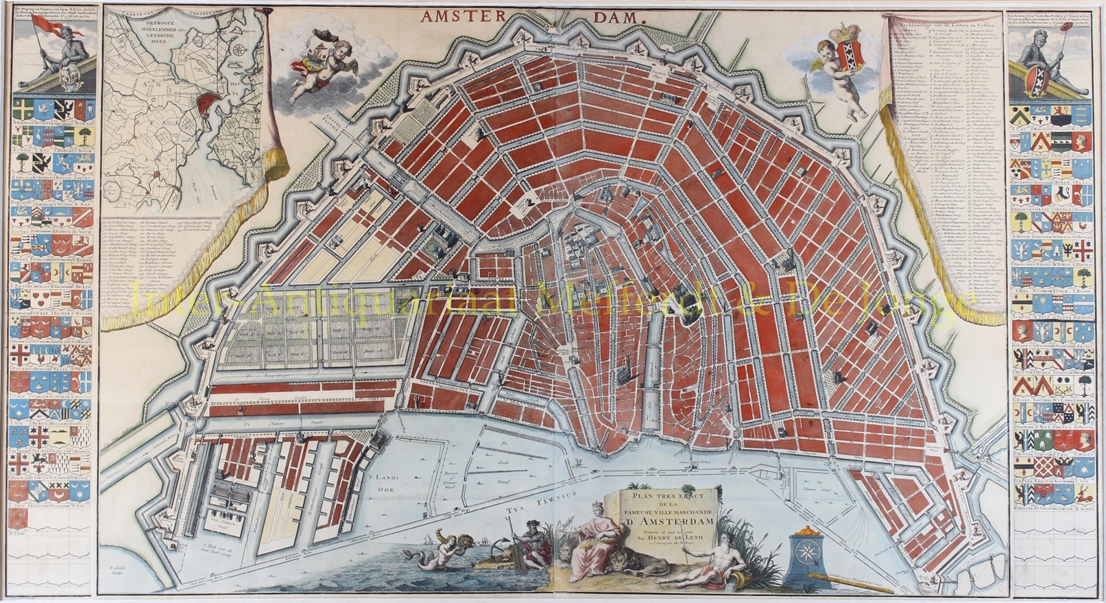
PLAN OF THE FAMOUS MERCANTILE CITY OF AMSTERDAM
“Plan tres exact de la fameuse ville marchande d’Amsterdam”. Copper engraving printed on four sheets, made by Hendrik de Leth and published between 1734 and 1736. With original hand-colouring. Size (plate mark): 57.5 × 105 cm.
On 24 and 27 April 1734, the following advertisement appeared in the Amsterdamsche Courant: “In Amsterdam, Hendrik de Leth at the Beurssluys is now publishing an entirely new and accurate plan of the city of Amsterdam, with many additions not found in any previous plans; embellished on either side with the Coats of Arms of the Honourable and Highly Esteemed Burgomasters of this city, from the Reformation to the present day, carefully revised by distinguished connoisseurs.” Buyers could choose between a richly decorated version with the family coats of arms of Amsterdam’s burgomasters on either side, and a plainer version without the armorial panels. Our example is the version with the coats of arms. [An example without the coats of arms can be found here in our collection.]
Hendrik de Leth, working amid numerous competitors such as Covens & Mortier, produced a reliable map that was well suited to use in the city’s administration. The distinguished French title seems intended to give the map a more prestigious character, but otherwise the print is entirely in Dutch, which was practical for craftsmen and administrative users.
Beneath the title we read: “Gravée et mis au jour Par Henry de Leth a l’enseigne du Pecheur”. [Engraved and published by Hendrik de Leth, at the sign of ‘De Visser‘.] The sign ‘De Visser‘ [The Fisherman] referred to the renowned map and print business of Nicolaes Visscher II. After his death in 1702, the business was continued by his widow Elisabeth Verseyl. Andries de Leth, who had worked as Visscher’s assistant, later took over the firm. Following his death in 1731, his son Hendrik de Leth continued the business and retained the familiar shop name ‘In den Visscher.’
The cartography of this plan is exceptionally clear and easy to read, with only the principal buildings shown in elevation. Hendrik de Leth based the map on an earlier plan but provided it with entirely new decoration. An attractive difference between De Leth’s map and earlier city plans is that he gave the buildings shown in elevation cast shadows. The light falls from the left, corresponding to the eastern morning sun.
To the left of the decorative, parted curtain is a “Caarte van Amstelland” [Map of Amstelland]. Remarkably, in the legend in the upper right-hand corner, nine of the buildings listed are followed by the letter “I”. The legend explains this with the words “NB Daar een I bystaat beteekent Jansenisten” [NB Where an I appears, it signifies Jansenists]. Jansenism, named after Cornelius Jansen (1585–1638), was a religious and political movement of the seventeenth and eighteenth centuries that developed particularly in France in response to certain developments within the Catholic Church and to the absolutism of contemporary rulers. Characteristic of the Jansenist way of life were ascetic rejection of worldly life and a pessimistic ethical outlook. Among other things, they also rejected papal infallibility. The fact that buildings associated with Jansenism are specifically marked on the map suggests that the engraver and publisher Hendrik de Leth sympathised with this political movement.
De Leth’s map has an armorial panel on either side. Together they provide an overview of the family coats of arms, names and years of appointment of Amsterdam’s burgomasters since the Alteratie of 1578. De Leth’s armorial panels served as the model for the closely resembling stained-glass windows in the Oude Kerk, although the windows in the church were supplemented with the burgomasters appointed up to and including 1753.
The central composition beneath the city plan is carefully and tastefully designed. The title cartouche is elegantly incorporated into a group of figures in which the personification of Amsterdam is flanked by the two lions from the city’s coat of arms and the river gods of the Amstel and IJ, while Fortuna rises from the sea. Like the title, the compass rose and scale bar have been given three-dimensional form as part of the composition. The city seal and coat of arms above the map are supported by two putti.
Literatur: Marc Hameleers (2003) “Amsterdamse Plattegronden 1866-2000”, map no. 114.
Price: Euro 4.950,- (incl. frame)
