

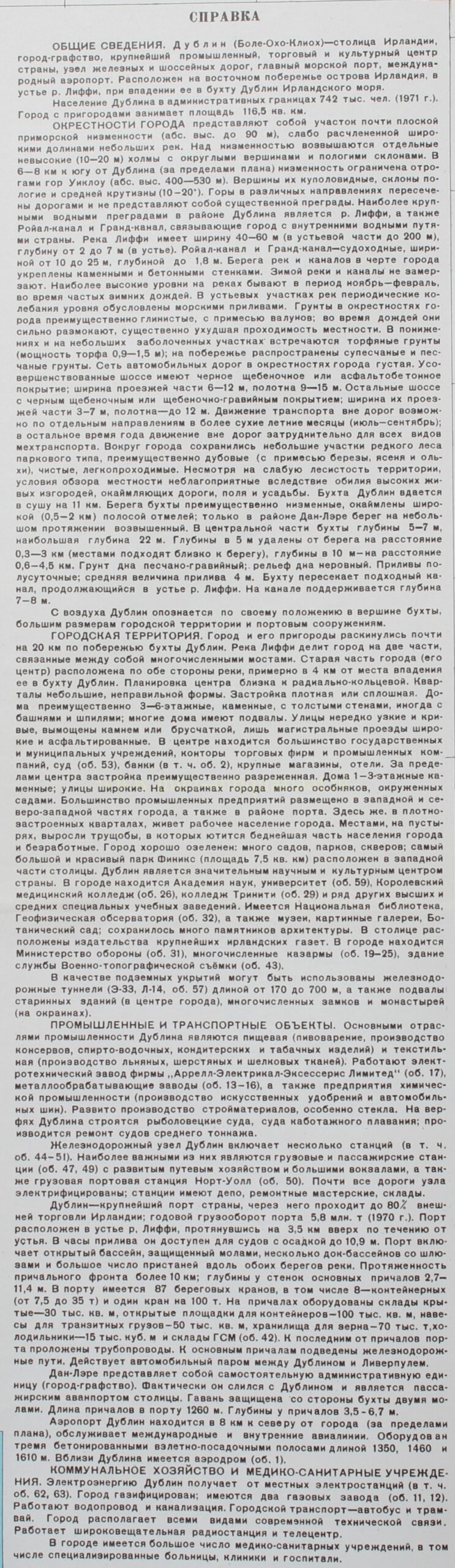
Dublin – Soviet map, 1980
€950


SECRET SOVIET MILITARY MAP OF DUBLIN, 1980
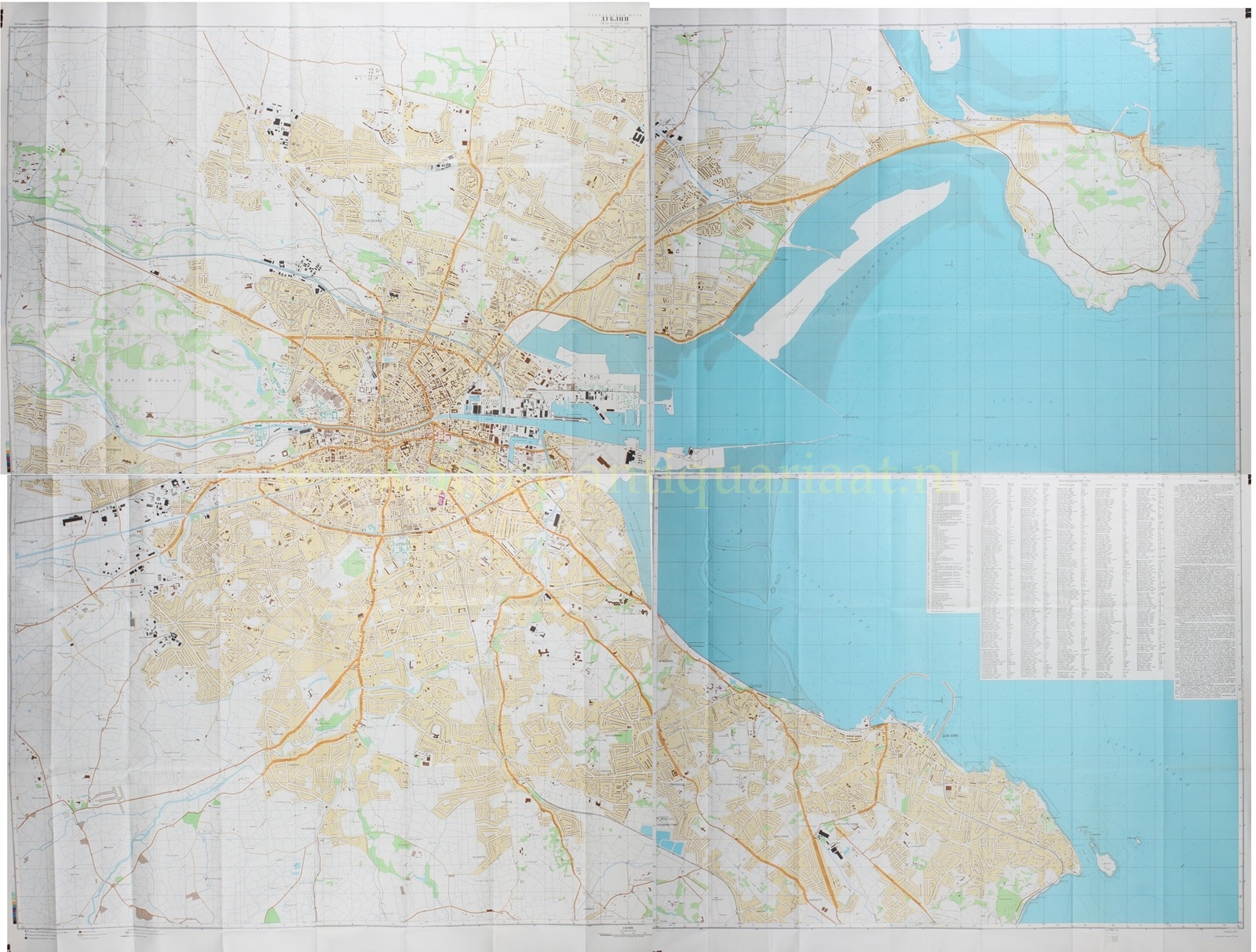
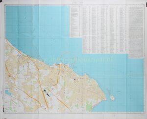
“ДУБЛИН” [Dublin], colour offset print on four sheets, published in 1980 by the Military Topographic Directorate of the General Staff of the Soviet Union. Size: two sheets 82.5 × 106.5 cm and two sheets 82.5 × 116.5 cm.
This rare four-sheet map of Dublin forms part of the secret cartographic production of the Soviet Union during the Cold War. From the 1940s onwards, the Military Topographic Directorate of the General Staff systematically compiled a global mapping corpus, in which Western European capitals, ports, and industrial centres were recorded with remarkable precision. These maps were intended for operational planning, logistical analysis, and strategic orientation, and are distinguished by their combination of topographical accuracy and a distinctly functional reading of city and landscape.
Together, the four sheets provide a detailed view of Dublin and its immediate surroundings: the urban area on both sides of the River Liffey, the coastline of Dublin Bay, the harbour, Dún Laoghaire, the northern and southern suburbs, connecting roads, railway lines, and the international airport.
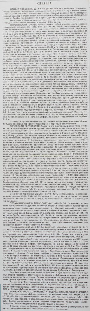
In the accompanying explanatory note [СПРАВКА, Spravka], Dublin is described as the capital of Ireland and as the country’s principal industrial, commercial, and cultural centre. The city is also characterised as an important railway and road junction, with a major seaport and an international airport.
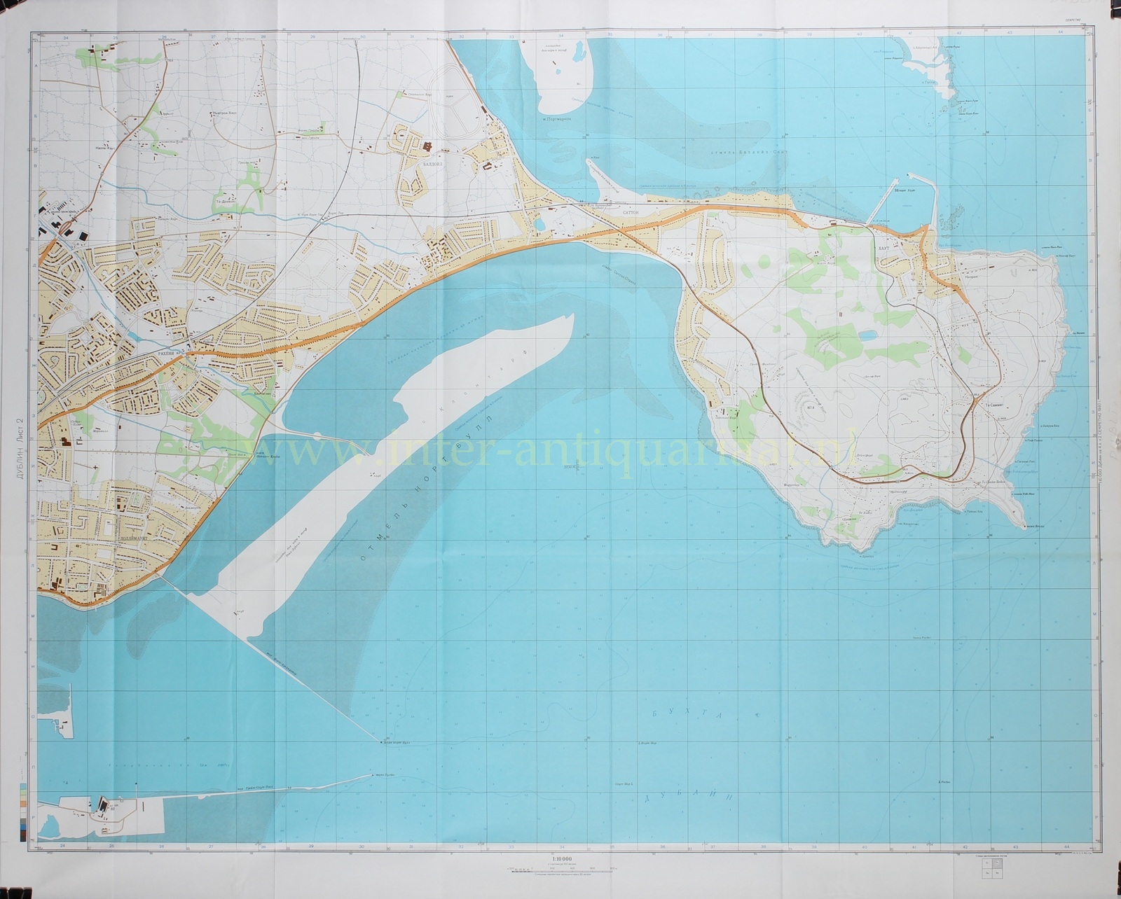
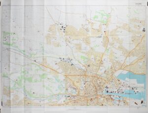
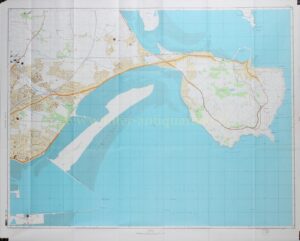
Dublin’s position at the mouth of the Liffey is of central importance in the Soviet analysis. The river divides the city into two parts and connects the urban centre directly with Dublin Bay. The Liffey, the Royal Canal, and the Grand Canal are shown not merely as topographical features, but as functional components of an urban and logistical system. Widths, depths, tidal conditions, quay walls, and navigability are all explicitly discussed in the explanatory text. Dublin Bay also receives particular attention: the bay, its shallows, harbour works, and artificially maintained navigation channel are treated both as elements of maritime accessibility and as potential constraints.
The harbour complex is one of the principal subjects of the map. In the Spravka, Dublin is described as Ireland’s largest port, responsible for a very substantial share of the country’s foreign trade. The port lies at the mouth of the Liffey and extends several kilometres inland. Quays, docks, locks, cranes, warehouses, cold stores, grain silos, pipelines, and railway connections are systematically recorded. Dún Laoghaire is mentioned separately as the capital’s passenger outport, virtually contiguous with Dublin and equipped with its own harbour installations.
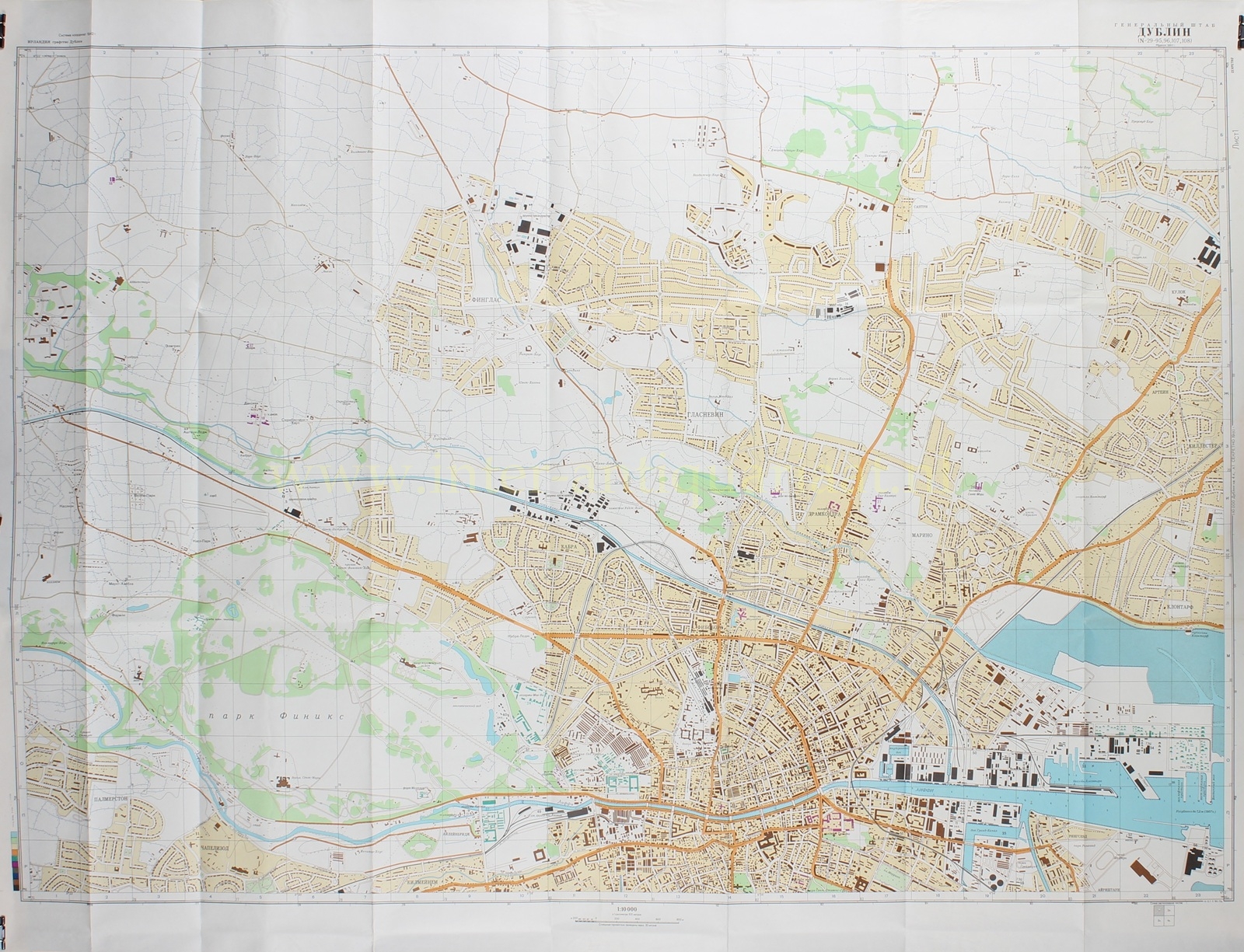
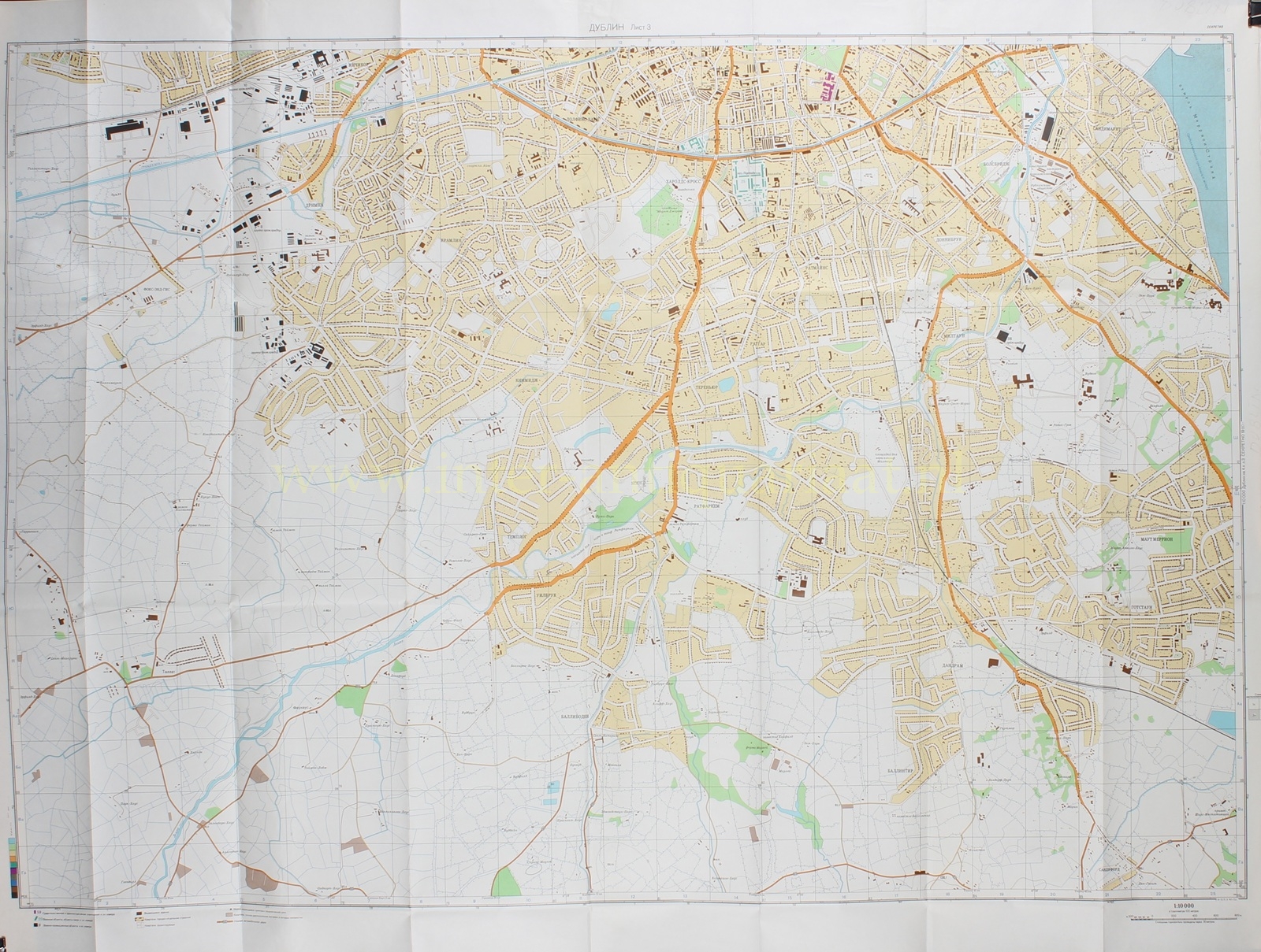
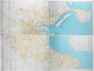
The urban area itself is also analysed from a strongly functional perspective. The old core lies on both sides of the Liffey, several kilometres before the river reaches Dublin Bay. Its plan is described as radial-ring in character, with irregular blocks. In the centre, the built fabric is dense and largely continuous, with stone buildings of three to six storeys, often with thick walls and cellars. Streets in the older districts are narrow and winding; main streets and newer traffic arteries are broader and better surfaced. The bridges across the Liffey naturally acquire significance within this system: they connect the two halves of the city and structure movement between the centre, harbour, and suburbs.
The Soviet map also devotes considerable attention to administrative, commercial, and cultural infrastructure. Government and municipal institutions, courts, banks, offices of commercial and industrial enterprises, major shops, and hotels are precisely located. Dublin is further described as an important scientific and cultural centre, with universities, Trinity College, libraries, museums, a botanical garden, an observatory, and numerous architectural monuments. Notably, military barracks, depots, and government services are also included in the inventory.
Dublin’s industrial structure is characterised in the explanatory note primarily by food processing and textile production. Breweries, canning, spirits, tobacco, ready-made clothing, and the production of linen, woollen, and silk fabrics are mentioned. In addition, the text records electrical engineering works, metalworking, chemical enterprises, building materials, and glass production. On the northern side of Dublin Bay, shipyards and facilities for the construction and repair of medium-sized vessels are described. The map thus records not only the visible city, but also its productive capacity, logistical functions, and potential strategic value.
As is characteristic of Soviet military mapping, the surrounding landscape is not treated as mere background. Soil conditions, vegetation, marshy areas, hedges, copses, coastal strips, and the passability of the terrain are explicitly discussed. The area around Dublin is described as a low coastal plain, locally cut by river valleys, with low hills to the south of the city. Roads are assessed in terms of their suitability for transport, while hedges and enclosures are noted as possible impediments to off-road movement. Even potential shelters—railway tunnels, cellars of older buildings, castles, and monastic complexes in the surrounding area—are included in the explanatory note.
Dublin Airport, north of the city, forms another important element of the map. It is described as the capital’s international airport, with concrete runways. Together with the harbour, railway lines, main roads, and canals, it forms part of the broader Soviet reading of Dublin as a node of transport, supply, and communication.
This map exemplifies the characteristic Soviet approach to cartography, in which a city is not merely depicted, but analysed as an integrated system of infrastructure, production, administration, and control. The combination of scale, detail, and analytical range makes it a remarkable document of military geography from the late Cold War.
Only after the dissolution of the Soviet Union in 1991 did the full scope and sophistication of this cartographic programme become apparent. Despite efforts to destroy the material, maps such as this reached the West. Today, they are valued as rare and compelling witnesses to a period in which urban space was analysed and recorded not only in civil, but also in strategic terms.
Price: Euro 950,-