

Leiden – Joan Blaeu, 1649
€2.150



LEIDEN AT THE HEIGHT OF ITS 17TH-CENTURY PROSPERITY, 1649
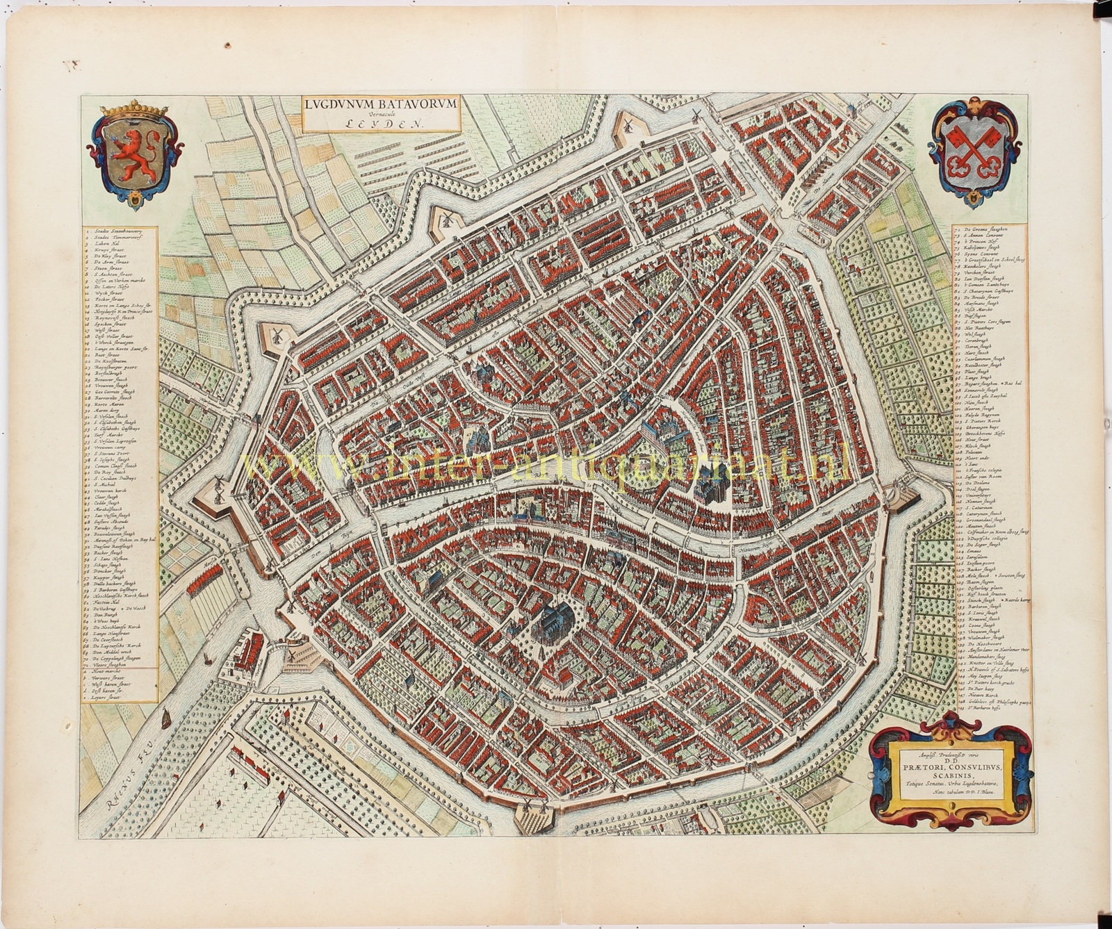
“LUGDUNUM BATAVORUM vernacule Leyden” [Lugdunum Batavorum, commonly called Leiden], copper engraving published in Amsterdam by Joan Blaeu in 1649, as part of his “Novum ac Magnum Theatrum Urbium Belgicae Liberae ac Foederatae“. With original hand colouring and heightened in gold and silver. Verso: Latin text on Leiden. Size: 42 × 53.7 cm.
This richly executed city plan of Leiden shows the city shortly after its fifth expansion of 1644, at a time when Leiden was experiencing extraordinary economic and demographic growth. Blaeu depicts the densely built-up city in bird’s-eye view, surrounded by ramparts, bastions, city gates and the broad encircling canal. The map thus provides a remarkably detailed picture of Leiden just five years after the expansion of 1644 and ten years before the next major enlargement of 1659.
Although Leiden ranked administratively as the fourth city in the States of Holland, after Dordrecht, Haarlem and Delft, by the middle of the seventeenth century it was, in terms of population, the largest city in Holland after Amsterdam. This spectacular growth was primarily due to the textile industry. The arrival of large numbers of skilled workers and entrepreneurs from the Southern Netherlands had greatly stimulated Leiden’s woollen-cloth and other textile industries. By around 1640, at least half of the city’s population was involved in textile production. The Laecken-Halle, opened in 1640 as the centre for the inspection and trade of Leiden cloth, is prominently listed in the legend of Blaeu’s map.
The university, founded in 1575, had meanwhile transformed Leiden into an international centre of scholarship, printing and publishing. According to tradition, William of Orange granted the city its university as a reward for its steadfast resistance during the Spanish siege of 1574. Its foundation also served a practical purpose: the young Dutch Republic urgently needed its own lawyers, physicians and Protestant theologians.
The oldest part of Leiden developed around the Burcht, clearly visible near the centre of the map. On this artificial mound, strategically situated at the confluence of the Old and New Rhine, originally stood a wooden fortification. In the twelfth century this was replaced by a circular stone wall. From this area the settlement expanded, among other directions, along the southern Rhine dyke, now the Breestraat.
A striking feature of Leiden’s urban layout is the absence of a single large central market square. Instead, commerce was concentrated along the branches of the Rhine, on quays, bridges and widened streets. Blaeu depicts this intricate network of canals, streets and alleys in great detail. Extensive legends on either side of the map identify a total of 149 numbered streets, buildings and other locations. The arms of Holland appear at upper left, while the coat of arms of Leiden is shown at upper right.
The Latin title “Lugdunum Batavorum” reflects the belief, widespread during the sixteenth and seventeenth centuries, that Leiden occupied the site of the Roman Lugdunum mentioned by classical authors. This identification is no longer accepted: Roman Lugdunum is now generally sought in the vicinity of Katwijk.
At lower right, Blaeu dedicates the map to the city government: “PRAETORI, CONSULIBUS, SCABINIS, Totique Senatui, Urbis Lugdunobatavae.”
That is, to the bailiff, burgomasters, aldermen and the entire council of Leiden. The map was therefore not merely an accurate city plan, but also a splendid representation of Leiden’s power, prosperity and civic pride.
Price: Euro 2.150,-
