

Breda – Joan Blaeu, 1649
€1.350


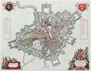

Breda, copper engraving published in Amsterdam in 1649 by Joan Blaeu, as part of his town book “Toneel der Steden van de Vereenighde Nederlanden.” Coloured by a later hand. Size: 41 × 54 cm.
This is the best-known plan of Breda, showing the street pattern with buildings depicted in elevation. Although the map was only published in 1649, the situation represented dates to around 1622, incorporating the fortification extensions carried out under Prince Maurice but without the crownworks, a configuration that remained essentially unchanged until 1682.
The map is based on surveys carried out by Balthasar Florisz. van Berckenrode for his siege map of 1637. The privilege protecting that map expired in 1643, after which it could be freely reproduced.
On the verso, Joan Blaeu provides a Latin description of the city:
Breda, not a large city, has a circuit of walls measuring scarcely four thousand paces, so that it can be walked around in about an hour. Its jurisdiction, however, extends much further and encompasses numerous villages. Originally belonging to the dukes of Brabant, the city was alienated in 1350 by Duke John III and sold to Jan II of Polanen. Through his heiress Johanna, Breda passed in 1404, as part of her dowry, into the possession of the House of Nassau. In the sixteenth and seventeenth centuries the city played an important role in the conflict between Spain and the Dutch Republic: it was taken in 1567 by the Duke of Alva, recovered in 1577 by the Nassaus, occupied again by the Spanish in 1581, and in 1590 retaken by Prince Maurice through the stratagem of the peat barge. After a prolonged siege, the city fell in 1625 to Spinola, before being definitively recaptured in 1637 by Frederick Henry, Prince of Orange (to whom the map is dedicated).
The city is traversed by the river Aa, which divides within the moats and then flows onward toward the waters of Holland. Through a system of sluices, the water level can be regulated and, when required, directed into the surrounding fields. The name Breda is sometimes derived from the word “broad,” referring to the river spreading out widely at this location.
The ground plan of the city is triangular, with the castle projecting into the fortifications on one side. Within the city rises a tall tower commanding extensive views over the surrounding region. Breda comprises approximately twelve hundred houses and combines strong defensive qualities with an element of urban refinement, expressed in its avenues, walks, and gardens.
The fortifications are particularly strong and modern in design. The city is enclosed by walls, ramparts, and double moats, reinforced with bastions, bridges, and an arsenal. The enceinte is pierced by three gates, while the castle forms a separate point of access. The moats vary in width and contain numerous earthen outworks, some connected to the city, others designed to regulate the flow of water. Along the outer edge runs a breastwork and a thorn hedge intended to hinder attack.
Beyond the main moat lie advanced works, including demi-lunes and hornworks, accessible by bridges and providing additional protection. Behind these extends a sloping glacis that encloses the entire defensive system. All elements of this fortification belt are so arranged that they mutually support one another, both in elevation and in range, allowing defenders to move between lines and provide overlapping fields of fire.
The surrounding landscape is likewise integrated into the system of defence. Through a carefully controlled network of waterways, sluices, and inundations, the terrain around the city could be flooded, rendering it difficult for enemy forces to approach. Even the suburb and an island opposite the castle, used for turning vessels, were incorporated into this defensive structure and protected by separate works.
Price: Euro 1.350,-