

Tilburg – Soviet map, 1978
€950


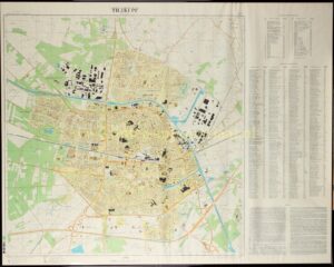


SECRET SOVIET MAP OF TILBURG
“ТИЛБУРГ”, colour offset print made in 1978 under the supervision of Colonel V.T. Viktorov. Size: 90 × 113 cm.
With the fall of the Soviet Union in 1991, the Cold War came to an end. A period of ideological confrontation and constant threat of war was over. In hindsight, it appears that the Soviet Union possessed better maps of the Netherlands (and many other Western countries) than the Dutch did themselves. These Russian maps from the late 1970s reveal an unsettling level of detail.
From the 1940s onward, the Soviet Union began systematically mapping the world. They produced city maps with unprecedented precision, showing features such as bus stops and government buildings. Several dozen such maps were made of the Netherlands.
Maps like this one of Tilburg were intended for operational planning. Government institutions, post offices, factories, barracks, and airfields are all carefully indicated in Cyrillic script. For many bridges, their size and load-bearing capacity are recorded, along with information on the navigability and width of associated rivers and canals. The height of dams and dikes, types of crops, and road surfaces are also documented. The map is marked “секретно” [secret].
In addition to the fact that many Western countries made topographic maps freely available—something that communist spies undoubtedly exploited—the Soviet Union had access to satellite information from the 1960s onward. Further data was obtained through extensive espionage activities. It is highly likely that Soviet spies operated via the embassy in the Netherlands. But not only that. In the 1950s, all truck drivers from Eastern Europe were screened by the Dutch intelligence services. This policy was later relaxed, but in the 1980s renewed warnings were issued about Ukrainian truck drivers lingering near military sites. Soviet passenger aircraft also occasionally disappeared from Dutch radar; it later emerged that these aircraft had descended to take photographs of locations of interest.
However, these maps were probably not created solely for wartime use. Detailed information was also recorded about crops, roadside vegetation, and the location of facilities such as post offices—seemingly irrelevant data if one were planning only a military offensive or even a devastating nuclear strike. This likely reflects the belief within the communist leadership in Moscow, up until the end of the Cold War, that the West would eventually fall to communism.
These maps allowed them to better understand the world beyond their borders in advance. It was assumed to be only a matter of time before the Soviet Union would also exert control there. When that moment arrived, these maps would prove highly useful.
The full extent to which the Soviet Union mapped the world only became clear after the collapse of the communist superpower in 1991. Despite orders from Moscow to destroy the maps, many found their way to the West. Through Russian officers, they came into the possession of universities, collectors, companies, and even military organizations.
If one reads the СПРАВКА [Spravka, explanatory note] at the bottom, it is quite sobering:
Tilburg is described as an important industrial centre and transport hub in the south of the Netherlands, strategically located near the Belgian border and connected by railways, highways, and the Wilhelmina Canal. The city has approximately 150,000 inhabitants (over 200,000 including suburbs) and a relatively compact area.
The surrounding landscape is flat, with sandy soils, a high groundwater level, and a dense network of canals and drainage ditches, making off-road movement difficult. Infrastructure is well developed: roads, bridges, and waterways are described in detail, including load capacity, width, and navigability—clearly reflecting a military perspective focused on logistics and mobility.
The city itself has a predominantly radial-ring layout with densely built-up districts and a historic centre south of the railway station. Industry is mainly located along the Wilhelmina Canal and on the outskirts. Tilburg is characterised as a diverse industrial centre, with emphasis on mechanical engineering, radio electronics, chemical production, and especially textiles (notably wool). There are also food-processing industries, building materials production, and light industry.
The main industrial sector is mechanical engineering, particularly radio electronics. Three radio-electronics plants (nos. 8, 9, 10) produce equipment such as radios, cathode-ray tubes, mercury switches, and control and distribution panels. Other factories (including nos. 7, 13) manufacture excavators, road construction machinery, transport and electrical equipment, gears, gearboxes, steam boilers, reservoirs, ventilation and moulding installations, refrigeration units, and machinery for the metalworking and textile industries. The chemical industry is also developed; chemical plants (including nos. 11, 12) produce industrial chemicals, dyes, pharmaceuticals, rubber, and plastics. The city also hosts enterprises producing construction materials, leather goods, footwear, and clothing. The most important military-industrial facility is a radio-electronics plant (no. 10). Tilburg is a major centre of the textile industry, especially wool. Numerous factories are present: spinning mills (nos. 13, 53–56), textile factories (nos. 57–61), and a weaving mill (no. 62). The food industry is also developed, with dairy plants, a brewery (no. 16), and a slaughterhouse (H-13). Large food storage facilities (no. 40) are located on the western edge of the city.
Double-track electrified railway lines connect Tilburg to ’s-Hertogenbosch, Boxtel, and Breda, while a single-track non-electrified line leads to Turnhout. The Tilburg railway junction includes a passenger station (no. 43) and a marshalling yard (no. 44), with extensive rail facilities, large railway workshops (no. 21), covered storage areas, and a station building.
The port of Tilburg is located on the Wilhelmina Canal and comprises two harbours: an industrial harbour (H, E-13) and Piushaven (M-11, 12). The quays of Piushaven are 900 metres long.
Tilburg receives electricity from a local thermal power plant (no. 6), connected to the national grid. The city is supplied with gas via a pipeline (diameter approx. 300 mm) from the Ruhr area (FRG); in addition, there is a local gas plant (no. 6). Tilburg has a water supply system, with groundwater as the main source; water is distributed via water towers (no. 61). There is a sewer system and water treatment facilities (nos. 41, 42). The principal means of urban transport is the bus, with 15 routes connecting the centre to the outskirts and surrounding towns. Tilburg is equipped with all forms of modern communication; both local and long-distance telephone systems are automated. Telephone and telegraph communications operate via underground cables and radio-relay lines. Near the city is an underground communications centre of the Dutch Ministry of Defence, as well as a regional communications hub. The city has a well-developed network of medical facilities, the largest being the municipal hospital (L-12).
Price: Euro 950,- (incl. frame)