

Amsterdam, harbour expansion plan – after Adriaan Huet, c. 1874
€575
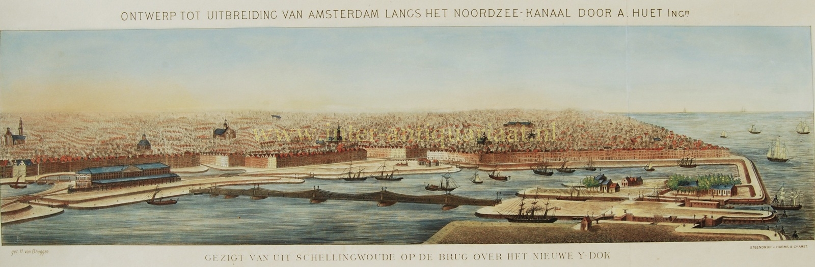
AMSTERDAM: A NEVER-REALIZED PLAN FOR A NEW HARBOUR, C. 1874
“Ontwerp tot uitbreiding van Amsterdam langs het Noordzee-Kanaal. Gezigt van uit Schellingwoude op de brug over het nieuwe Y-dok” [Plan for the Expansion of Amsterdam along the North Sea Canal. View from Schellingwoude towards the Bridge over the New IJ Dock], lithograph after a drawing by H. van Bruggen, printed in Amsterdam by V. Harms & Co., based on the expansion plan devised by engineer Adriaan Huet, c. 1874. Coloured by a later hand. Size: 14.7 × 55.5 cm.
During the nineteenth century, Amsterdam was in danger of losing its position as an international trading centre and major port. Its traditional maritime access from the North Sea, via the Zuiderzee and the IJ, had become increasingly difficult for large seagoing vessels due to silting. To improve access to the city, the North Holland Canal was constructed between 1819 and 1824, connecting Amsterdam with Den Helder via Alkmaar. However, with its numerous bends, bridges and locks, this lengthy detour soon proved inadequate for the ever-increasing size of seagoing vessels.
The solution was to establish a direct connection to the North Sea by cutting through the dunes near Velsen, where North Holland was at its narrowest. Construction of the North Sea Canal began in 1865, and the canal was officially opened by King William III on 1 November 1876.
The construction of the canal also offered an opportunity to modernize Amsterdam’s harbour on an unprecedented scale. Engineer Adriaan Huet (1836–1899) devised an ambitious expansion plan involving the reclamation of a substantial part of the IJ. New buildings and port facilities would extend along a broad new waterway. In 1874, Huet published a detailed account of his proposed scheme.
This panoramic print illustrates Huet’s vision of Amsterdam’s future waterfront. The view is taken from the northern shore near Schellingwoude, looking towards the city. Amsterdam’s skyline stretches across almost the entire composition, with its church towers, domes and countless red-tiled rooftops. In front of the city lies the proposed new harbour, with extensive quays, landing stages, docks and a long bridge spanning the planned IJ Dock.
To the left, a monumental new railway station dominates the foreground, with an extensive covered platform hall. Situated immediately alongside the new harbour, the station was a key element in Huet’s ambitious scheme to establish closer connections between maritime transport and the railway network.
Under the proposed scheme, a substantial part of the existing IJ would be reclaimed to create new port facilities. A long stretch of reclaimed land, protected by a new embankment, was intended to form the future southern bank of the North Sea Canal. Between this new shoreline and the existing city, an extensive sheltered harbour basin would be created: the new IJ Dock.
The proposal also included an additional complex of locks on the River Amstel, near the Berebijt, and a new railway connection between Sloterdijk and the Amstel. The embankment between the Stadsrietlanden and Schellingwoude, incorporating the Oranjesluizen (Orange Locks), likewise formed part of the extensive reconfiguration of the IJ associated with the construction of the North Sea Canal.
Huet’s expansion plan was never carried out in its proposed form. Instead, Amsterdam’s harbour developed along different lines, including the construction of the Eastern Trade Quay (Oostelijke Handelskade) and Amsterdam Central Station on artificial islands in the IJ. Completed in 1889, the station permanently transformed the city’s historic waterfront.
This remarkable panoramic print therefore depicts an Amsterdam that never existed: an ambitious vision of the future from a period when the city was investing in major infrastructure projects in an effort to regain its position as an international centre of commerce.
Price 575,-
