

Nuremberg – Georg Christoph Eimmart + Jacob Sandrart, 1667
€4.500


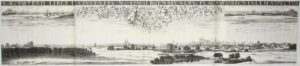


THE FREE IMPERIAL CITY OF NUREMBERG AFTER THE THIRTY YEARS’ WAR
“S[acri] R[omani] Imperii Liberae Civitatis Norimbergensis Vers[us] Plagam Orientale Aspectus.“ [View of the Free City of Nuremberg of the Holy Roman Empire, looking towards the East.] Copper engraving on 4 mounted sheets, made by Georg Christoph Eimmart and published in 1667 by Jacob von Sandrart. Size: 28.5 × 135 cm.
Monumental panorama of Nuremberg, seen from the east. The city extends across the full width of the print in a long, low horizon. To the right of centre the castle rises above the city, and along the skyline stand numerous gates, monasteries, towers, churches and important buildings.
The city proper is shown behind a broad foreground of fields, meadows, orchards, watercourses and country lanes. In the foreground travellers, peasants and herdsmen go about their business; carts, walkers and small groups of figures enliven the landscape. This makes the print more than a profile of walls and towers: Eimmart presents Nuremberg as an urban centre within an economic and agrarian hinterland. The city is enclosed by its gates and walls, yet at the same time connected to the suburbs, roads, waterworks and country estates that made its daily functioning possible.
In the late Middle Ages and the early 16th century, Nuremberg was one of the most powerful free imperial cities of the Holy Roman Empire. The city was renowned for its trade and high-quality craftsmanship: printers, engravers, goldsmiths, bronze-casters, armourers and instrument-makers worked there for a market that reached far beyond Franconia. In the 15th and 16th centuries it enjoyed an exceptional period of flourishing as a centre of the German Renaissance, associated with names such as Albrecht Dürer, Veit Stoss, Adam Kraft, Peter Vischer the Elder and Hans Sachs.
By around 1667, however, that great Renaissance flowering already lay behind the city. The Thirty Years’ War had hit Nuremberg hard. During the conflict the city attempted to preserve its neutrality, but was confronted with the billeting of troops, war levies, economic disruption and military pressure. In 1632 Nuremberg was occupied by the army of the Swedish king Gustavus Adolphus and subsequently besieged by the imperial commander Wallenstein. The population fell from more than 45,000 inhabitants before the war to around 25,000 afterwards.
It is precisely against this background that the panorama acquires additional meaning. It shows not a ruined or impoverished city, but an orderly, proud and recognisable Reichsstadt. The inscription above the city’s coat of arms — “Civitas Imperialis Noremberga. Pacis Amabilis Virore Germinet” [May the imperial city of Nuremberg flourish in the lovely freshness of peace] — is telling in this respect. The print celebrates Nuremberg as a city that, despite economic decline and political tension, continued to assert its identity as a free imperial city, a Protestant urban centre and the heir to a great cultural past. (And this at a time when Nuremberg struggled greatly in the 17th century to recover from the damage of the Thirty Years’ War, as its municipal debts mounted.)
Georg Christoph Eimmart (1638–1705), descended from a Nuremberg family of artists and scholars, was eminently suited to such a commission. He was not only a draughtsman and engraver, but also an astronomer. Jacob von Sandrart (1630–1708), a scion of the well-known Sandrart family of artists and publishers, was one of the most productive copper engravers in Nuremberg in the second half of the 17th century. He was the most expensive engraver in the city.
The result of this collaboration: “Außer Zweifel ist dies die schönste und richtigste Abbildung von der Stadt” [Without doubt this is the finest and most accurate depiction of the city].
Below the image, forty numbered locations allow the print to be read topographically from left to right:
1 Peterskirche – Church in the south-eastern suburb (near the present-day St. Peter district).
2 Glockenhof – At the time a suburb; today a district to the south/south-east of the old inner city.
3 Gostenhof and St. Rochuskapelle – At the time a western suburb with the cemetery and chapel of St. Rochus.
4 Einfluß des Fischbachs und darauf gebaute Wasserkunst – The point where a stream reached the city and where a waterwork stood.
5 Spittlertor – City gate on the south-western side of the city wall.
6 Kartäuserkloster – Carthusian monastery (remains of the monastic buildings have formed part of the Germanisches Nationalmuseum since 1857).
7 Frauentor – City gate on the southern side of the city (near the present-day Hauptbahnhof area).
8 St. Klara– Protestant church (in today’s Lorenzer Altstadt).
9 St. Martha – Medieval church near Königstraße (today the Evangelical Reformed Church of St. Martha).
10 St. Jakob – Church of the Teutonic Order (still an important church in the south-western Altstadt).
11 Zeughaus – The municipal arsenal; storehouse for weapons and military matériel.
12 Obere Waage – City weigh house, where goods were officially weighed; important for trade and taxation.
13 Weißer Turm – Gate tower of the older city wall (still one of the recognisable towers in the inner city today).
14 Die Peunt – Nuremberg’s municipal building and works yard (in today’s Lorenzer Altstadt).
15 Lorenzkirche – One of the principal churches of Nuremberg (St. Lorenz).
16 apelle am Roßmarck St. Salvator – Carmelite church, later known as the Salvatorkirche (demolished in 1817).
17 Barfüßerkloster – Former Franciscan monastery; “Barfüßer” (barefoot) refers to the unshod, sandal-wearing mendicant order.
18 St. Katharina – Former Dominican convent.
19 Wasserturm– Defensive and water tower on the Pegnitz; part of the city’s water and defence system.
20 Die Zwei Schuldtürme – The two “debtors’ towers” served as a prison, among others for debtors.
21 Heilig-Geist-Spital – Situated on the Pegnitz, then the largest hospital in Nuremberg.
22 Augustinerkloster – Former monastery of the Augustinian Hermits.
23 Frauenkirche – Church of Our Lady on the Hauptmarkt, known for the “Männleinlaufen” (mechanical clock) on the west façade.
24 Johanniskirche – Church and cemetery in the western suburb of St. Johannis.
25 Neutor – Gate on the north-western side of the city, by the route towards St. Johannis.
26 Gleißhammer – A hamlet to the east of the city (today a district).
27Sebalduskirche– The oldest large parish church in Nuremberg, dedicated to the city’s patron saint Sebaldus.
28 Town hall.
29 The point where the river Pegnitz enters the city.
31 Tiergärtnertor – City gate by the castle.
32 Nürnberger Burg – Residence of the Emperor (Nuremberg Castle).
33 St. Egidienkirche – Church beside the Benedictine Schottenkloster (Scots’ monastery) of St. Egidien.
34 Laufer Schlagturm – Tower of the inner Laufer Tor in the city wall.
35 Fünfeckturm – Pentagonal tower of the castle.
36 Kornhaus – Grain storehouse (from the 19th century the “Mauthalle“).
37 Luginsland– High watchtower by the castle, intended to look out far across the surrounding countryside.
38 Fröschturm – City-wall tower in the north-eastern part of the city, also a prison.
39 St. Bartholomäus – Parish church of the eastern suburb of Wöhrd. (Wöhrd is today a district directly to the east of the Altstadt.)
40 Laufer Tor – Eastern city gate towards Lauf an der Pegnitz.
Price: Euro 4.500,-
