

Gelderland – Covens & Mortier, 1721-1737
€2.450


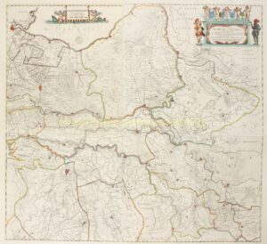


18TH-CENTURY WALL MAP OF THE DUCHY OF GUELDERS, COUNTY OF ZUTPHEN AND DUCHY OF CLEVES
“Nouvelle Description du Duché de Gueldres Comprennant aussi le Comté de Zutphen avecq le Duché de Cleves, la Mayerie de Bois-le-Duc etc. | Nieuwe Beschrijvinge van het Hertogdom van Gelre begrijpende mede het Graefschap Zutphen met het Hertogdom van Cleef en andere bijgelegen Landen.” Copper engraving printed on four joined sheets. First published by Cornelis Danckerts before 1656, here in the sixth edition, published by Covens & Mortier between 1721 and 1737. Coloured by a later hand. Size (plate mark): 81.7 × 89 cm.
The Duchy of Guelders and the County of Zutphen had been closely connected since the Middle Ages. During the Eighty Years’ War, most of Guelders came under the control of the Dutch rebels and subsequently formed one of the seven provinces of the Dutch Republic. The County of Zutphen constituted one of its three administrative quarters, alongside Nijmegen and the Veluwe. The southern part of the former duchy, known as Upper Guelders, remained largely under Spanish rule. Following the War of the Spanish Succession, this territory was divided between several powers, with the Dutch Republic acquiring the area known as Staats-Opper-Gelre, which was administered directly by the States General.
Guelders and Zutphen occupied a strategically important position along the Rhine, Waal and IJssel rivers. Cities such as Nijmegen, Arnhem and Zutphen served as regional centres of trade and government. The region benefited from its river trade but was also repeatedly affected by military conflicts, particularly during the Franco-Dutch War (1672–1678) and the War of the Spanish Succession (1701–1714), when hostile armies crossed and occupied parts of the region.
To the east lay the Duchy of Cleves. Following the succession crisis of 1609, Cleves came under the control of Brandenburg through the Treaty of Xanten in 1614. This arrangement was formally confirmed in 1666. Although Cleves remained part of the Holy Roman Empire, it was governed by Brandenburg-Prussia and, from 1701, formed part of the Kingdom of Prussia.
Cleves and Guelders shared a long border, together with numerous cultural, religious and economic ties. The frontier region was characterised by considerable religious diversity, with Reformed, Lutheran and Roman Catholic communities living on both sides of the border. The boundary was also relatively permeable, with people regularly crossing it for employment, trade and religious reasons.
Almost eighty years separate the first edition of this map from the present sixth edition. During that period, several alterations were made to the copper plates. These include the expanded fortifications around Nijmegen, constructed under the direction of Menno van Coehoorn in 1702.
Another significant addition appears on the lower right-hand sheet, where an inscription reads: “Routes of Wegen der France met haar leger Plaatse” (Routes or Roads of the French, with the Positions of their Army). During the War of the Spanish Succession, French forces advanced through the region towards Nijmegen in 1702. The map records their route from Venlo towards Nijmegen, indicating military encampments at Venlo, Geldern, Sonsbeck, Xanten, Kalkar, Goch and Kranenburg. At Kranenburg, the route divides, with one branch leading towards Nijmegen and the other passing through Klarenbeek, the site of a former castle near Nütterden, towards Cleves.
Further alterations include the enlarged fortifications of Wesel. Southeast of Goch, the small village marked “Wees” (Weeze) in the earlier edition is now depicted as a substantial fortified settlement.
The upper right-hand sheet also incorporates the projected Pannerdensch Canal. Completed in 1707, this artificial waterway connected the Upper Rhine to the Lower Rhine and established a new bifurcation of the Rhine, directing water into the Waal and the Pannerdensch Canal.
The elaborate title cartouche in the upper right-hand corner is flanked by two allegorical figures in armour, probably representing Mars and Bellona, the Roman god and goddess of war. Bellona holds an inverted torch, traditionally associated with death. She is shown standing over an infant, apparently piercing its body with the point of her sword. Above the cartouche are the coats of arms of Guelders-Jülich and the County of Zutphen, flanked by those of Cleves and ’s-Hertogenbosch.
Literature: Reinier Blonk and Peter van der Krogt, Geldria Ducatus: Geschiedenis en Cartobibliografie van het Hertogdom Gelderland (2021), map 44.6, pp. 300–304.
Price: Euro 2.450,-
